


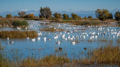
Fairfax County utilized GeoAI and ArcGIS technology to efficiently map and protect its hemlock trees from the invasive woolly adelgid, ensuring targeted pest management and preservation of its evergreen canopy.

Fairfax County, Virginia, faced a significant challenge with the hemlock woolly adelgid, a pest threatening its hemlock trees and evergreen canopy. The county’s Urban Forest Management Division (UFMD), tasked with preserving the urban forest, recognized that mapping hemlocks was critical to combat infestations. Collaborating with the GIS Division, they leveraged geospatial artificial intelligence (GeoAI) using ArcGIS technology to analyze aerial photography. By employing a deep learning model and additional filtering techniques—like analyzing greenness, infrared data, and lidar intensity—UFMD pinpointed evergreen trees requiring treatment, significantly narrowing the target area from 116,521 to 33,110 trees.
The GIS Division’s analysis enabled the Forest Pest Branch to efficiently develop a treatment plan and allocate resources. Utilizing ArcGIS Field Maps, the mobile team located and treated infested trees. This streamlined approach, integrating GIS tools with ground efforts, ensured precise targeting and resource optimization. The collaboration highlighted the effectiveness of automating tree detection, laying the groundwork for future projects aimed at preserving Fairfax County’s tree canopy.
Building on this success, Fairfax County used the evergreen data from the hemlock project to train a new deep learning model to map evergreens across the Mason Neck peninsula. This project covered nearly 9,000 acres and identified over 36,000 evergreen trees. The automated process enabled more efficient planning and monitoring, particularly in areas with dense tree clusters. Fairfax County’s innovative use of GeoAI for forest management demonstrates the transformative potential of technology in addressing environmental challenges.
FULL STORY: GeoAI Helps Stave Off Pest Infestation of Hemlock Trees


BLM To Rescind Public Lands Rule
The change will downgrade conservation, once again putting federal land at risk for mining and other extractive uses.
California Lawmakers Move to Protect Waterways
Anticipating that the Trump EPA will reinstate a 2017 policy that excluded seasonal wetlands and waterways from environmental protections.

City Nature Challenge: Explore, Document, and Protect Urban Biodiversity
The City Nature Challenge is a global community science event where participants use the iNaturalist app to document urban biodiversity, contributing valuable data to support conservation and scientific research.

Alabama: Trump Terminates Settlements for Black Communities Harmed By Raw Sewage
Trump deemed the landmark civil rights agreement “illegal DEI and environmental justice policy.”

Planetizen Federal Action Tracker
A weekly monitor of how Trump’s orders and actions are impacting planners and planning in America.

The 120 Year Old Tiny Home Villages That Sheltered San Francisco’s Earthquake Refugees
More than a century ago, San Francisco mobilized to house thousands of residents displaced by the 1906 earthquake. Could their strategy offer a model for the present?

Ken Jennings Launches Transit Web Series
The Jeopardy champ wants you to ride public transit.

BLM To Rescind Public Lands Rule
The change will downgrade conservation, once again putting federal land at risk for mining and other extractive uses.

Indy Neighborhood Group Builds Temporary Multi-Use Path
Community members, aided in part by funding from the city, repurposed a vehicle lane to create a protected bike and pedestrian path for the summer season.
Urban Design for Planners 1: Software Tools
This six-course series explores essential urban design concepts using open source software and equips planners with the tools they need to participate fully in the urban design process.
Planning for Universal Design
Learn the tools for implementing Universal Design in planning regulations.
Clanton & Associates, Inc.
Jessamine County Fiscal Court
Institute for Housing and Urban Development Studies (IHS)
City of Grandview
Harvard GSD Executive Education
Toledo-Lucas County Plan Commissions
Salt Lake City
NYU Wagner Graduate School of Public Service