


City Profiles
Explore cities through an urban planning lens.
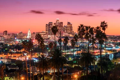
Los Angeles: An Urban Planner's Guide to the City
A diverse global city, Los Angeles is characterized by unique neighborhood nodes and is a center of global trade and entertainment.
Basics
- State: California
- Incorporation date: April 4, 1850
- Area: 501.55 sq mi
- Statehood: September 9, 1850
- Population*: 3,898,747
- Type of government: Strong mayor–council
- Planning department website: Los Angeles Department of City Planning
- Comprehensive plan: General Plan Overview
*Current as of 2020 Census.
Los Angeles's indigenous history
The area now known as Los Angeles was home to the Tongva, later known as the Gabrielino, people, whose name roughly translates as “people of the earth.” There are 31 known sites believed to have been Tongva villages with as many as 500 households each in the Los Angeles region. One of the most well-documented, Kuruvungna village, was located near a spring from the Santa Monica Mountains that is now part of a historic site on the campus of University High School in Santa Monica. The Tataviam and Chumash people lived to the north and on the Channel Islands.
Colonization, Spanish missions, and the Mexican-American War
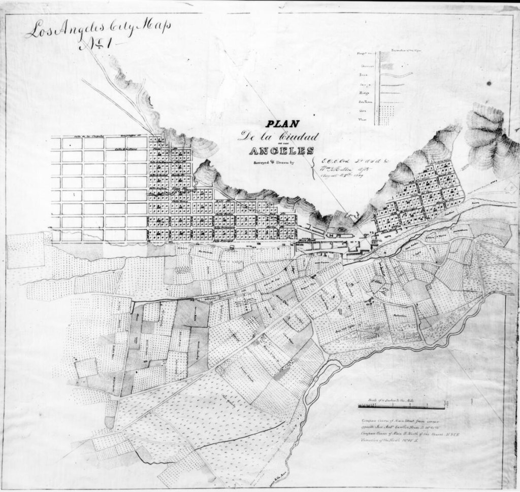
Spanish explorer Juan Rodriquez Cabrillo arrived in 1542, meeting Gabrieleno/Tongva people off the shores of Santa Catalina and San Pedro islands. The Spanish Mission Period begins with Mission San Diego, founded by Junipero Serra in 1769. Serra launched the construction of a network of Spanish missions up and down the California coast. The Spanish occupation of Los Angeles gained steam with the founding of Mission San Gabriel, east of today’s downtown Los Angeles, in 1771. In 1781, El Pueblo de Nuestra Señora la Reina de los Ángeles was established by a group of 44 settlers known as the Pobladores, migrants sent from Mexico to found the new town.
After the independence of the Mexican Republic in 1821, Los Angeles served as regional capital of Alta California. Over 25 days in 1846, part of Northern California briefly existed its own breakaway republic, also known as the Bear Flag Republic, after a group of American settlers declared the new nation in the area north of San Francisco. The Bear Flag Rebellion foreshadowed the imminent Mexican-American War, which culminated in the ceding of Alta California to the United States in 1848.
20th century growth: Rail, Hollywood, and immigration
Unlike its Gold Rush neighbors to the north, Los Angeles remained a relatively small settlement until the late 19th and early 20th century, when the discovery of oil and the completion of transnational railroads contributed to the more rapid growth of the city. Population growth highlighted the need for a bigger, more sustainable water supply than the local area could provide. In 1913, the Los Angeles Water Project became one of the largest and most infamous infrastructure projects in the nation, bringing water from the Owens River to Southern California via a series of aqueducts. The project has sustained the region but caused severe water shortages and associated problems in the Owens Valley.
The economy diversified with the growth of the aerospace industry, the film industry in Hollywood, and the ports of Los Angeles and Long Beach, which together make up one of the largest port complexes in the country. During World War II, the L.A. area produced large numbers of warships and airplanes. Like other California cities, Los Angeles is required to create and update a General Plan, which includes 35 Community Plans.
The city, which is home to immigrant communities from over 140 countries, has also been marked by racial tensions. These flared most disastrously during the Watts Uprising in 1965 and the 1992 Los Angeles uprising following the Rodney King verdict. Since the 1990s, many of the city’s historically underserved neighborhoods are experiencing various levels of gentrification, with mixed results for residents.
21st century concerns: Homelessness, climate, and car dependency
Los Angeles has a notoriously high rate of homelessness, a crisis that city leaders have struggled to address effectively and humanely. In 2023, an estimated 46,260 people were unhoused in Los Angeles on any given night, a growth of 9 percent since the prior year.
L.A.’s location on the Pacific Coast makes it vulnerable to sea level rise, coastal erosion, and flooding. Meanwhile, the dry Los Angeles foothills and mountain communities face increasing wildfire risk. As climate disasters become more common, the city and county must contend with how to manage infrastructure and protect residents.
Once home to an extensive network of streetcars—whose demise is fictionalized in Who Framed Roger Rabbit?—Los Angeles quickly became dominated by cars and freeways during the mid-20th century, when the interstate highway system crisscrossed the city with overpasses. Though known for sprawl, Los Angeles is also home to some of the densest neighborhoods in the country, and recent investment into the region’s public transit system—boosted in part by its successful bid to host its third Olympic Games in 2028—is creating a more comprehensive and reliable transit network. After decades of advocacy, the city is undergoing a mobility revolution as residents demand more transit options and projects years in the making are finally improving transportation across the region. In 2023, the opening of the Regional Connector marked a major improvement in the county’s rail system and was hailed by advocates as a transformative project that could help reduce the region’s auto dependency.
Key planning milestones in Los Angeles
- 1908: Los Angeles created the first municipal zoning ordinance in the country, using zoning regulations to separate uses and ensure industrial uses were not mixed into residential areas.
- 1970: The federal Clean Air Act is passed, ushering in a new era for Los Angeles air quality. By the 1970s, Los Angeles faced the worst smog problem in the nation, with air pollution reaching unhealthy levels more than 200 days per year. The Clean Air Act led to the creation of the California Air Resources Board and a slew of new regulations targeting pollution in the transportation and industrial sectors.
- 1973: The city’s first dedicated busway opens along Interstate 10, later leading to the creation of the L.A. rail and subway system.
- 1990: The Blue Line opens as the city’s first light rail line, connecting downtown Los Angeles to Long Beach.
- 1999: The Adaptive Reuse Ordinance passes, marking a major step forward for downtown Los Angeles. Once known as a post-industrial neighborhood in decline, downtown and the adjacent ‘Arts District’ became popular residential and commercial areas thanks to the conversion of hundreds of former factories and warehouses into housing, art studios, restaurants, and shops.
- 2008: Los Angeles County voters pass Measure R, a half-cent sales tax to fund transportation and public transit projects. In 2016, voters approved Measure M, an expansion of the tax with no sunset date that added new transit projects.
- 2016: The city launched Re:code LA, an effort to reassess and reform the zoning code, which saw its last comprehensive update in 1946. Re:code LA shifts the code away from purely Euclidean zoning to a hybrid form of zoning regulations that also includes form-based codes.

Preserving Houston’s ‘Naturally Occurring Affordable Housing’
Unsubsidized, low-cost rental housing is a significant source of affordable housing for Houston households, but the supply is declining as units fall into disrepair or are redeveloped into more expensive units.
Houston Metro Plan Centers Safety, Accessibility
A new plan from the city’s transit agency focuses on improving the rider experience and boosting safety, but remains uncommitted to previous plans to build new BRT lines.

Retro-silient?: America’s First “Eco-burb,” The Woodlands Turns 50
A master-planned community north of Houston offers lessons on green infrastructure and resilient design, but falls short of its founder’s lofty affordability and walkability goals.

Urban Design for Planners 1: Software Tools
This six-course series explores essential urban design concepts using open source software and equips planners with the tools they need to participate fully in the urban design process.
Planning for Universal Design
Learn the tools for implementing Universal Design in planning regulations.
Heyer Gruel & Associates PA
City of Moreno Valley

Institute for Housing and Urban Development Studies (IHS)
City of Grandview
Harvard GSD Executive Education
NYU Wagner Graduate School of Public Service
City of Cambridge, Maryland
Newport County Development Council: Connect Greater Newport