


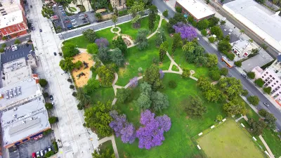
A new University of Toronto study analyzes anonymous GPS data from smartphones to track how people use and interact with green spaces.

Park planning has become increasingly data-driven. The use of location data from mobile devices is one of the latest trends in data-driven park planning, as previously reported in this article. Specifically, the use of such data for studies on park visitors can be more affordable and accurate than conducting in-person counts and/or surveys at parks.
In this article by Alexa Battler, researchers at the University of Toronto explain how anonymous cellphone data can help park planners to strike a better balance between the needs of people and wildlife. Their study, published in the journal PLOS Computational Biology, is among the first to use anonymous GPS data from smartphones to track how people interact with green spaces, potentially impacting biodiversity.
GPS data has been used to gauge people’s activities in green spaces before, but most of the studies have relied on volunteers signing up to have their information used, painting a limited or partial picture. For this study, researchers relied on data from Mapbox, a company that creates custom maps for major apps including Facebook, Snapchat and Uber. Users’ identities are kept anonymous while their locations are gathered every two hours. The information is typically used for marketing and business purposes, such as selecting the busiest hubs to place a new franchise.
The Mapbox data allowed researchers to track which qualities of parks attracted the most people, including recreation amenities such as picnic benches and trails, and types of land coverage such as forests and swamps. For more information, please read the source article.
FULL STORY: How do people use public parks? Researchers study cellphone data to understand green space use

Los Angeles County Invests in Wildfire Recovery for Parks, Trails, and Open Space
The $4.25 million RESTORE Program supports the recovery of parks, trails, and open spaces damaged by the January 2025 wildfires through targeted grants that promote community healing, wildfire resilience, and equitable access to nature.

Healing Through Parks: Altadena’s Path to Recovery After the Eaton Fire
In the wake of the Eaton Fire, Altadena is uniting to restore Loma Alta Park, creating a renewed space for recreation, community gathering, and resilience.

Parks for All: LA Looks to Residents to Help Shape Park Equity and Access
Los Angeles is launching a citywide park needs assessment to gather resident input on improving its park system, addressing inequities in access, and making the case for increased funding and long-term investments.

Alabama: Trump Terminates Settlements for Black Communities Harmed By Raw Sewage
Trump deemed the landmark civil rights agreement “illegal DEI and environmental justice policy.”

Planetizen Federal Action Tracker
A weekly monitor of how Trump’s orders and actions are impacting planners and planning in America.

The 120 Year Old Tiny Home Villages That Sheltered San Francisco’s Earthquake Refugees
More than a century ago, San Francisco mobilized to house thousands of residents displaced by the 1906 earthquake. Could their strategy offer a model for the present?

Ken Jennings Launches Transit Web Series
The Jeopardy champ wants you to ride public transit.

BLM To Rescind Public Lands Rule
The change will downgrade conservation, once again putting federal land at risk for mining and other extractive uses.

Indy Neighborhood Group Builds Temporary Multi-Use Path
Community members, aided in part by funding from the city, repurposed a vehicle lane to create a protected bike and pedestrian path for the summer season.
Urban Design for Planners 1: Software Tools
This six-course series explores essential urban design concepts using open source software and equips planners with the tools they need to participate fully in the urban design process.
Planning for Universal Design
Learn the tools for implementing Universal Design in planning regulations.
Clanton & Associates, Inc.
Jessamine County Fiscal Court
Institute for Housing and Urban Development Studies (IHS)
City of Grandview
Harvard GSD Executive Education
Toledo-Lucas County Plan Commissions
Salt Lake City
NYU Wagner Graduate School of Public Service