


The L.A. County Board of Supervisors just approved the Parks Needs Assessment Plus (PNA+), which highlights the need for transforming degraded lands such as landfills and oil fields into parks and open spaces, particularly in underserved communities.

What is the percentage of land area in Los Angeles County dedicated to regional recreation and conservation? Which areas of L.A. county should be prioritized for environmental conservation and restoration? What is the acreage of parkland in the rural portions of the county? How many miles of regional trails are there and where are they located?
The Los Angeles County Board of Supervisors just approved a study that answers these questions and more. Called the 2022 Parks Needs Assessment Plus (PNA+), this report complements and offers information not previously included in the 2016 Los Angeles Countywide Parks and Recreation Needs Assessment (PNA). Specifically, PNA+ contains data and analyses in support of expanding land conservation and restoration, transit to parks, and other strategies to meet regional and rural recreation needs, especially in the most vulnerable communities.
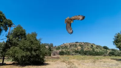
The PNA+ is L.A. County's 30x30 strategy which aligns with state and federal goals to conserve 30 percent of lands and coastal waters by the year 2030 to fight climate change and advance biodiversity and conservation. PNA+ addresses both environmental conservation and restoration. It identifies priority areas for environmental conservation which are areas that offer the most environmental benefits as measured by species diversity, significant habitat, habitat connectivity, proximity to a waterbody, and habitat type. Examples of these areas include portions of the Antelope Valley, Puente-Chino Hills Wildlife Corridor, San Gabriel Mountains, Santa Monica Mountains, and Santa Clarita Valley which are not currently owned and managed by public agencies and conservancies.
The study also calls out priority areas for environmental restoration. These are areas that have the most environmental burdens with respect to groundwater threat, hazardous waste, poor air and water quality, and pollution burden. Examples include oil fields (such as the Inglewood Oil Field in Baldwin Hills), brownfields, landfills (such as the Puente Hills Landfill), and other degraded lands which may be converted to parks and open space in the future. The restoration of degraded lands is of great importance and a matter of environmental justice in Los Angeles County where numerous underserved communities are plagued with environmental burdens.
Based on its key findings, PNA+ offers various recommendations and next steps which are explained in detail in the report and organized by the following categories: funding priorities; park, trail, and open space provision; collaboration and coordination; access and information; community engagement; and capacity building.
FULL STORY: LA County board adopts updated park needs assessment

A Greener LA County: 623 Acres of New Parkland for Communities
Los Angeles County is investing $17 million to create 623 acres of new parks and open spaces, expanding access to nature, advancing equity, and enhancing community health and well-being.

Bringing Communities Together: Lunar New Year Festivities Across LA County
To celebrate the Lunar New Year, LA County Parks is hosting free community festivals at 61 parks, featuring cultural performances, food tastings, crafts, and interactive activities that honor the Year of the Snake and promote unity and tradition.
How LA County Parks are Fostering Equity
Los Angeles County's Department of Parks and Recreation actively engages the public through diverse methods to ensure parks and recreation programming align with community needs and priorities.

Alabama: Trump Terminates Settlements for Black Communities Harmed By Raw Sewage
Trump deemed the landmark civil rights agreement “illegal DEI and environmental justice policy.”

Planetizen Federal Action Tracker
A weekly monitor of how Trump’s orders and actions are impacting planners and planning in America.

The 120 Year Old Tiny Home Villages That Sheltered San Francisco’s Earthquake Refugees
More than a century ago, San Francisco mobilized to house thousands of residents displaced by the 1906 earthquake. Could their strategy offer a model for the present?

BLM To Rescind Public Lands Rule
The change will downgrade conservation, once again putting federal land at risk for mining and other extractive uses.

Indy Neighborhood Group Builds Temporary Multi-Use Path
Community members, aided in part by funding from the city, repurposed a vehicle lane to create a protected bike and pedestrian path for the summer season.

Congestion Pricing Drops Holland Tunnel Delays by 65 Percent
New York City’s contentious tolling program has yielded improved traffic and roughly $100 million in revenue for the MTA.
Urban Design for Planners 1: Software Tools
This six-course series explores essential urban design concepts using open source software and equips planners with the tools they need to participate fully in the urban design process.
Planning for Universal Design
Learn the tools for implementing Universal Design in planning regulations.
Clanton & Associates, Inc.
Jessamine County Fiscal Court
Institute for Housing and Urban Development Studies (IHS)
City of Grandview
Harvard GSD Executive Education
Toledo-Lucas County Plan Commissions
Salt Lake City
NYU Wagner Graduate School of Public Service