


The National Recreation and Park Association has created a new virtual library offering a collection of publicly available databases and visualizations for park and recreation professionals and advocates.

Park and recreation agencies need data to help tell their stories, answer key questions, and inform decision-making. Fortunately, the National Recreation and Park Association (NRPA) recently created a new Data and Mapping Resource Library that offers a collection of relevant, publicly available databases and visualizations curated for park and recreation professionals and advocates. These public resources serve as a starting point for exploring data on a variety of topics.
As NRPA's Austin Barrett explain in this post, the library is organized by “Categories” and “Topics.” The four categories included are: 1) Social and Demographic Factors, 2) Health and Wellness, 3) Environmental Resiliency and 4) Park Access and Information. Topics are more specific and cover a range of different subject areas ranging from: “Age and Gender” to “Environmental Quality” to “Social and Economic Equity.” Users may further narrow resources by using the “Filter by” functionality on the right-hand side of the library.
A four-minute training video is also provided below that demonstrates how to access, filter and use the data resources in the library.
FULL STORY: Data: The Next Frontier

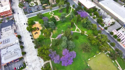
Los Angeles County Invests in Wildfire Recovery for Parks, Trails, and Open Space
The $4.25 million RESTORE Program supports the recovery of parks, trails, and open spaces damaged by the January 2025 wildfires through targeted grants that promote community healing, wildfire resilience, and equitable access to nature.

Healing Through Parks: Altadena’s Path to Recovery After the Eaton Fire
In the wake of the Eaton Fire, Altadena is uniting to restore Loma Alta Park, creating a renewed space for recreation, community gathering, and resilience.

Parks for All: LA Looks to Residents to Help Shape Park Equity and Access
Los Angeles is launching a citywide park needs assessment to gather resident input on improving its park system, addressing inequities in access, and making the case for increased funding and long-term investments.

Alabama: Trump Terminates Settlements for Black Communities Harmed By Raw Sewage
Trump deemed the landmark civil rights agreement “illegal DEI and environmental justice policy.”

Planetizen Federal Action Tracker
A weekly monitor of how Trump’s orders and actions are impacting planners and planning in America.

The 120 Year Old Tiny Home Villages That Sheltered San Francisco’s Earthquake Refugees
More than a century ago, San Francisco mobilized to house thousands of residents displaced by the 1906 earthquake. Could their strategy offer a model for the present?

BLM To Rescind Public Lands Rule
The change will downgrade conservation, once again putting federal land at risk for mining and other extractive uses.

Indy Neighborhood Group Builds Temporary Multi-Use Path
Community members, aided in part by funding from the city, repurposed a vehicle lane to create a protected bike and pedestrian path for the summer season.

Congestion Pricing Drops Holland Tunnel Delays by 65 Percent
New York City’s contentious tolling program has yielded improved traffic and roughly $100 million in revenue for the MTA.
Urban Design for Planners 1: Software Tools
This six-course series explores essential urban design concepts using open source software and equips planners with the tools they need to participate fully in the urban design process.
Planning for Universal Design
Learn the tools for implementing Universal Design in planning regulations.
Clanton & Associates, Inc.
Jessamine County Fiscal Court
Institute for Housing and Urban Development Studies (IHS)
City of Grandview
Harvard GSD Executive Education
Toledo-Lucas County Plan Commissions
Salt Lake City
NYU Wagner Graduate School of Public Service