


The Georgia Department of Transportation is continuing work on an expansion of I-285, claiming the new express lanes could cut travel times by as much as 39 percent.
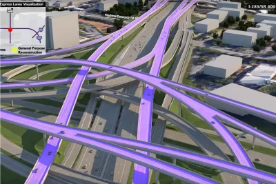
On Labor Day, Georgia’s Cobb County unexpectedly expressed support for a plan by the state Department of Transportation to expand Interstate 285 by adding toll lanes from South Atlanta Road to Henderson Road. As Josh Green explains in Urbanize Atlanta, “The project would cross three counties (Cobb, Fulton, and DeKalb) and the jurisdictions of several cities (Smyrna, Sandy Springs, Dunwoody, Brookhaven, Chamblee, Doraville, and Tucker).”
The article notes that “Another intent of the express lanes project, as GDOT has stressed from inception, is to provide mobility choices (and more reliable trip times) for metro Atlantans.” But the proposal, first revealed in 2019, does not add any new rail lines. Instead, “public transit providers that already operate buses and other vehicles in the corridor—MARTA, Xpress, and ‘state-registered vanpools’—will be able to use the new lanes for free, with no additional costs to riders, according to GDOT.” Pricing on the toll lanes will adjust in real time based on traffic conditions. GDOT estimates the toll lanes will be completed in 2032.
FULL STORY: Cobb County expresses support for huge system of elevated highways

Georgia's $11 Billion Road-Building Program Evolves
Recently announced changes to a massive road-building program in Georgia will shift moves projects aimed at improvements for the trucking industry earlier onto the calendar, while pushing back projects located closer to Atlanta.
Georgia DOT Takes $4.6 Billion Highway Expansion Plan on the Road
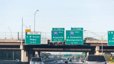
The Georgia Department of Transportation held a series of public meetings this month to reveal details of a plan to add toll lanes to I-285 and Georgia 400 outside Atlanta.
Positive Early Returns for Atlanta's Northwest Corridor Express Lanes
About 30 miles of toll lanes (called Express Lanes in the parlance of toll lane politics) on I-75 and I-575 in Cobb and Cherokee counties have been open for month.

Alabama: Trump Terminates Settlements for Black Communities Harmed By Raw Sewage
Trump deemed the landmark civil rights agreement “illegal DEI and environmental justice policy.”

Planetizen Federal Action Tracker
A weekly monitor of how Trump’s orders and actions are impacting planners and planning in America.

The 120 Year Old Tiny Home Villages That Sheltered San Francisco’s Earthquake Refugees
More than a century ago, San Francisco mobilized to house thousands of residents displaced by the 1906 earthquake. Could their strategy offer a model for the present?

Ken Jennings Launches Transit Web Series
The Jeopardy champ wants you to ride public transit.

BLM To Rescind Public Lands Rule
The change will downgrade conservation, once again putting federal land at risk for mining and other extractive uses.

Indy Neighborhood Group Builds Temporary Multi-Use Path
Community members, aided in part by funding from the city, repurposed a vehicle lane to create a protected bike and pedestrian path for the summer season.
Urban Design for Planners 1: Software Tools
This six-course series explores essential urban design concepts using open source software and equips planners with the tools they need to participate fully in the urban design process.
Planning for Universal Design
Learn the tools for implementing Universal Design in planning regulations.
Clanton & Associates, Inc.
Jessamine County Fiscal Court
Institute for Housing and Urban Development Studies (IHS)
City of Grandview
Harvard GSD Executive Education
Toledo-Lucas County Plan Commissions
Salt Lake City
NYU Wagner Graduate School of Public Service