


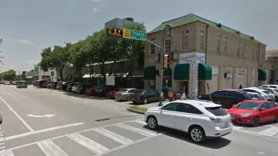
The ForwardDallas initiative is attempting for the Holy Grail of planning: development certainty.

The Dallas Development Code was written in 1965 and last updated in 1987, but the city’s Planning and Urban Design Department has been hard at work on an update—including “drafting a comprehensive future land use map, and digitizing boxes of paper records,” according to an article by April Towery for CandysDirt.com.
The future land use map overhaul, called ForwardDallas, launched in 2021 and is now under the leadership of Dallas planning director Julia Ryan, who has been at the helm of the department for about a year. The article devotes significant ink to allowing Ryan to discuss the challenges facing planning in Dallas, as well as the solutions enabled by ForwardDallas.
One of the key goals of ForwardDallas, according to the article, is reducing the city’s backlog of project approvals. Ryan says some of the city’s backlogs can be addressed with improved zoning—such as the city’s large amount of planning developments. “Having more than 1,200 [planned developments] is absurd. The more we can simplify zoning and increase what can be built by right, the better we can prevent [a permitting backlog] from happening again,” says Ryan, as quoted in the article.
FULL STORY: Dallas, We Have a Plan: Zoning Could Get Easier And Faster, Says Director of Planning and Urban Design

Dallas Exploring Parking Requirement Reform
Dallas relies on a formula introduced in 1965 to determine parking requirements for new developments, but city planners are studying how to update the city's development code for the future.

Dallas Launches New Comprehensive Plan Process—15 Years After ForwardDallas
The city of Dallas adopted the ForwardDallas plan in 2006, setting a grand ambition for a more walkable, transit-friendly city. Some of the work toward that vision will have to continue with the next comprehensive plan.

Dallas' First-Ever Strategic Mobility Plan Ties Land Use to New Transportation Ideas
The Connect Dallas Strategic Mobility Plan is open for public comment. Expect more big plans from Dallas soon—the ForwardDallas! comprehensive plan update will also kick off this year.

Alabama: Trump Terminates Settlements for Black Communities Harmed By Raw Sewage
Trump deemed the landmark civil rights agreement “illegal DEI and environmental justice policy.”

Planetizen Federal Action Tracker
A weekly monitor of how Trump’s orders and actions are impacting planners and planning in America.

The 120 Year Old Tiny Home Villages That Sheltered San Francisco’s Earthquake Refugees
More than a century ago, San Francisco mobilized to house thousands of residents displaced by the 1906 earthquake. Could their strategy offer a model for the present?

Ken Jennings Launches Transit Web Series
The Jeopardy champ wants you to ride public transit.

BLM To Rescind Public Lands Rule
The change will downgrade conservation, once again putting federal land at risk for mining and other extractive uses.

Indy Neighborhood Group Builds Temporary Multi-Use Path
Community members, aided in part by funding from the city, repurposed a vehicle lane to create a protected bike and pedestrian path for the summer season.
Urban Design for Planners 1: Software Tools
This six-course series explores essential urban design concepts using open source software and equips planners with the tools they need to participate fully in the urban design process.
Planning for Universal Design
Learn the tools for implementing Universal Design in planning regulations.
Clanton & Associates, Inc.
Jessamine County Fiscal Court
Institute for Housing and Urban Development Studies (IHS)
City of Grandview
Harvard GSD Executive Education
Toledo-Lucas County Plan Commissions
Salt Lake City
NYU Wagner Graduate School of Public Service