


Trails play a vital role in encouraging and facilitating outdoor recreation that contributes to the health and well-being of residents and visitors alike.

Are trails just lines randomly drawn on maps? While some people may perceive them this way, trail planners would most certainly disagree because of the thoughtfulness and care with which they approach their work. Trail planning is an underappreciated field that is complex and challenging. Aside from the few publications dedicated to trails, little is written about trail planning and the planners who are devoted to this increasingly important work due to the growing popularity of trails. According to recent Outdoor Participation Reports released by the Outdoor Industry Association, trail running, hiking, and mountain biking are among the most popular outdoor activities in the U.S. in terms of both participation rate and frequency of participation.
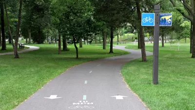
Recognizing that trails are critical components of the region’s park and recreation system, the Los Angeles County Department of Parks and Recreation (DPR) has been involved in trail planning, development, and maintenance for a long time. A dedicated Trails Planning Section works on a wide range of multi-use trail planning projects that serve hikers, equestrians, and mountain bikers in a variety of settings, including rural, suburban, and urban areas.
DPR is responsible for master planning the county’s regional trail system, which is mapped and included in the Parks and Recreation Element of the L.A. County General Plan. It also maintains the Trails Manual, which provides guidance on trail planning, design, development, operations, and maintenance. In addition, the Trails Planning Section has completed trails master plans for various areas, including Castaic and Santa Susana Mountains, located in the northern part of the county.
DPR has also developed an updated trails website and a new Trails LA County mobile app. The website and new mobile app promote the use of trails and inform the public of the value and importance of stewardship, conservation, and habitat restoration of open space. With its enhanced functionalities, the website is intended to be the go-to online resource for the public to find official trail information throughout the county, while the new mobile app provides an on-the-go experience. Both the website and app offer digital tools, including information on real-time alerts, maps, weather, trail length, elevation, difficulty level, rest stops, picnic locations, and much more.
For more information, please visit the Trails LA County website and read this article.
FULL STORY: County Parks, Recreation Encourages Use of Public Trails


Public and Private Collaboration Advances Park Development in Houston
Houston may be known to some as a concrete jungle, but its greenspaces continue to expand thanks to combined support from the public, private, and philanthropic sectors.

After the Fires: Challenges and Efforts to Heal LA’s Parks and Trails
The recent LA wildfires have devastated parks and trails, with recovery efforts requiring extended closures, collaborative restoration plans, and community support to address extensive damage and long-term risks like landslides.
How to Make Greenways Better
Adding amenities such as public restrooms and shade trees can make greenways like Detroit’s Joe Louis Greenway more inviting and comfortable for their users.

Alabama: Trump Terminates Settlements for Black Communities Harmed By Raw Sewage
Trump deemed the landmark civil rights agreement “illegal DEI and environmental justice policy.”

Planetizen Federal Action Tracker
A weekly monitor of how Trump’s orders and actions are impacting planners and planning in America.

The 120 Year Old Tiny Home Villages That Sheltered San Francisco’s Earthquake Refugees
More than a century ago, San Francisco mobilized to house thousands of residents displaced by the 1906 earthquake. Could their strategy offer a model for the present?

Indy Neighborhood Group Builds Temporary Multi-Use Path
Community members, aided in part by funding from the city, repurposed a vehicle lane to create a protected bike and pedestrian path for the summer season.

Congestion Pricing Drops Holland Tunnel Delays by 65 Percent
New York City’s contentious tolling program has yielded improved traffic and roughly $100 million in revenue for the MTA.

In Both Crashes and Crime, Public Transportation is Far Safer than Driving
Contrary to popular assumptions, public transportation has far lower crash and crime rates than automobile travel. For safer communities, improve and encourage transit travel.
Urban Design for Planners 1: Software Tools
This six-course series explores essential urban design concepts using open source software and equips planners with the tools they need to participate fully in the urban design process.
Planning for Universal Design
Learn the tools for implementing Universal Design in planning regulations.
Clanton & Associates, Inc.
Jessamine County Fiscal Court
Institute for Housing and Urban Development Studies (IHS)
City of Grandview
Harvard GSD Executive Education
Toledo-Lucas County Plan Commissions
Salt Lake City
NYU Wagner Graduate School of Public Service