


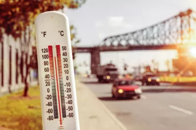
The California Healthy Places Index: Extreme Heat Edition is a tool which provides datasets on projected heat exposure for California, including place-based indicators measuring community conditions and sensitive populations.
The Healthy Places Index (HPI), a resource developed by the Public Health Alliance of Southern California, is well-known as a powerful tool that can be used to explore community conditions that predict life expectancy, compare and rank scores at multiple California geographies, and learn about concrete and actionable policy solutions.
There is now the Extreme Heat Edition of the HPI which is developed by the Public Health Alliance in partnership with the UCLA Luskin Center for Innovation. This new tool provides datasets on projected heat exposure for California, including place-based indicators measuring community conditions and sensitive populations. It also provides a list of resources and funding opportunities that can be used to address extreme heat.
Specifically, the tool can be used to:
- Understand underlying heat vulnerability and resilience characteristics of a community
- Identify resources to mitigate adverse effects of extreme heat
- Prioritize public and private investments, resources and programs
To learn more about the methodology and capabilities of the HPI: Extreme Heat Edition, please review the technical report.
FULL STORY: New Online Mapping Tool Helps California Prepare for Extreme Heat


Planting Relief: Tackling Las Vegas Heat One Tree at a Time
Nevada Plants, a Las Vegas-based nonprofit, is combating the city’s extreme urban heat by giving away trees to residents in underserved neighborhoods, promoting shade, sustainability, and community health.
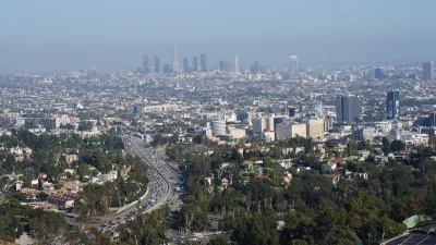
Updating LA’s Tree Rules Could Bring More Shade to Underserved Neighborhoods
A new USC study finds that relaxing Los Angeles’ outdated tree planting guidelines could significantly expand urban tree canopy and reduce shade disparities in lower-income neighborhoods, though infrastructure investments are also needed.

Public Parks as Climate Resilience Tools
Designed with green infrastructure, parks can mitigate flooding, reduce urban heat, and enhance climate resilience, offering cost-effective solutions to environmental challenges while benefiting communities.

Alabama: Trump Terminates Settlements for Black Communities Harmed By Raw Sewage
Trump deemed the landmark civil rights agreement “illegal DEI and environmental justice policy.”

Planetizen Federal Action Tracker
A weekly monitor of how Trump’s orders and actions are impacting planners and planning in America.

The 120 Year Old Tiny Home Villages That Sheltered San Francisco’s Earthquake Refugees
More than a century ago, San Francisco mobilized to house thousands of residents displaced by the 1906 earthquake. Could their strategy offer a model for the present?

Ken Jennings Launches Transit Web Series
The Jeopardy champ wants you to ride public transit.

BLM To Rescind Public Lands Rule
The change will downgrade conservation, once again putting federal land at risk for mining and other extractive uses.

Indy Neighborhood Group Builds Temporary Multi-Use Path
Community members, aided in part by funding from the city, repurposed a vehicle lane to create a protected bike and pedestrian path for the summer season.
Urban Design for Planners 1: Software Tools
This six-course series explores essential urban design concepts using open source software and equips planners with the tools they need to participate fully in the urban design process.
Planning for Universal Design
Learn the tools for implementing Universal Design in planning regulations.
Clanton & Associates, Inc.
Jessamine County Fiscal Court
Institute for Housing and Urban Development Studies (IHS)
City of Grandview
Harvard GSD Executive Education
Toledo-Lucas County Plan Commissions
Salt Lake City
NYU Wagner Graduate School of Public Service