


As more urban surfaces are developed and covered with impermeable materials, the importance of green infrastructure like bioswales and permeable pavement is growing.
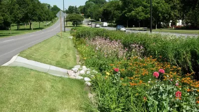
According to an article by Shaun McGillis, “In cities across the US, roads, rooftops, parking lots, sidewalks and driveways increased by an average of 326,000 hectares per year between 2012 and 2017.” These impermeable surfaces raise flood risks, but “The introduction of green infrastructures (GI), such as bioswales with permeable surfaces, has provided municipalities with a new tool to manage flood risk associated with rainfall.”
A new study from Portland State University analyzed the distribution of GI in three cities to evaluate whether it is distributed equitably.
According to the paper's lead author, Arun Pallathadka, a Ph.D. student in the Earth, Environment and Society program at Portland State, the research team found that the placement of GI in each of the cities inconsistently overlapped with areas prone to rainwater flooding, and non-white and low-income populations were more vulnerable to flood risk. Portland and Phoenix have increased investments in GI in neighborhoods with higher populations of non-white and low-income residents, marking a transition to more equitable flood risk management. In Atlanta, the risk of rainwater flooding was relatively low for non-white and low-income residents, though there was a substantial disparity in GI coverage.
As McGillis writes, “The methods deployed by the team provide cities with a novel approach to assessing the need for GI in neighborhoods prone to flooding associated with rainwater while also planning for the equitable distribution of those resources as they move ahead under the threat of increasing extreme precipitation events associated with a warming planet.”
FULL STORY: Rain, floods and green infrastructure: are cities mitigating the hazards equitably?


Flood Resilience Through Green Infrastructure
Cities like New York and Los Angeles are moving to build green infrastructure as the need for spongier urban spaces becomes more apparent.
Designing Permeable Cities for Drought Resilience
Take a kayak trip on the Los Angeles River with KQED science reporter Amy Standen to understand why cities were built on the premise of endless potable water and how we can build cities sustainably in regions that receive low rainfall.
Could Permeable Pavement Ease Flooding in New York City?
It can’t help cities control the weather, but by slowing the flow of stormwater, permeable pavement can lessen flooding from big storms.

Americans May Be Stuck — But Why?
Americans are moving a lot less than they once did, and that is a problem. While Yoni Applebaum, in his highly-publicized article Stuck, gets the reasons badly wrong, it's still important to ask: why are we moving so much less than before?

Using Old Oil and Gas Wells for Green Energy Storage
Penn State researchers have found that repurposing abandoned oil and gas wells for geothermal-assisted compressed-air energy storage can boost efficiency, reduce environmental risks, and support clean energy and job transitions.
Placekeeping: Setting a New Precedent for City Planners
How a preservation-based approach to redevelopment and urban design can prevent displacement and honor legacy communities.

San Francisco’s Muni Ridership Grew in 2024
The system saw its highest ridership since before the Covid-19 pandemic, but faces a severe budget shortage in the coming year.

Colorado Lawmakers Move to Protect BRT Funding
In the face of potential federal funding cuts, CDOT leaders reasserted their commitment to planned bus rapid transit projects.

Safe Streets Funding in Jeopardy
The Trump administration is specifically targeting bike infrastructure and other road safety projects in its funding cuts.
Urban Design for Planners 1: Software Tools
This six-course series explores essential urban design concepts using open source software and equips planners with the tools they need to participate fully in the urban design process.
Planning for Universal Design
Learn the tools for implementing Universal Design in planning regulations.
Heyer Gruel & Associates PA
City of Moreno Valley
Institute for Housing and Urban Development Studies (IHS)
City of Grandview
Harvard GSD Executive Education
Salt Lake City
NYU Wagner Graduate School of Public Service
City of Cambridge, Maryland