


The agency is seeking to execute joint development agreements to support more density near transit stations and boost affordable housing production.
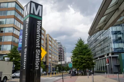
The Washington Metropolitan Area Transit Authority (Metro) wants to encourage transit-oriented development near its stations, reports John Aaron. "The agency hopes to execute new joint development agreements at 20 more stations in the next 10 years."
According to Liz Price, Metro’s vice president of real estate and parking, "Joint development agreements are not new to Metro, which has seen 55 buildings built at 30 stations since Metro opened in the 1970s."
Overall, the report says there are development opportunities at 40 stations — there are 91 in the system currently — totaling more than 500 acres, which could translate to 31 million square feet of new development and 26,000 new housing units.
Per Metro's strategic plan, the agency aims to "support higher density, mixed-use development," "secure infrastructure investments," "maximize economic development," and "support transit operations" with increased ridership and revenue. As Aaron notes, "Price also said that while the strategic planning process predates the pandemic, income from the developments would help Metro address potential financial shortfalls in the future."
FULL STORY: Metro looks to accelerate development near stations


Massachusetts TOD Law Yielding Results
While some cities are fighting the state’s push to increase density near transit, others are already breaking ground on multifamily projects that will bring hundreds of new housing units online.

Pittsburgh Mayor Proposes Zoning Changes to Curb Housing Shortage
The mayor’s plan includes legalizing ADUs in single-family neighborhoods, eliminating parking requirements, and adding new affordability requirements to buildings with over 20 units.
Can Zoning Reform Save Pittsburgh’s Affordable Housing?
With home sale prices growing faster than anywhere in the country, the Steel City could enact major reforms to boost density and lower housing costs.

Alabama: Trump Terminates Settlements for Black Communities Harmed By Raw Sewage
Trump deemed the landmark civil rights agreement “illegal DEI and environmental justice policy.”

Planetizen Federal Action Tracker
A weekly monitor of how Trump’s orders and actions are impacting planners and planning in America.

The 120 Year Old Tiny Home Villages That Sheltered San Francisco’s Earthquake Refugees
More than a century ago, San Francisco mobilized to house thousands of residents displaced by the 1906 earthquake. Could their strategy offer a model for the present?

Ken Jennings Launches Transit Web Series
The Jeopardy champ wants you to ride public transit.

BLM To Rescind Public Lands Rule
The change will downgrade conservation, once again putting federal land at risk for mining and other extractive uses.

Indy Neighborhood Group Builds Temporary Multi-Use Path
Community members, aided in part by funding from the city, repurposed a vehicle lane to create a protected bike and pedestrian path for the summer season.
Urban Design for Planners 1: Software Tools
This six-course series explores essential urban design concepts using open source software and equips planners with the tools they need to participate fully in the urban design process.
Planning for Universal Design
Learn the tools for implementing Universal Design in planning regulations.
Clanton & Associates, Inc.
Jessamine County Fiscal Court
Institute for Housing and Urban Development Studies (IHS)
City of Grandview
Harvard GSD Executive Education
Toledo-Lucas County Plan Commissions
Salt Lake City
NYU Wagner Graduate School of Public Service