


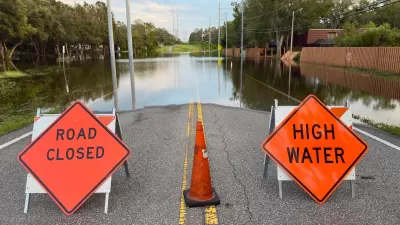
Changes to how FEMA calculates flood risk will assess risk at a home-by-home level, rather than estimating the same risk to all homes in the same floodplain.

FEMA's recent updates to its flood insurance program "will sharply raise the cost of flood insurance for many high-value homes in coastal states like Florida, sending dramatic new signals to current and potential waterfront homeowners about the risks they face from extreme weather fueled by climate change."
As reported by Jake Bittle, the new system "has triggered one of the most contentious climate adaptation debates in recent memory." While both sides agree that "the changes reflect a more accurate assessment of flood risk," some politicians "have petitioned FEMA to delay the rollout, hoping to protect their constituents from a decrease in property values that may accompany higher insurance premiums."
In its first update since the system was instituted in the 1960s, FEMA's risk analysis system now "estimates the individual risk facing each home, incorporating mountains of new data about water dynamics and the replacement cost for each home. The result is that homeowners will now pay premiums that reflect the specific flood risk for their home, rather than their general area." These changes rectify old inequities which forced some homeowners in an area to subsidize the costs to higher-risk homes.
"Still, this new rating system represents a partial fix to a program that has fundamental and longstanding issues." With heavily subsidized insurance rates, "The cost of insurance wasn’t high enough to discourage people from living in floodplains, so they just kept building near the water." This underfunding of the program was sharply felt "in 2005, when the claim payouts from Hurricanes Katrina and Rita plunged the program into a $20 billion debt hole that it still hasn’t emerged from."
"The changes from Risk Rating 2.0 are technical in nature, but they have serious political implications: The largest premium increases under the new system are for higher-value homes that are closer to the water." But politicians continue to advocate on behalf of wealthy homeowners. "[T]he spat over Risk Rating 2.0 centers around a question that will only become more relevant as climate change gets worse: How much should the public subsidize risky activity in economically important spheres like real estate?"
FULL STORY: FEMA’s new flood insurance plan is drawing the battle lines over climate adaptation

FEMA Suspends Flood Rebuilding Standard
The rule was designed to prevent the rebuilding of government-funded projects in areas prone to repeated floods.
FEMA Rule Calls for Updated Flood Modeling
Agency-funded projects will be required to be elevated at least 2 feet above the projected local flood level.
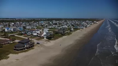
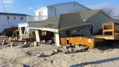
Looking for a Beach House? Check Your Risk First.
A new report from the insurance industry names the historic town of Galveston, Texas as the riskiest place to buy a beach house in the United States.

Alabama: Trump Terminates Settlements for Black Communities Harmed By Raw Sewage
Trump deemed the landmark civil rights agreement “illegal DEI and environmental justice policy.”

Planetizen Federal Action Tracker
A weekly monitor of how Trump’s orders and actions are impacting planners and planning in America.

The 120 Year Old Tiny Home Villages That Sheltered San Francisco’s Earthquake Refugees
More than a century ago, San Francisco mobilized to house thousands of residents displaced by the 1906 earthquake. Could their strategy offer a model for the present?

Ken Jennings Launches Transit Web Series
The Jeopardy champ wants you to ride public transit.

BLM To Rescind Public Lands Rule
The change will downgrade conservation, once again putting federal land at risk for mining and other extractive uses.

Indy Neighborhood Group Builds Temporary Multi-Use Path
Community members, aided in part by funding from the city, repurposed a vehicle lane to create a protected bike and pedestrian path for the summer season.
Urban Design for Planners 1: Software Tools
This six-course series explores essential urban design concepts using open source software and equips planners with the tools they need to participate fully in the urban design process.
Planning for Universal Design
Learn the tools for implementing Universal Design in planning regulations.
Clanton & Associates, Inc.
Jessamine County Fiscal Court
Institute for Housing and Urban Development Studies (IHS)
City of Grandview
Harvard GSD Executive Education
Toledo-Lucas County Plan Commissions
Salt Lake City
NYU Wagner Graduate School of Public Service