


New research highlights some of the ways planners can increase the social benefits and public acceptance of green stormwater infrastructure.
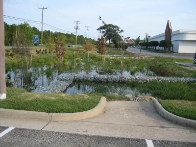
Green stormwater infrastructure (GSI) has become an increasingly common way for cities to rely less on traditional "gray" infrastructure such as curbs, gutters, and drains to mitigate flooding and stormwater runoff. GSI is especially useful in legacy cities, usually older and often shrinking in population, with combined sewer systems (CSS) that manage both stormwater and sewage and are easily overburdened during heavy rainfall, forcing polluted waters to divert into nearby waterways.
Most GSI projects utilize a combination of natural and designed elements in ways that highlight the water-trapping properties of vegetation. GSI projects vary in scale and function depending on where they are implemented. Common examples include tree trenches, which refer to vegetation planted in curbside gaps along impervious surfaces to prevent runoff from flooding streets and sidewalks; rain gardens, which are plant-filled concavities that collect and filter runoff; pervious pavements, which encourage infiltration directly where precipitation falls; and green roofs, which occur on flat-roofed buildings to minimize the speed and amount of runoff (Christman et al., 2018).

Beyond its essential functional value, GSI possesses important environmental, economic, and social benefits, ranging from improved air quality and increased property values to the promotion of a sense of community among residents. While urban planning professionals and researchers continue to recognize GSI's wide range of benefits, there remains a lack of understanding of how residents view the various GSI projects cropping up across the shrinking cities in which they live: are they community assets or the harbinger of new environmental concerns? This critical lack of understanding arguably stems from the fact that residents themselves are unsure of how to interpret GSI because it sometimes appears as neither wholly functional nor wholly aesthetic.
A research team from Rowan University, New Jersey, developed a set of questions to better understand how public perception, built and social environments, and different aspects of specific communities affect the long-term success of GSI projects. Does the geographic setting of these projects increase the recreational appeal of GSI projects? What determines GSI project appearance (e.g., signage, maintenance, or visibility)? How do location, surrounding land use, maintenance, recreational amenities, and visual appeal influence public perception of and interaction with GSI projects? How can planners increase the social benefits and acceptance of GSI? Based on extensive field observations in both Philadelphia, Pennsylvania and Camden, New Jersey, as well as a series of intercept interviews with residents, the Rowan research team pursued these questions in a recent article in Land (Meenar et al., 2020).
Methodology
The authors used the Philadelphia Water Department (PWD) Stormwater Map Viewer in addition to interactive maps of Camden, New Jersey's Green Infrastructure Project to identify 183 and 55 sites of GSI projects, respectively, which they then observed and recorded information regarding their settings, surrounding environments, uses, appearances, and recreational offerings. After completing a site visit, the team completed a site analysis form, coded photographs, and created GIS maps of the sites. Team members then ranked each site based on its recreational appeal (high, medium, or low), compared them against each other, and finalized them, with some sites requiring a second visit. Rankings were based on the presence, number, type, and design of available recreational features. The team also conducted a total of 50 intercept interviews: 40 in Philadelphia and ten in Camden. Participants answered questions related to discoverability, familiarity, accessibility, and interactivity of GSI projects, as well as about their overall evaluative perceptions of them.

Findings
Qualitative content analysis allowed the team to decipher results related to their guiding questions, wherein four major themes emerged. First, the types of GSI projects with the highest recreational appeal in Philadelphia were basins and porous paving, and those with the highest appeal in Camden were porous paving and cisterns. In both cities, projects situated in Designed Open Spaces had the highest appeal. Projects with low appeal were bumpouts and tree trenches for Philadelphia, and planters and downspouts for Camden. Projects situated in infrastructure-heavy areas rated low in appeal for both cities.
Second, low ratings in attractiveness for GSI projects in both cities were the result of poor maintenance, lack of signage, and low visibility. As the team argues, fewer signs mean less understanding of a project's environmental purpose, resulting in a higher likelihood of misuse and neglect. The relationship between signage and maintenance is especially important during winter months when green spaces tend to look less appealing than they do in the spring and summer months. The team proposes the same correlations for low visibility, particularly in Philadelphia, in that visitors are less likely to take care of a space if no one can easily see it.
Third, GSI projects with the highest amounts of trash and least signage unsurprisingly tended to be located in census tracts with high levels of potential disadvantage in both cities. The team followed an indicator of potential disadvantaged census tracts in the nine-county metropolitan region, created by the Delaware Valley Regional Planning Commission. The indicator includes nine factors, including racial minority, ethnic minority, youth, older adults, disabled, and low-income residents. While Philadelphia's census tracts ran the full range of low to high levels of potential disadvantage (five different levels in total), all of Camden's census tracts rated either high or medium-high.
Finally, when it came to visitor interaction, the team observed very few patrons directly interacting with the GSI projects (e.g., using public benches, weeding, or playing on equipment). The researchers again attributed this lack of sustained interaction to a lack of explanatory signage, as well as to other visual cues like benches or other seating arrangements that would signal to potential patrons that interaction was encouraged or allowed. Based on prior research, the team argued that placing GSI projects in areas with multiple land uses would bolster interaction. Indeed, according to their observations, the highest levels of interaction occurred in and around community-based settings (e.g., large parks and churches), where staff and volunteers took more pride in the appearance of the environments.
The intercept interviews provided solid evidence that confirmed the team's assumptions. Most respondents reported low levels of discoverability because of a lack of understanding of the purpose of GSI projects, a lack of visibility, or a lack of signage. This low discoverability was especially true for tree trenches and infiltration galleries. Next, respondents' levels of knowledge of various types of GSI projects and their function varied greatly, although many reported a basic understanding of the general concepts behind GSI and in particular rain barrels. Access to and interaction with GSI projects were consistently limited or difficult for many respondents, and those who did report moderate levels of access and/or interaction cited easy public access and amenities like shade trees, seating, sports features, and art installations. Some respondents were even inadvertently interacting with GSI projects like infiltration trenches because they had the outward appearance of parks or play areas. Respondents thus tended to highly rate GSI projects if they provided primary or secondary recreational benefits (e.g., basins as walking paths) or if they had strong aesthetic appeal (e.g., rain gardens with colorful seasonal flora). Overall, however, general sentiments among respondents focused on concern for the improper functioning of GSI projects, due to factors like middling maintenance, defective design, and problematic placement.
Implications
The Rowan University research team ultimately offers readers three important implications based on their findings. First, the location of a GSI project has a profound impact on its recreational appeal, so placing a project in a Designed Open Space like a park will likely increase appeal. Second, interpretive signage about and proper maintenance of GSI projects can prevent misuse and misunderstanding of the projects' environmental and social benefits. This second point is precisely why the team advocates for municipalities to develop specific maintenance and monitoring plans that ensure the proper functioning and use of GSI projects. Finally, public interaction is tied to a GSI project's visual appeal and placement in an area with multiple land uses (recreational, leisure, and residential) and high levels of walkability. Planners can therefore use these implications to retrofit existing GSI projects and design new ones.
GSI offers various environmental, economic, and social benefits; however, lack of knowledge of and community support for GSI-related projects can raise important social challenges, facilitate improper use, negatively impact maintenance, and ultimately hasten project failure. To read more about the relationship between GSI projects and residents' use and perception of them, read the research team's full article here.
Christopher Tirri is a graduate research assistant at Rowan University's Community Planning + Visualization Lab in the School of Earth and Environment.
Dr. Mahbubur Meenar is an Assistant Professor of Planning in the Department of Geography, Planning, and Sustainability at Rowan University.
References
Christman, Z., Meenar, M., Mandarano, L, & Hearing, K. (2018). Prioritizing suitable locations for green stormwater infrastructure based on social factors in Philadelphia. Land, 7(4), 1-17. doi:10.3390/land7040145
Meenar, M., Howell, J. P., Moulton, D., & Walsh, S. (2020). Green stormwater infrastructure planning in urban landscapes: Understanding context, appearance, meaning, and perception. Land, 9(12), 1-20. doi:10.3390/land9120534

South Los Angeles Park Offers Hidden Benefits
Not only does the redevelopment of a large section of Earvin Magic Johnson Park in Willowbrook offer much needed green space and new amenities, it also helps to conserve water and improve water quality.
Stormwater Credits Provide Incentives for Green Infrastructure
Most harmful stormwater originates on private property, and public agencies are looking for ways to entice property owners to implement more effective infrastructure.
Vancouver, Rain City
Vancouver has committed to green stormwater infrastructure by approving a Rain City Strategy that establishes an Integrated Stormwater Management Plan for each watershed in the city.

Manufactured Crisis: Losing the Nation’s Largest Source of Unsubsidized Affordable Housing
Manufactured housing communities have long been an affordable housing option for millions of people living in the U.S., but that affordability is disappearing rapidly. How did we get here?

Americans May Be Stuck — But Why?
Americans are moving a lot less than they once did, and that is a problem. While Yoni Applebaum, in his highly-publicized article Stuck, gets the reasons badly wrong, it's still important to ask: why are we moving so much less than before?

Using Old Oil and Gas Wells for Green Energy Storage
Penn State researchers have found that repurposing abandoned oil and gas wells for geothermal-assisted compressed-air energy storage can boost efficiency, reduce environmental risks, and support clean energy and job transitions.

Updating LA’s Tree Rules Could Bring More Shade to Underserved Neighborhoods
A new USC study finds that relaxing Los Angeles’ outdated tree planting guidelines could significantly expand urban tree canopy and reduce shade disparities in lower-income neighborhoods, though infrastructure investments are also needed.

California's Canal Solar Projects Aim to Conserve Resources and Expand Clean Energy
California’s Project Nexus has begun generating electricity from solar panels installed over irrigation canals, with researchers and state agencies exploring statewide expansion to conserve water and boost clean energy production.

HHS Staff Cuts Gut Energy Assistance Program
The full staff of a federal program that distributes heating and cooling assistance for low-income families was laid off, jeopardizing the program’s operations.
Urban Design for Planners 1: Software Tools
This six-course series explores essential urban design concepts using open source software and equips planners with the tools they need to participate fully in the urban design process.
Planning for Universal Design
Learn the tools for implementing Universal Design in planning regulations.
Heyer Gruel & Associates PA
City of Moreno Valley
Institute for Housing and Urban Development Studies (IHS)
City of Grandview
Harvard GSD Executive Education
Salt Lake City
NYU Wagner Graduate School of Public Service
City of Cambridge, Maryland