


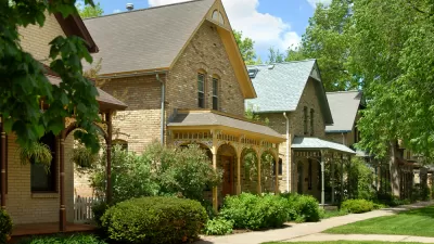
A proposal in Snohomish County, Washington could raise the lot coverage limits in medium density residential zones to allow for more usable square footage.

Under revised rules, Snohomish County could allow increased lot coverage and more flexible design in parts of the county's unincorporated urban growth areas. As reported by Stephen Fesler in The Urbanist, "county planners principally hope that the code amendments will solve lot coverage mismatches between zoning types, allow more flexible building and site design, and help development proposals reasonably achieve allowed zoning densities."
Lot coverage dictates how much of a lot can be covered by structures and has a major impact on how much usable square footage a lot can hold. Although sometimes associated with stormwater management and drainage, county planner Janet Wright addressed those concerns, stating in a briefing to the County Council "our drainage codes address mitigating stormwater runoff from…impervious surface areas and our code requires that projects implement low-impact development strategies where feasible." Wright also explained that "the current LDMR lot coverage maximum is unique and inexplicably lower than lower-density residential zones" and that increasing lot coverage "could bring more harmony of development patterns."
While the return on investment will ultimately drive site utilization, proponents of higher lot coverage predict that higher limits will "ensure that more projects fully use allowed zoning densities." The proposal is headed to a public hearing on March 3rd.
FULL STORY: Snohomish County Explores Higher Lot Coverage Allowances in Medium Density Zones for Housing


'Housing Choice' Approved in Massachusetts
The Housing Choice initiative, one of the country's most sweeping planning and development reforms to date, was included in a large economic development package approved by the Massachusetts Legislature earlier this week.
Missing Middle Density Will Take More Than Zoning Changes
Looking for change in the housing supply? "Don't stop at the zoning code and think you're done. There's so much work left to do."

How Massachusetts Got its Historic Planning Reform Moment
As reported earlier this month, the Massachusetts Legislature is poised to approve historic statewide land use reforms that would preempt local control of residential development. Here's a detailed account of how the state arrived at this moment.

Alabama: Trump Terminates Settlements for Black Communities Harmed By Raw Sewage
Trump deemed the landmark civil rights agreement “illegal DEI and environmental justice policy.”

Study: Maui’s Plan to Convert Vacation Rentals to Long-Term Housing Could Cause Nearly $1 Billion Economic Loss
The plan would reduce visitor accommodation by 25% resulting in 1,900 jobs lost.

Planetizen Federal Action Tracker
A weekly monitor of how Trump’s orders and actions are impacting planners and planning in America.

Waymo Gets Permission to Map SF’s Market Street
If allowed to operate on the traffic-restricted street, Waymo’s autonomous taxis would have a leg up over ride-hailing competitors — and counter the city’s efforts to grow bike and pedestrian on the thoroughfare.

Parklet Symposium Highlights the Success of Shared Spaces
Parklets got a boost during the Covid-19 pandemic, when the concept was translated to outdoor dining programs that offered restaurants a lifeline during the shutdown.

Federal Homelessness Agency Places Entire Staff on Leave
The U.S. Interagency Council on Homelessness is the only federal agency dedicated to preventing and ending homelessness.
Urban Design for Planners 1: Software Tools
This six-course series explores essential urban design concepts using open source software and equips planners with the tools they need to participate fully in the urban design process.
Planning for Universal Design
Learn the tools for implementing Universal Design in planning regulations.
Caltrans
Smith Gee Studio
Institute for Housing and Urban Development Studies (IHS)
City of Grandview
Harvard GSD Executive Education
Toledo-Lucas County Plan Commissions
Salt Lake City
NYU Wagner Graduate School of Public Service