


State climatologists are highly confident that heat waves are likely to trend upwards in future summers in Minnesota. To address extreme heat, researchers are identifying the factors that exacerbate extreme heat.

State climatologists are highly confident that heat waves are likely to trend upwards in future summers in the state, from 2025 onwards.
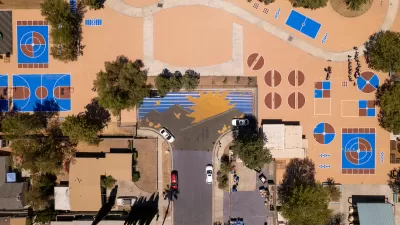
To create strategies to address extreme heat, researchers seek to identify the factors that exacerbate extreme heat. This research has shown that higher temperatures are amplified in areas with higher concentrations of pavement and impervious surface, as these areas tend to absorb residual heat and hold that heat longer than vegetation would. This effect is called the Urban Heat Island effect, or UHI. Buildings can block the wind, reducing a mitigating effect on the extreme heat. The four components that make up the UHI are lack of vegetation, a high percentage of impervious surfaces, residual heat from cars and mechanical cooling, and building shape and size.
Using remote sensing and satellite imagery, the Metropolitan Council has mapped an extreme heat event in the region, showing the land surface temperature during a three-day heat wave, at noon on July 22, 2016. The map shows areas of extreme heat within the urban core area of the metro, while it also shows that areas near parks and water bodies are significantly cooler. It is important to emphasize that the data consists of land surface temperature, as opposed to air temperature. Air temperature data can provide a better measure of potential extreme heat impacts on human health. The use of land surface temperature has ensured that this analysis has full metropolitan coverage. In addition, the use of land surface temperature can be helpful in identifying land use and built environment strategies to mitigate extreme heat in specific locations through a variety of site-specific interventions.
The Extreme Heat portion of the [Climate Vulnerability Assessment] focuses on correlations between heat and vegetation, impervious surface, and land use. Another portion of the CVA will focuses on human vulnerability to both localized flooding and extreme heat.
Why Focus on Extreme Heat?
- Though heat waves have not shown an upward trend, heat waves are more likely to occur in the future, beyond the year 2025, according the Minnesota State Climatology Office.
- Human vulnerability to extreme heat is of concern for many stakeholders in the region, particularly county public health departments and agency partners.
- The data created for this assessment allows us to investigate the relationship between the overall built and natural environment and the UHI effect.
Until now, no screening tool with regional coverage has been created to identify extreme heat through UHI. This tool may provide leverage in advancing analysis and more resources to help reduce the effects of extreme heat through proactive planning and on-the-ground implementation.
The Extreme Heat Story Map and the Extreme Heat Map Tool form the basis of this portion of the CVA project.
FULL STORY: Twin Cities Climate Vulnerability: Extreme Heat


Keeping Our Cool: Extreme Heat in the Twin Cities Region
A report discusses how rising temperatures affect the Twin Cities metropolitan area, and how those effects can be mitigated.
How to Beat Extreme Heat
Louisville, Kentucky has recently been named the "most rapidly growing urban heat island" in the U.S., but what led to this title? Jeff Byles traces how cities are becoming increasingly warm through a number of different factors, including economic.
Cool Pavements Show Promise as Part of Urban Climate Resilience Strategy
Results from a pilot project in Los Angeles show that cool pavement treatments can serve as a key tool in a city’s climate resilience strategy.

Alabama: Trump Terminates Settlements for Black Communities Harmed By Raw Sewage
Trump deemed the landmark civil rights agreement “illegal DEI and environmental justice policy.”

Planetizen Federal Action Tracker
A weekly monitor of how Trump’s orders and actions are impacting planners and planning in America.

The 120 Year Old Tiny Home Villages That Sheltered San Francisco’s Earthquake Refugees
More than a century ago, San Francisco mobilized to house thousands of residents displaced by the 1906 earthquake. Could their strategy offer a model for the present?

Downtown Pittsburgh Set to Gain 1,300 New Housing Units
Pittsburgh’s office buildings, many of which date back to the early 20th century, are prime candidates for conversion to housing.

Trump Administration Could Effectively End Housing Voucher Program
Federal officials are eyeing major cuts to the Section 8 program that helps millions of low-income households pay rent.

NRDC Releases State Transportation Scorecard
The Getting Transportation Right report highlights which states are making the most progress on reducing transportation emissions and improving access to clean transportation options.
Urban Design for Planners 1: Software Tools
This six-course series explores essential urban design concepts using open source software and equips planners with the tools they need to participate fully in the urban design process.
Planning for Universal Design
Learn the tools for implementing Universal Design in planning regulations.
Clanton & Associates, Inc.
Jessamine County Fiscal Court
Institute for Housing and Urban Development Studies (IHS)
City of Grandview
Harvard GSD Executive Education
Toledo-Lucas County Plan Commissions
Salt Lake City
NYU Wagner Graduate School of Public Service