


A data-driven approach is needed to figure out how the disease has spread in the islands and what can be done to contain it.
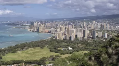
In this editorial, Karl Kim, a professor of urban and regional planning at the University of Hawaii, critiques and expresses his frustration with the state's response to the pandemic. As Hawaii struggles to get a handle on the crisis, he makes the case for much more data-sharing and a more data-driven approach to tackle COVID-19.
Kim indicates that there is "a crisis of data, analysis, and risk management" and that there needs to be "a renewed call-to-arms for data scientists, modelers, geo-spatial and statistical analysts to study, map, and figure out how the disease has spread and what can be done to contain it."
He recommends five actions that would help the State of Hawaii do a better job in fighting the pandemic: (1) establish a data clearinghouse for current integrated COVID-19 test, contact tracing, hospitalization, and medical insurance claims data, (2) perform focused quick analyses on the behavioral and locational attributes of those infected and spreading the disease, (3) form interdisciplinary teams of researchers, statisticians, and data scientists who are funded to conduct risk analyses but also review, critique, and share analytical capabilities, (4) integrate mapping, modeling, and risk assessment with planning and decision-making, and (5) ensure widespread community engagement in all phases of data collection, analysis, implementation, and evaluation of mitigation strategies.
Kim knows a thing or two about disasters and ways to mitigate and recover from them. He has spent much of his career studying disasters, and he is the executive director of the Pacific Urban Resilience Lab and the National Disaster Preparedness Training Center.
FULL STORY: Poor data management worsens Hawaii’s COVID-19 crisis


Planners and Pandemics: Identifying Problems and Providing Solutions
Planners are professional problem solvers. Let’s see how our methods can be applied to the COVID-19 pandemic.

Serpentine Maze: Pop-Up Parks in the Pandemic
If the combined effects of winter's cold and the pandemic has you bummed, check out this community-building exercise in the frozen North.
Nine Months Later: How the Pandemic Is Changing Communities
Planetizen shares the latest in a series of compendia tackling the effects of the pandemic, now and in the future, for cities and communities.

Alabama: Trump Terminates Settlements for Black Communities Harmed By Raw Sewage
Trump deemed the landmark civil rights agreement “illegal DEI and environmental justice policy.”

Planetizen Federal Action Tracker
A weekly monitor of how Trump’s orders and actions are impacting planners and planning in America.

The 120 Year Old Tiny Home Villages That Sheltered San Francisco’s Earthquake Refugees
More than a century ago, San Francisco mobilized to house thousands of residents displaced by the 1906 earthquake. Could their strategy offer a model for the present?

Ken Jennings Launches Transit Web Series
The Jeopardy champ wants you to ride public transit.

BLM To Rescind Public Lands Rule
The change will downgrade conservation, once again putting federal land at risk for mining and other extractive uses.

Indy Neighborhood Group Builds Temporary Multi-Use Path
Community members, aided in part by funding from the city, repurposed a vehicle lane to create a protected bike and pedestrian path for the summer season.
Urban Design for Planners 1: Software Tools
This six-course series explores essential urban design concepts using open source software and equips planners with the tools they need to participate fully in the urban design process.
Planning for Universal Design
Learn the tools for implementing Universal Design in planning regulations.
Clanton & Associates, Inc.
Jessamine County Fiscal Court
Institute for Housing and Urban Development Studies (IHS)
City of Grandview
Harvard GSD Executive Education
Toledo-Lucas County Plan Commissions
Salt Lake City
NYU Wagner Graduate School of Public Service