


Vision 2030 will update the award winning Vision 2020 New York City Comprehensive Waterfront Plan.
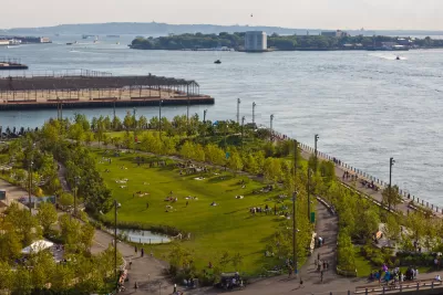
The city of New York is seeking public feedback on the Vision 2030 update of the New York City Comprehensive Plan, the first update since the Vision 2020 earned Daniel Burnham Award for a Comprehensive Plan from the American Planning Association in 2012.
The New York City Department of City Planning is mandated by a 2008 law to update the Comprehensive Waterfront Plan every ten years. The Vision 2030 update promises to make New York City’s 520 miles of waterfront more accessible, active, and resilient by building on the work of the Vision 2020 plan to provide public access the city's waterways, adapt the city's densely populated coastal areas to the effects of climate change, and support economic activity along the waterfront, among other goals.
The city is also hosting #WaterfrontWednesday virtual events to continue the public engagement process during the pandemic.
The Vision 2030 New York City Comprehensive Waterfront Plan is expected for completion by the end of 2020.

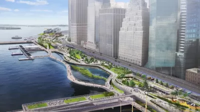
Lower Manhattan Climate Resilience Plan Released
The Financial District and Seaport Climate Resilience Master Plan will extend the shoreline in Lower Manhattan by up to 200 feet.
Finalists Selected for Governors Island Climate Research Center
Four teams will submit detailed proposals for a new climate research and education center on New York's Governors Island.

'Daylighting' Project to Restore Nature in the Big Apple
More cities are returning waterways to a more natural state—in some cases unearthing them from subterranean pipes in a process known as "daylighting." A new example can be found, perhaps surprisingly, in New York City.

Alabama: Trump Terminates Settlements for Black Communities Harmed By Raw Sewage
Trump deemed the landmark civil rights agreement “illegal DEI and environmental justice policy.”

Planetizen Federal Action Tracker
A weekly monitor of how Trump’s orders and actions are impacting planners and planning in America.

The 120 Year Old Tiny Home Villages That Sheltered San Francisco’s Earthquake Refugees
More than a century ago, San Francisco mobilized to house thousands of residents displaced by the 1906 earthquake. Could their strategy offer a model for the present?

BLM To Rescind Public Lands Rule
The change will downgrade conservation, once again putting federal land at risk for mining and other extractive uses.

Indy Neighborhood Group Builds Temporary Multi-Use Path
Community members, aided in part by funding from the city, repurposed a vehicle lane to create a protected bike and pedestrian path for the summer season.

Congestion Pricing Drops Holland Tunnel Delays by 65 Percent
New York City’s contentious tolling program has yielded improved traffic and roughly $100 million in revenue for the MTA.
Urban Design for Planners 1: Software Tools
This six-course series explores essential urban design concepts using open source software and equips planners with the tools they need to participate fully in the urban design process.
Planning for Universal Design
Learn the tools for implementing Universal Design in planning regulations.
Clanton & Associates, Inc.
Jessamine County Fiscal Court
Institute for Housing and Urban Development Studies (IHS)
City of Grandview
Harvard GSD Executive Education
Toledo-Lucas County Plan Commissions
Salt Lake City
NYU Wagner Graduate School of Public Service