


New research is quantifying the environmental consequences of land use patterns and water diversions in Northern Utah.
Brian Maffly shares news of new research led by Greg Carling, professor of Geology at Brigham Young University, quantifying the effects of a shrinking, drying Great Salt Lake.
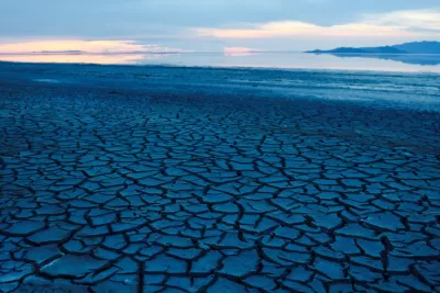
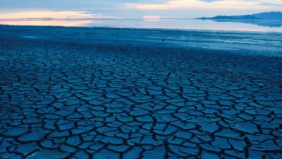
Upwind from northern Utah’s urban centers is a network of lakebeds, dried-up remnants of a vast prehistoric inland sea that dominated the region when the climate was much wetter and cooler that it is today.
Now, as western Utah becomes even drier — from drought, water diversions and climate change — these playas have become a major source of dust settling on Wasatch Front cities and their mountain water sources, according to new research conducted by Brigham Young University geologists.
According to the study, 90 percent of the dust comes from the exposed beds of the Great Salk Lake, Sevier Lake, and other valleys. That dust, large particulate matter PM10, causes problems for snowpack and water supply in the Wasatch Front region. An emerging field of research is connecting land use practices and water diversions to the effects of dust on water supply. The picture that has emerged is "alarming," explains Maffly.
FULL STORY: BYU study links shrinking Great Salt Lake, other vanishing water bodies to 90% of northern Utah’s dust

This Is What Really, Really Cheap Water Is Actually Costing Utah
The state's widespread practice of supplying unlimited untreated water to homes may be part of the reason it has to spend billions on a new pipeline and dam.
Shrinking Great Salt Lake Is a Ticking Time Bomb
Climate change and population growth are shrinking the Great Salt Lake. The environmental consequences are dire.

Virginia Data Centers Draining State’s Water Supply
Being the world’s largest data center hub is having a severe impact on local water resources.

Alabama: Trump Terminates Settlements for Black Communities Harmed By Raw Sewage
Trump deemed the landmark civil rights agreement “illegal DEI and environmental justice policy.”

Planetizen Federal Action Tracker
A weekly monitor of how Trump’s orders and actions are impacting planners and planning in America.

The 120 Year Old Tiny Home Villages That Sheltered San Francisco’s Earthquake Refugees
More than a century ago, San Francisco mobilized to house thousands of residents displaced by the 1906 earthquake. Could their strategy offer a model for the present?

Ken Jennings Launches Transit Web Series
The Jeopardy champ wants you to ride public transit.

BLM To Rescind Public Lands Rule
The change will downgrade conservation, once again putting federal land at risk for mining and other extractive uses.

Indy Neighborhood Group Builds Temporary Multi-Use Path
Community members, aided in part by funding from the city, repurposed a vehicle lane to create a protected bike and pedestrian path for the summer season.
Urban Design for Planners 1: Software Tools
This six-course series explores essential urban design concepts using open source software and equips planners with the tools they need to participate fully in the urban design process.
Planning for Universal Design
Learn the tools for implementing Universal Design in planning regulations.
Clanton & Associates, Inc.
Jessamine County Fiscal Court
Institute for Housing and Urban Development Studies (IHS)
City of Grandview
Harvard GSD Executive Education
Toledo-Lucas County Plan Commissions
Salt Lake City
NYU Wagner Graduate School of Public Service