


Though it stops well short of a citywide upzoning, the city of Tacoma has still expanded its planned development envelope by upzoning residential neighborhoods around the city.
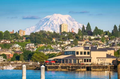
"In late September, the Tacoma City Council approved a large slate of areawide rezones and future land use map designation changes, which primarily affected residential properties," reports Stephen Fesler.
"The rezones and land use designation changes were included as part of the annual Comprehensive Plan update process for minor amendments, which were proposed in order to attain consistency between zoning and land use designations," adds Fesler.
According to Fesler, the changes amount to an upzoning, allowing more development intensity in residential areas in the city. "Where zoning of a site was less intensive or inconsistent with a future land use map (FLUM) designation type, the highest and most consistent implementing zoning type was proposed," according to Fesler. Still, Fesler warns, the effect fo the changes should not be overstated: "The changes adopted by the city council represent a small fraction of single-family areas and an even smaller fraction of the city, but they should help the city expand overall development capacity."
FULL STORY: Tacoma Quietly Rezoned Residential Areas in Latest Comp Plan Update


Minneapolis Draft Comprehensive Plan Would Allow Fourplexes in Single-Family Neighborhoods
If the rezoning of single-family neighborhoods succeeds in Minneapolis as part of its ongoing Comprehensive Plan process, we could be looking at one of the most ambitious pro-development zoning schemes in the country.

A Small Town Makes its First Zoning Update Since 1997
Mixed-use development and a floodplain overlay are the big-ticket items when the small community of Akron Borough in Pennsylvania recently updated its zoning code.
Pittsburgh Moves Ahead With Zoning Changes for University-Adjacent Neighborhood
The implementation of a new master plan for the neighborhood of Oakland, home to the University of Pittsburgh, is moving forward despite controversy and a contentious community engagement process.

Alabama: Trump Terminates Settlements for Black Communities Harmed By Raw Sewage
Trump deemed the landmark civil rights agreement “illegal DEI and environmental justice policy.”

Planetizen Federal Action Tracker
A weekly monitor of how Trump’s orders and actions are impacting planners and planning in America.

The 120 Year Old Tiny Home Villages That Sheltered San Francisco’s Earthquake Refugees
More than a century ago, San Francisco mobilized to house thousands of residents displaced by the 1906 earthquake. Could their strategy offer a model for the present?

Ken Jennings Launches Transit Web Series
The Jeopardy champ wants you to ride public transit.

BLM To Rescind Public Lands Rule
The change will downgrade conservation, once again putting federal land at risk for mining and other extractive uses.

Indy Neighborhood Group Builds Temporary Multi-Use Path
Community members, aided in part by funding from the city, repurposed a vehicle lane to create a protected bike and pedestrian path for the summer season.
Urban Design for Planners 1: Software Tools
This six-course series explores essential urban design concepts using open source software and equips planners with the tools they need to participate fully in the urban design process.
Planning for Universal Design
Learn the tools for implementing Universal Design in planning regulations.
Clanton & Associates, Inc.
Jessamine County Fiscal Court
Institute for Housing and Urban Development Studies (IHS)
City of Grandview
Harvard GSD Executive Education
Toledo-Lucas County Plan Commissions
Salt Lake City
NYU Wagner Graduate School of Public Service