


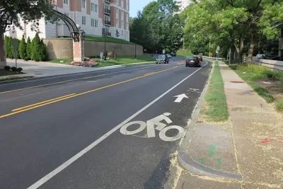
Before drafting a new Pedestrian Master Plan for Montgomery County, planners are creating a detailed inventory of street conditions by walking every single one fo the county's roads and streets.
Montgomery County, Maryland is in the process of developing a Pedestrian Master Plan, as reported in September 2019.
Now Sanjida Rangwala provides an update on the process, which includes a very notable step—actually a whole bunch of steps. To gather information on the safety of street conditions, Montgomery County employees are planning to walk every road and street in the county.
We wrote previously about the county’s #walkinghere campaign, which encourages residents to share the conditions of their walking trips on social media. Now county staff are documenting pedestrian experience throughout the county. They’re starting with major commercial areas, so your neighborhood might not have made it onto the survey yet. (Mine hasn’t). You can follow the progress of the map here.
Rangwala explains how the inventory of street conditions created by this survey process and provides photos to illustrate differences in classification. The article concludes with an appeal for safer streets in the county.
FULL STORY: Montgomery County planners will walk every street to see how safe they are for pedestrians

First for Montgomery County: A Pedestrian Master Plan
Planners in Montgomery County, Maryland, one of the most famous suburban regions in the country, will produce the first-ever pedestrian master plan for the county.
Pedestrian Planning in Response to Worsening Safety Data
Faced with rapidly deteriorating pedestrian safety statistics, Montgomery County in Maryland is getting to work on a new Pedestrian Plan, following closely on the heels of work completed for the county's Bicycle Master Plan.

Debunking Traffic Safety Myths as Pedestrian Fatalities Increase
Angie Schmitt, former editor at Streetsblog USA, has written a new book about pedestrian fatalities, which works to dispel some of the myths about traffic safety in the United States.

Alabama: Trump Terminates Settlements for Black Communities Harmed By Raw Sewage
Trump deemed the landmark civil rights agreement “illegal DEI and environmental justice policy.”

Planetizen Federal Action Tracker
A weekly monitor of how Trump’s orders and actions are impacting planners and planning in America.

Why Should We Subsidize Public Transportation?
Many public transit agencies face financial stress due to rising costs, declining fare revenue, and declining subsidies. Transit advocates must provide a strong business case for increasing public transit funding.

Blinded by the Light: When Brighter Headlights Decrease Safety
Bright LED headlights can create glare and reduce visibility for other drivers and pedestrians.

Study Links Covid and Poor Driving
The effects of the virus, including ‘brain fog,’ can make driving more difficult and dangerous.

Waymo Gets Permission to Map SF’s Market Street
If allowed to operate on the traffic-restricted street, Waymo’s autonomous taxis would have a leg up over ride-hailing competitors — and counter the city’s efforts to grow bike and pedestrian on the thoroughfare.
Urban Design for Planners 1: Software Tools
This six-course series explores essential urban design concepts using open source software and equips planners with the tools they need to participate fully in the urban design process.
Planning for Universal Design
Learn the tools for implementing Universal Design in planning regulations.
Caltrans
Smith Gee Studio
Institute for Housing and Urban Development Studies (IHS)
City of Grandview
Harvard GSD Executive Education
Toledo-Lucas County Plan Commissions
Salt Lake City
NYU Wagner Graduate School of Public Service