Ngoc Hong Nguyen of the University of Danang writes about a recent article he authored in the Journal of Planning Education and Research

Form-based codes (FBCs) are well-known to planners. Their advantage over conventional zoning is clear: real estate developers, lay people, planners and officials know in advance what the form of the city will be. Nonetheless, what most people may not know is another kind of regulatory planning process using generative codes—a process that guides city evolution in a stepwise manner. At each step, stakeholders improve the wholeness and coherence of the urban environment based on feedback from previous steps. Generative codes offer the virtues of instilling coherence, human scale, flexibility, and adaptability in the urban environment.
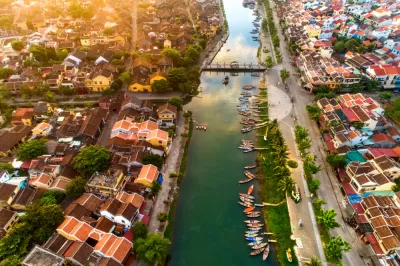
This generative process is promoted by Jane Jacobs, Christopher Alexander, Besim Hakim, Nikos Salingaros, Michael Mehaffy, and others. Such generative rules have dictated the development of traditional cities worldwide, whether the codes were written as a regulation—as in the case of Arabic-Islamic cities or through place-based norms for many of the other traditional towns worldwide. Of this latter category, the ancient town of Hoian, Vietnam serves as an exemplary model.
The generative process is primarily defined in the context of traditional settlements. Researchers describe what has already occurred in urban environments: they can observe discrete events in the timeline of urban development based on historical records. However, understanding the actual unfolding of the process in time and space is often difficult to fully grasp.
In my recent article in the Journal of Planning Education and Research, "Simulating the Generative Process of Urban Form: An Application Using OpenSim," I investigated the nature of the generative process, using Hoian and OpenSim as tools. I observed the dynamic evolution of the town in OpenSim. The generative process operating in OpenSim allows players to combine obscure historical events within the virtual environment and to do so "like assembling a giant puzzle"[i]. The OpenSim simulation allows the user to reexamine historical events in the case study and place them into the most reliable and probable sequence.
In this research I wanted to know what the components of the generative process are and how they function. Within the immersive environment of OpenSim, I was able to see the operationality of form and pattern language, as well as the pattern sequence. To do this I asked twenty-two participants to employ OpenSim to use patterns and urban properties as rules in the urban development process for the virtual town of Hoian. This approach was the first to employ a virtual environment to test and experiment with the generative process.
Through my work and that of my participants, I was able to establish patterns based on historical facts of Hoian from the 17th to 19th centuries. These patterns served as rules guiding the development of the town. Below are some selective steps of the development rules:
- Site selection. Select a site to build the town based on the advantages of location and ancient Cham wells.
- The Central. Market.Build the market at a prime location close to a wharf and possibly close to an ancient Cham well.
- The Tung Ban Hall and Tung Ban Pagoda. Build Tung Ban Hall and Tung Ban Pagoda as simple administrative and religious structures.
- The T-shape Town. The T-junction was formed by the intersection of Main Street and the street from the Hoian Village.
- Main Street. Build Main Street as the center of the town’s commercial and cultural life.
- The enhancement of Tung Ban Palace. Enhance Tung Ban Palace to become the main administrative building in town; embellish it with lavish decoration.
This research allowed me to posit some findings:
- The same set of generative rules can evolve diverse environments for a given town. In our work, participants built three different urban forms, each with unique qualities (and coherence) using the same set of rules.
- Three components of the generative process can serve as rules guiding the development process: pattern language, form language, and pattern sequence. They are what Eran Ben-Joseph[ii] calls place-based norms.
There are several practical benefits for planners that may be drawn from this research: i) Understand the three components of the generative process: pattern language, form language, and pattern sequence, and their operational characteristics, ii) Organize effective public participation in urban design through virtual environment simulation, such as OpenSim, and iii) Effect fine-tuning of the generative rules in order to achieve the best outcomes. It is worth noting that simulation may also be used for testing and building generative codes or generative modules within the context of a form-based code process.
Full Article Open Access Until December 8th, 2019
Dr. Ngoc Hong Nguyen is the Chair of the Faculty of Architecture at the University of Danang.
[i] Morgado, Leonel, João Varajão, Dalila Coelho, Clara Rodrigues, Chiara Sancin, and Valentina Castello. 2010. “The Attributes
and Advantages of Virtual Worlds for Real World Training.” The Journal of Virtual Worlds and Education 1(1):15–36
[ii] Ben-Joseph, Eran. 2005. The Code of the City: Standards and the Hidden Language of Place Making. Boston, MA: The MIT
Press.

Alabama: Trump Terminates Settlements for Black Communities Harmed By Raw Sewage
Trump deemed the landmark civil rights agreement “illegal DEI and environmental justice policy.”

Planetizen Federal Action Tracker
A weekly monitor of how Trump’s orders and actions are impacting planners and planning in America.

The 120 Year Old Tiny Home Villages That Sheltered San Francisco’s Earthquake Refugees
More than a century ago, San Francisco mobilized to house thousands of residents displaced by the 1906 earthquake. Could their strategy offer a model for the present?

Ken Jennings Launches Transit Web Series
The Jeopardy champ wants you to ride public transit.

BLM To Rescind Public Lands Rule
The change will downgrade conservation, once again putting federal land at risk for mining and other extractive uses.

Indy Neighborhood Group Builds Temporary Multi-Use Path
Community members, aided in part by funding from the city, repurposed a vehicle lane to create a protected bike and pedestrian path for the summer season.
Urban Design for Planners 1: Software Tools
This six-course series explores essential urban design concepts using open source software and equips planners with the tools they need to participate fully in the urban design process.
Planning for Universal Design
Learn the tools for implementing Universal Design in planning regulations.
Clanton & Associates, Inc.
Jessamine County Fiscal Court
Institute for Housing and Urban Development Studies (IHS)
City of Grandview
Harvard GSD Executive Education
Toledo-Lucas County Plan Commissions
Salt Lake City
NYU Wagner Graduate School of Public Service


