


Transportation planning will take on a much more safety-oriented focus according to the West Side Vision Zero Traffic Safety Plan announced last week.
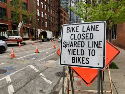
The city of Chicago has a new West Side Vision Zero Traffic Safety Plan, reports John Greenfield, who calls the new plan a milestone for the city's crash prevention policies.
Here's how Greenfield describes the plan's substance:
The Vision Zero West Side Plan includes 15 strategies to improve traffic and pedestrian safety in East and West Garfield Park, North Lawndale and Austin. The recommendations include safety improvements around transit stations; efforts to promote walking and biking to school and make it safer; the installation of pedestrian islands and other walking infrastructure and curb extensions in other locations in the communities, and a street remix for the pedestrian-hostile “Five Corners” intersection of Ogden, Pulaski and Cermak.
The article includes a lot of statements from officials to summarize the goals and expected results of the new plan, as well as a discussion by Greenfield of where the new plan fits into the context of the city's larger Vision Zero efforts since the city released its initial Vision Zero Chicago Action Plan in 2017.
FULL STORY: Chicago unveils its West Side Vision Zero Traffic Safety Plan


‘We Will Chicago’ Plan Adopted in the Windy City
Chicago has its first “comprehensive plan” since the 1960s, but without a land use map, the “We Will Chicago” plan is devoted more to laying out the issues and challenges facing the city than setting new policies.
Nascar Set to Race the Streets of Chicago Starting in 2023
Nascar races are a series of loops. Chicago has The Loop. Chicago also has a heated debate about traffic safety that probably doesn't have room for sponsored cars doing speeds upward of 100.
Planning for Congestion Relief
The third and final installment of Planetizen's examination of the role of the planning profession in both perpetuating and solving traffic congestion.

Alabama: Trump Terminates Settlements for Black Communities Harmed By Raw Sewage
Trump deemed the landmark civil rights agreement “illegal DEI and environmental justice policy.”

Planetizen Federal Action Tracker
A weekly monitor of how Trump’s orders and actions are impacting planners and planning in America.

The 120 Year Old Tiny Home Villages That Sheltered San Francisco’s Earthquake Refugees
More than a century ago, San Francisco mobilized to house thousands of residents displaced by the 1906 earthquake. Could their strategy offer a model for the present?

Ken Jennings Launches Transit Web Series
The Jeopardy champ wants you to ride public transit.

BLM To Rescind Public Lands Rule
The change will downgrade conservation, once again putting federal land at risk for mining and other extractive uses.

Indy Neighborhood Group Builds Temporary Multi-Use Path
Community members, aided in part by funding from the city, repurposed a vehicle lane to create a protected bike and pedestrian path for the summer season.
Urban Design for Planners 1: Software Tools
This six-course series explores essential urban design concepts using open source software and equips planners with the tools they need to participate fully in the urban design process.
Planning for Universal Design
Learn the tools for implementing Universal Design in planning regulations.
Clanton & Associates, Inc.
Jessamine County Fiscal Court
Institute for Housing and Urban Development Studies (IHS)
City of Grandview
Harvard GSD Executive Education
Toledo-Lucas County Plan Commissions
Salt Lake City
NYU Wagner Graduate School of Public Service