


Minneapolis wants more equity in its parks spending—and new plans are a key step in the process of delivering more equitable results.

"For the first time, the Minneapolis Parks and Recreation Board is writing comprehensive plans for every one of the city’s neighborhood parks, documents meant to guide development of the spaces for the next 20 to 30 years," reports Jessica Lee.
The comprehensive plans are necessitated by a change in parks budgeting established in 2016, when the city added an "Equity Matrix" to park funding decisions. The system was created "to reform a system that historically invested more money into the city’s more affluent, and whiter, neighborhoods," according to Lee.
"But with that new matrix in place, parks officials needed plans for how, exactly, to spend the money. That’s where the master plans for neighborhood parks come in," explains Lee.
The Minneapolis Parks and Recreation Board has been working on plans since 2016, along the way "[approving] long-range plans for neighborhood parks south of downtown and east of Interstate 35W [pdf], as well as those in the city’s urban core [pdf]. Then, in the spring of 2019, the board finalized the North Service Area Master Plan (which covers areas west of the Mississippi and north of Interstate 394) and the East of the River Park Master Plan (which pertains to northeast and southeast Minneapolis.)"
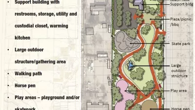
That's not even all the work that's underway at at various stages of the planning process, according to the article. Lee also updates the overall scope of the work and focuses on specific parks presenting more complex challenges as well.
FULL STORY: From pickleball to pollinators, people have a lot of thoughts about parks in southwest Minneapolis

Park Planning in a Pandemic
In pursuit of a grant for park development, Los Angeles County engages community members virtually to gather input and design a new park.

Development vs. Open Space at a Denver Golf Course
A developer just bought a Denver-area golf course in the hopes of some day rezoning the site for residential and commercial development. Open space advocates have other ideas, as does the city (for now).

When Does a Public Space Plan Rely Too Much on Pavement?
The debate leading up to the recent approval of the Arlington County, Virginia Public Spaces Master Plan reveals the competing pressures on park planning in 2019.

Alabama: Trump Terminates Settlements for Black Communities Harmed By Raw Sewage
Trump deemed the landmark civil rights agreement “illegal DEI and environmental justice policy.”

Planetizen Federal Action Tracker
A weekly monitor of how Trump’s orders and actions are impacting planners and planning in America.

The 120 Year Old Tiny Home Villages That Sheltered San Francisco’s Earthquake Refugees
More than a century ago, San Francisco mobilized to house thousands of residents displaced by the 1906 earthquake. Could their strategy offer a model for the present?

Ken Jennings Launches Transit Web Series
The Jeopardy champ wants you to ride public transit.

BLM To Rescind Public Lands Rule
The change will downgrade conservation, once again putting federal land at risk for mining and other extractive uses.

Indy Neighborhood Group Builds Temporary Multi-Use Path
Community members, aided in part by funding from the city, repurposed a vehicle lane to create a protected bike and pedestrian path for the summer season.
Urban Design for Planners 1: Software Tools
This six-course series explores essential urban design concepts using open source software and equips planners with the tools they need to participate fully in the urban design process.
Planning for Universal Design
Learn the tools for implementing Universal Design in planning regulations.
Clanton & Associates, Inc.
Jessamine County Fiscal Court
Institute for Housing and Urban Development Studies (IHS)
City of Grandview
Harvard GSD Executive Education
Toledo-Lucas County Plan Commissions
Salt Lake City
NYU Wagner Graduate School of Public Service