


Google Maps will now share data about how crowded buses and trains are likely to be.
Google has been collecting data on how many people are on trains and buses around the country, and now it's ready to share that data with Google Maps users. "Google is basing these details on past rides. For months, Google has been asking some people who use Google Maps to provide additional details about the level of crowdedness of their transit trips," Andrew J. Hawkins reports for The Verge. While these predictions won’t be based on current conditions they’re likely to improve as the app collects more data.
"In addition, Google Maps is also launching live traffic delays for buses in places where commuters don’t already have real-time information direct from local transit agencies," Hawkins reports. While many large American cities already provide this information to their riders, it could be a big help to folks riding buses in smaller communities.
These improvements to transit navigation, aren’t the only changes to Google’s navigation services, which have also added services for drivers and carpoolers.
FULL STORY: Google Maps is receiving major public transportation improvements


Suburban Detroit Achieves Long-Awaited Bus Service Expansion
Novi and Bloomfield Hills in Southeast Michigan will have transit service for the first time in 28 years.

The Bus Revolution Has Been Revised in Philadelphia
The Southeastern Pennsylvania Transportation Authority went back to the drawing board with its Bus Revolution system redesign after an initial round of feedback completed earlier this year.
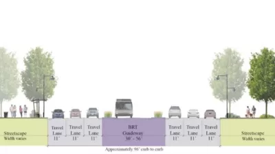
Fairfax County Makes Space for Bus Rapid Transit
A recent decision by the Fairfax, Virginia County Board of Supervisors will ensure that any widening of Route 7 will be reserved for bus rapid transit (BRT).

Alabama: Trump Terminates Settlements for Black Communities Harmed By Raw Sewage
Trump deemed the landmark civil rights agreement “illegal DEI and environmental justice policy.”

Planetizen Federal Action Tracker
A weekly monitor of how Trump’s orders and actions are impacting planners and planning in America.

The 120 Year Old Tiny Home Villages That Sheltered San Francisco’s Earthquake Refugees
More than a century ago, San Francisco mobilized to house thousands of residents displaced by the 1906 earthquake. Could their strategy offer a model for the present?

In Both Crashes and Crime, Public Transportation is Far Safer than Driving
Contrary to popular assumptions, public transportation has far lower crash and crime rates than automobile travel. For safer communities, improve and encourage transit travel.

Report: Zoning Reforms Should Complement Nashville’s Ambitious Transit Plan
Without reform, restrictive zoning codes will limit the impact of the city’s planned transit expansion and could exclude some of the residents who depend on transit the most.

Judge Orders Release of Frozen IRA, IIJA Funding
The decision is a victory for environmental groups who charged that freezing funds for critical infrastructure and disaster response programs caused “real and irreparable harm” to communities.
Urban Design for Planners 1: Software Tools
This six-course series explores essential urban design concepts using open source software and equips planners with the tools they need to participate fully in the urban design process.
Planning for Universal Design
Learn the tools for implementing Universal Design in planning regulations.
Clanton & Associates, Inc.
Jessamine County Fiscal Court
Institute for Housing and Urban Development Studies (IHS)
City of Grandview
Harvard GSD Executive Education
Toledo-Lucas County Plan Commissions
Salt Lake City
NYU Wagner Graduate School of Public Service