


Brookings buils on the findings of recent research about jobs densification in cities around the country to make a larger point about the benefits of proximity in urban design, as compared to sprawl.
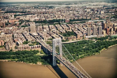
"New research from the Bass Center for Transformative Placemaking at Brookings confirms that when it comes to site selection, American businesses continue to value proximity."
Adie Tomer, Joseph W. Kane, and Lara Fishbane write to explain the findings of the research referenced above, tying transportation and land use planning to the discussion as the "ultimate enablers of proximity."
"The character of our urban form—including density, permitted use in buildings, and transportation designs—will either promote closer proximity or push economic activity further apart. And despite the best efforts of many business and civic leaders, the prevailing transportation model in the United States downplays distance and focuses too much on traffic," according to the article.
Earlier this month, Planetizen picked up the news of the research cited here, but the current article more explicitly ties the findings of the study to planning policies and more explicitly appeals for a shift toward less car-oriented sprawl.
"We propose a new model: prioritizing human-scale proximity and the shorter-distance travel it promotes," according to the article, before laying out a list of five benefits to more proximity and less sprawl, with more detail in the source article:
- Proximity promotes agglomeration, helping to grow industries and regional economies.
- Proximity requires less infrastructure per capita, reducing fiscal burdens on communities.
- Proximity offers more modal choice, making transportation more affordable and age-neutral.
- Proximity is essential to hitting carbon targets and developing more resilient places.
- Proximity incentivizes safer streets and supports a healthier population.
The article also includes one critical caveat: the proposal does not necessitate a Cobursian approach to urban development that would replicate skyscrapers all over urban areas. To get at the right mix of densities, the trio of writers suggests making better use of the new troves of transportation data available to planners.
FULL STORY: Connecting people by proximity: A better way to plan metro areas


Density and Disorder: The Imaginary Link
A recent article tries to tie public transit and walkability to social disorder — but in fact, sprawling Sunbelt cities like Memphis are as likely to have high crime rates as transit-rich metropolises such as New York and San Francisco.
Commentary: We Need a Return to the Adaptability of Traditional Urban Form
How the rigidity of modern suburban development fails to prepare cities for the future.

Commentary: Minimum Lot Sizes Drive Up Housing Costs
How making residential building requirements more flexible can ease the housing crisis and make neighborhoods more livable for more households.

Alabama: Trump Terminates Settlements for Black Communities Harmed By Raw Sewage
Trump deemed the landmark civil rights agreement “illegal DEI and environmental justice policy.”

Planetizen Federal Action Tracker
A weekly monitor of how Trump’s orders and actions are impacting planners and planning in America.

The 120 Year Old Tiny Home Villages That Sheltered San Francisco’s Earthquake Refugees
More than a century ago, San Francisco mobilized to house thousands of residents displaced by the 1906 earthquake. Could their strategy offer a model for the present?

High-Speed Rail Tracker
Smart Cities Dive follows high-speed rail developments around the country

Ken Jennings Launches Transit Web Series
The Jeopardy champ wants you to ride public transit.

BLM To Rescind Public Lands Rule
The change will downgrade conservation, once again putting federal land at risk for mining and other extractive uses.
Urban Design for Planners 1: Software Tools
This six-course series explores essential urban design concepts using open source software and equips planners with the tools they need to participate fully in the urban design process.
Planning for Universal Design
Learn the tools for implementing Universal Design in planning regulations.
Clanton & Associates, Inc.
Jessamine County Fiscal Court
Institute for Housing and Urban Development Studies (IHS)
City of Grandview
Harvard GSD Executive Education
Toledo-Lucas County Plan Commissions
Salt Lake City
NYU Wagner Graduate School of Public Service