


The applications for 3D technology in the field of planning are multiplying and diversifying.

It's difficult to find an industry untouched by 3D technology. Applying it to urban planning can help the parties cut costs, complete projects with greater efficiency, and more.
Here are some of the ways 3D printing and modeling technologies have changed what's possible for current and aspiring urban planners.
Building Bridges Without Human Laborers
Urban planning in areas along the water requires discussing how bridges factor into the city's design and help pedestrians and cars travel smoothly.
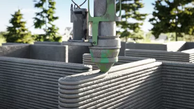
Amsterdam's Red Light District will soon have a 3D-printed footbridge made by robots. The company behind the project will also equip the bridge with sensors that collect data and inform future ideas for 3D bridges.
Not all 3D printing efforts happen without humans in the picture. But, this case substantially reduced the human labor needed because it required only a welding machine, industrial robots and specialty software.
Helping Solve the Homelessness Crisis
Research indicates that about 2% of the world's population is homeless, and a further 20% lack adequate housing. It's impossible to pin down the homelessness problem to a single cause, but unplanned or poorly planned urbanization is a culprit, as well as rising home costs. So, keeping residents comfortably housed and dealing with population increases in cities are two facets of responsible urban planning.
3D printing could tackle both of those aims. In one recent example, a designer named Yves Béhar plans to use 3D printing technology to create a community of homes for Latin American farmers that live on the equivalent of less than $200 per month.
The representatives working on this pioneering project believe that effectively addressing homelessness means looking beyond traditional methods of solving the problem. In this case, that means turning to 3D printing.
We're also seeing the first fully permitted 3D-printed homes begin to pop up across the United States, including a charming 350-square-foot abode designed by an Austin-based company This is an important step toward deploying low-cost housing at a larger scale.
Assisting Planners With Accurately Capturing the Dimensions of Physical Objects
City planners often communicate with other professionals instrumental to creating or improving a city, such as engineers and architects. When doing so, they often provide measurements of physical objects, such as additions to a building.
However, inaccurate measurements could slow down the construction, resulting in errors that make projects go over budget.
Fortunately, 3D laser scanning is a faster and more accurate way to measure dimensions compared to traditional methods. Moreover, using 3D laser scanning could avoid the need to revisit sites to take multiple measurements. Take Vineland, New Jersey, for example, where multiple firms are involved in the demolition and subsequent restructuring of the area surrounding the community's City Hall.
The engineering firm tasked with the laser-scanning project were awarded a $17,500 contract to aid city planners by showing 3D representations of possible ways to move forward with the project.
One example suggests connecting the second floor of City Hall with a pedestrian bridge stretching to a nearby parking garage. Taking that approach would help people use more streamlined paths when traveling on foot. There are tradeoffs, of course — more pedestrian bridges mean, potentially, a less vibrant and active streetscape. Nevertheless, 3D modeling helps architects, city planners and the general public better visualize, understand and plan for any proposed changes.
Keeping Residents Clued In About Upcoming City Planning Endeavors
When city planners take the time to engage with members of the public and inform them about what's in the works, residents might be more likely to perceive the changes with excitement instead of protesting them or feeling confused about what's on the horizon.
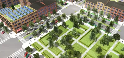
In 2014, city planners in Stockholm decided to communicate with residents of the Swedish capital by giving them access to an interactive 3D modeling interface that provided information about ongoing changes in the city. The touch screen display, located in Stockholm's Culture House, combines 3D models with geographic information systems (GIS) data already possessed by municipal representatives.
Applying such technology to other cities around the globe could be instrumental in helping citizens feel more informed about, and therefore more receptive to, the changes happening in their neighborhoods. City planners could also do something similar and use proposed 3D models to encourage residents to chime in about different options under consideration by the planning board.
Boston is another city where planners combine two-dimensional GIS information with 3D models. The technology used there even lets people change the position of the sun and see how prospective buildings would impact shading in an area. City planning officials aim to make the model widely available and user-friendly to foster better engagement between city officials and the residents affected by alterations.
Mitigating the Impacts of Urban Overheating
An urban heat island is an area in a city that's substantially warmer than the surrounding rural areas due to human activities. Urban planners have numerous techniques at their disposal to reduce the effects of urban heat islands and the associated overheating. They include planting vegetative layers on rooftops and using specialty pavement materials that reflect more light than conventional choices.
City planners in Sydney, Australia use a 3D modeling tool that equips them to explore the payoffs of particular urban heating mitigation strategies. Users work with the 3D software by overlaying things like trees onto segments of the city to visualize the possible results. They can benefit from this 3D modeling solution without having technical backgrounds, too.
3D Printing and Modeling Could Make Enhanced Cities More Feasible
The examples here provide a glimpse of the promise associated with 3D printing and models as related to urban planning.
These innovations do not mean that city planners can disregard all their previous methods, but these possibilities give them new options to ponder when determining how to meet needs while designing cities for current and future inhabitants.


4 Urban Analytics and Modeling Trends to Watch in 2020
Urban analytics has the potential to benefit both planners and the world. Here' are a few ways that new data-based approaches can open new levels of analysis and understanding.
Imagining Neighborhoods Filled with 3D Printed Homes
Gensler, along with partners in China, is exploring ways to implement 3D printing technology. It's time for planners to start letting their imaginations run wild with possibilities.
Oklahoma Lawmaker Looks to 3D Printing to Create Affordable Housing
Over a dozen U.S. states already permit 3D-printed homes, which can cost less and use fewer resources than conventional homes.
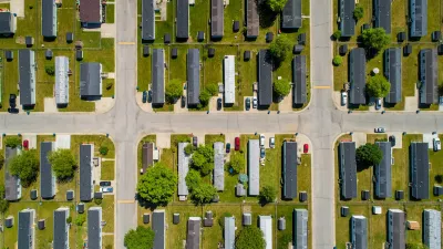
Manufactured Crisis: Losing the Nation’s Largest Source of Unsubsidized Affordable Housing
Manufactured housing communities have long been an affordable housing option for millions of people living in the U.S., but that affordability is disappearing rapidly. How did we get here?

Americans May Be Stuck — But Why?
Americans are moving a lot less than they once did, and that is a problem. While Yoni Applebaum, in his highly-publicized article Stuck, gets the reasons badly wrong, it's still important to ask: why are we moving so much less than before?

Research Shows More Roads = More Driving
A national study shows, once again, that increasing road supply induces additional vehicle travel, particularly over the long run.

Judge Halts Enforcement of Anti-Homeless Laws in Grants Pass
The Oregon city will be barred from enforcing two ordinances that prosecute unhoused residents until it increases capacity and accessibility at designated camping sites.

Advancing Sustainability in Los Angeles County Schools
The Los Angeles County Office of Education’s Green Schools Symposium brings together educators, students, and experts to advance sustainability in schools through innovative design, climate resilience strategies, and collaborative learning.

Using Old Oil and Gas Wells for Green Energy Storage
Penn State researchers have found that repurposing abandoned oil and gas wells for geothermal-assisted compressed-air energy storage can boost efficiency, reduce environmental risks, and support clean energy and job transitions.
Urban Design for Planners 1: Software Tools
This six-course series explores essential urban design concepts using open source software and equips planners with the tools they need to participate fully in the urban design process.
Planning for Universal Design
Learn the tools for implementing Universal Design in planning regulations.
City of Moreno Valley
Institute for Housing and Urban Development Studies (IHS)
City of Grandview
Harvard GSD Executive Education
NYU Wagner Graduate School of Public Service
City of Cambridge, Maryland
Newport County Development Council: Connect Greater Newport