


It is important to focus on forests rather than individual trees when evaluating trade-offs between infill and sprawled development.

Planners should generally focus on forests rather than individual trees. This is an important issue when evaluating trade-offs between urban infill and sprawled development. Infill tends to have more visible but smaller environmental impacts than sprawl. Comprehensive analysis often justifies displacing individual trees to allow development which protects regional forests or other types of open space.
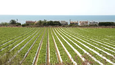
A typical two-adult family that locates in a walkable urban neighborhood uses far less land (10-30 units per acre, compared with 2-6 in suburbs), owns one rather than two vehicles, and makes half as many vehicle trips as they would in an automobile-oriented suburb. Consumer surveys indicate that a majority of households would prefer to live in a compact house in a walkable urban neighborhood than in sprawled, automobile-dependent areas. The table below lists some of the resulting benefits.
Compact Infill Benefits
Reduced Land Consumption |
Improved Accessibility |
Reduced Auto Use |
Overall, urban infill is far more resource-efficient than sprawl. Urban neighborhood residents produce about a third the carbon emissions as suburban residents (figure below), due to reduced automobile travel and more energy efficient buildings.

Another debate concerns trees. Opponents fight infill projects that displace trees, ignoring the much larger habitat losses that result from urban fringe development. For example, two recent local magazine articles, "Victoria’s Diminishing Urban Forest," and "Losing trees in Victoria: one mature tree equals 269 saplings," argued that urban development threatens our tree canopy, and criticized the 83-unit Bellewood Park project for displacing ten significant trees. The removal of one tree to build a downtown bike lane created a storm of angry protest signs, petitions, poems, and letters to the newspaper.
I certainly appreciate their intent. Trees are beautiful and enhance the environment, so it is good to promote urban forests. However, that does not require protecting every tree. Anti-infill advocates focus on a few, highly visible trees while ignoring much larger threats to forests, and they generally have nothing to lose. I've never heard homeowners protesting the cutting of trees that threaten their house, or motorist opposing tree removals needed to expand roads or parking lots. For example, the loss of 212 trees [pdf], including 182 Gerry Oaks [pdf], to expand a regional highway interchange raised virtually no opposition.
Methods described below can be used to evaluate these impacts.
Measuring Environmental Impacts
Land uses vary in their environmental values, including wildlife habitat, groundwater percolation and beauty. The most ecologically valuable lands are undisturbed natural openspaces, such as forests and shrub lands. Farmlands, urban parks, gardens and laws generally have less biological diversity, and heavy fertilizer and pesticide use reduce their habitat and groundwater recharge values. Buildings and pavement are impervious surfaces (they allow no groundwater percolation); they are ecologically sterile, although their environmental values can be enhanced with landscaping and the use of permeable materials. The table below rates the environmental values of various land uses.
Land Use Environmental Values
Land Use |
Environmental Impacts |
Values |
|
Undisturbed natural open space |
Wildlife habitat, groundwater recharge, beauty |
Highest |
|
Disturbed natural open space |
Wildlife habitat, groundwater recharge, beauty |
|
|
Farmlands |
Agricultural productivity, beauty |
|
|
Urban parks |
Wildlife habitat, groundwater recharge, beauty |
|
|
Urban gardens |
Wildlife habitat, agricultural productivity, groundwater recharge, beauty |
|
|
Lawns |
Beauty |
|
|
Gravel roads and pervious parking |
Groundwater recharge |
|
|
Landscaped roads and parking |
Wildlife habitat, beauty |
|
|
Buildings and pavement |
Ecologically sterile |
Lowest |
Natural open space, such as forests, provide the highest environmental values. Impervious surfaces, such as buildings, roads and parking facilities, provide the least environmental values.
Several studies have measured the portion of urban lands devoted to various land uses. For example, the figure below illustrates the portion of land devoted to streets, sidewalks, parking/driveways, and roofs in a typical North American community. Roads and parking facilities cover 10-25% of urban land, and more than half of all land in major commercial centers, far more than the portion of land devoted to buildings.
Impervious Surface Coverage (Arnold and Gibbons 1996)
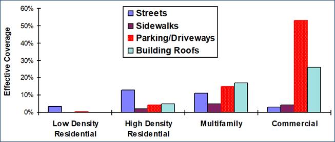
Roads, parking facilities and sidewalks represent a major portion of urban land area.
This indicates how vehicle ownership and use affect land use. As automobile ownership increases, more land must be paved for roads and parking, increasing impervious surface areas. These impacts are generally ignored. When purchasing a motor vehicle, consumers seldom consider the additional roads and parking facilities that they will need, and the environmental damages this will cause. Similarly, planners seldom quantify habitat preserved by policies and programs that reduce automobile ownership and encourage infill rather than sprawled development.
Various studies have measured the number of off-street parking spaces per motor vehicle or per capita in various urban areas.
- Estimating Parking Lot Footprints In The Upper Great Lakes Region Of The USA used detailed aerial photographs to count parking facilities in Illinois, Indiana, Michigan, and Wisconsin. The researchers found 2.5 to 3.0 non-residential off-street parking spaces per vehicle, with higher proportions in sprawled areas.
- Parking Spaces Outnumber Drivers 3-to-1, Drive Pollution and Warming, by Purdue research Bryan Pijanowski, found approximately 3 non-residential off-street parking spaces per vehicle in Tippecanoe County.
- Quantified Parking: Comprehensive Parking Inventories for Five U.S. Cities, by Eric Scharnhorst, for the Mortgage Bankers Association, estimated that per capita off-street parking spaces range from 1.4 in Philadelphia, 2.3 in Seattle, 7.5 in Des Moines, and 9.5 in Jackson, Wyoming.
- Parking Infrastructure: A Constraint on or Opportunity for Urban Redevelopment? estimated that in 2010 there were approximately 3.3 designated parking spaces per automobile in Los Angeles County.
These studies indicate that in typical North American urban areas there are 2-6 off-street parking spaces per motor vehicle, with lower rates in compact, multi-modal neighborhoods, and higher rates in sprawled, automobile-dependent areas. A typical parking space is 8-10 feet (2.4-3.0 meters) wide and 18-20 feet (5.5-6.0 meter) long, totalling 144-200 square feet (13-19 sq. meters). Including driveways and access lanes, off-street parking typically requires 250-350 square feet (25-35 square meters) per space, allowing 125-175 spaces per acre (250-450 per hectare), depending on design.
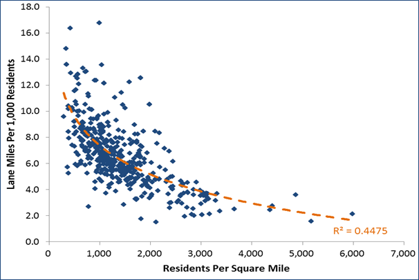
Motor vehicles also require road space. The figure below shows the relationship between per capita lane-miles and density in U.S. urban regions. Each lane-mile per 1,000 residents equals about 64 square feet per capita, so this indicates that roadway supply ranges from less than 120 square feet per capita in dense urban areas to more than 1,000 per capita in sprawled urban areas.
Urban Density Versus Roadway Supply (FHWA 2012, Table HM72)
Walking, bicycling and public transit require far less land and generate far fewer annual vehicle-miles than comparable households living in sprawled areas. The table below calculates the impervious surface area required for three housing types: car-free urban, car-owing urban, and suburban. It assumes that each house has 1,800 square feet of interior space, with three stories in cities (a townhouse or low-rise apartment) and one story in suburbs; the car-free urban household uses a tenth of a vehicle through sharing and taxis, the car-owning urban owns one car, and the suburban household owns two cars; parking spaces (including driveways and access lanes) average 300 sf in cities and 400 sf in suburbs; and road space per vehicle averages 200 sf in cities and 1,000 in suburbs.
Impervious Surface Area Per Household
|
|
Car-Free Urban |
Car-Owning Urban |
Suburban |
|
House – stories |
3 |
3 |
1 |
|
House area (sf) |
600 |
600 |
1,800 |
|
Vehicles per household |
0.1 |
1 |
2 |
|
Parking spaces per vehicle |
2 |
2 |
6 |
|
Area per parking space (sf) |
300 |
300 |
400 |
|
Total parking space area (sf) |
60 |
600 |
2,400 |
|
Road area per vehicle (sf) |
20 |
200 |
2,000 |
|
Total |
680 |
1,400 |
6,200 |
The figure below illustrates the results. A typical two-car suburban household requires an estimated 4,800 square feet more impervious surface than a one-car urban household, and 5,520 more than a car-free urban household.
Impervious Surface Area Per Household
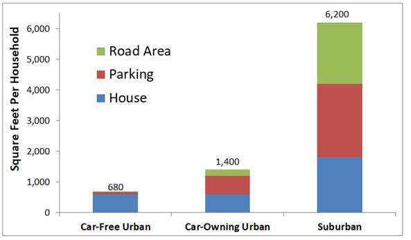
Urban residents require much less impervious surface than if they lived in sprawled, automobile-oriented areas.
Let's put these numbers into perspective. An urban village, where commonly-used services (elementary schools, shops, restaurants, public transit, etc.) are within convenient walking distance of most homes, requires about 15 housing units per acre. The table below compares the impervious surface areas of urban and suburban households.
Urban and Suburban Impervious Surface Areas
|
|
Car-Free Urban |
Car-Owning Urban |
Suburban |
|
Density (household/acre) |
15 |
15 |
4 |
|
Total land per household (sf) |
2,904 |
2,904 |
10,890 |
|
Impervious surface per household (sf) |
680 |
1,400 |
6,200 |
|
Portion of land that is impervious |
23% |
48% |
57% |
|
Remaining green space |
2,240 |
1,504 |
4,690 |
Suburban areas have far more land per household, and so can accommodate the large road and parking areas required by high vehicle ownership rates, and still provide significant green space per household. Urban areas have less land per household and so need to limit vehicle ownership in order to preserve local green space.
It is also interesting to compare impervious surface footprints with urban public park area. According to the Trust for Public Land’s "2017 City Park Facts" [pdf], U.S. cities average 13 park-acres per 1,000 residents, or about 570 sf per capita. This is comparable to per capita housing footprints, but less than the amount of land required for roads and parking in suburban areas.
A healthy forest contains 40-100 significant trees per acre. Since living in a walkable urban neighborhood reduces a household’s impervious surface needs by about 5,000 square feet, or about 1/8 an acre, a typical suburban household displaces 5-12 more trees than the same household living in a walkable urban neighborhood. This indicates that the Bellewood Park project, which displaced ten significant trees to build 83 housing units, protected 415-996 trees that would have been cut for the same number of houses developed at the urban fringe.
Overall, this indicates that sprawled, automobile-oriented development displaces 5-10 times as much green space and generates about three times the emissions as development in walkable urban neighborhoods. Residents seldom consider these impacts. You might remove a few trees around your home to improve your view or reduce falling or fire risks. You probably only notice the land paved for roads and parking when they are congested and you want more. You probably never added up all of the land used by your home, parking and roads, and considered the trees they displace.
Because suburban areas have more land per household, they can accommodate the large amounts of pavement that motor vehicles require and still provide significant green space. Urban areas have less land per household, and so must minimize road and parking area to preserve green space. For example, if urban households own just one vehicle which requires just two 300-square-foot parking spaces and 200 square feet of road space, nearly half of local land area is impervious surface. This does not mean that every household must be car-free, but it does suggest that minimizing vehicle ownership is essential for preserving urban forests and enhancing environmental values.
Enhancing Urban Forests
Many cities are starting to implement pavement-busting [pdf] policies to reduce impervious surface and enhance urban forests:
- Plant more trees.
- Allow more compact housing types (secondary suites, townhouses and apartments).
- Reduce vehicle ownership and travel, and therefore the need for roads and parking facilities.
- Reduce parking requirements and manage parking efficiently so fewer spaces are needed.
- Improve parking facility design, including pervious surfaces, landscaping and shading.
- Narrow roads and road diets.
- Create more urban parks and street boulevards.
- Encourage more natural landscaping, wall and rooftop gardens, planters, and other creative green space.
Conclusions
To create more sustainable communities, consider the forest not just individual trees. It is important to be comprehensive when evaluating development impacts. Debates over infill often focus on highly visible local impacts, such as local vehicle trips and tree losses, but ignore the much larger traffic impacts and habitat losses that would result from more urban fringe development.
Trees are renewable: they grow and eventually die. To improve urban forests, plant more trees than are lost, and do everything possible to reduce the amount of land covered by buildings, roads and parking with policies and projects that support compact development, multimodal transportation, and pavement minimization.
NIMBY arguments often reflect a narrow perspective that ignores impacts elsewhere. Although infill development may and increase local traffic and tree displacement, these impacts are generally much smaller than would result from the same number of homes built in sprawled, automobile-dependent areas where residents own more vehicles and drive more, and so need more pavement for roads and parking. Solid research indicates that households in walkable urban neighborhoods own about half as many vehicles and drive about half as much as they would if located in automobile dependent sprawl; these impacts should be considered in analysis.
Our current development policies cause far more impervious surface area, green space loss and pollution than necessary. No current laws guarantees housing for people, but nearly all municipalities have zoning codes that mandate multiple parking spaces per car, with huge economic and environmental costs. These policies force developers to cut down trees for surface parking, or build expensive underground parking which reduces housing affordability. These policies also subsidize automobile ownership and use. We can do better. If you care about forests you should support more compact infill development, transportation demand management, road diets and parking management.


Analyzing Accessibility Disparities
With better planning we can reduce disparities between drivers and non-drivers in their ability to access services and jobs, improving fairness and economic opportunities for disadvantaged groups.

The Housing Supply Debate: Evaluating the Evidence
Let's rely on science, not ideology and propaganda, when planning solutions to urban unaffordability. Look for credible evidence in the peer-reviewed publications referenced here.
Urban Growth Boundaries Gone Awry: Protection Without Infill
Joe Mathews of Zócalo Public Square views with a great deal of skepticism the urban growth boundaries the voters of Ventura County adjacent to Los Angeles County have enacted since 1995 due to the lack of infill. Another measure is on the ballot.

Trump Administration Could Effectively End Housing Voucher Program
Federal officials are eyeing major cuts to the Section 8 program that helps millions of low-income households pay rent.

Planetizen Federal Action Tracker
A weekly monitor of how Trump’s orders and actions are impacting planners and planning in America.

Ken Jennings Launches Transit Web Series
The Jeopardy champ wants you to ride public transit.

Washington Legislature Passes Rent Increase Cap
A bill that caps rent increases at 7 percent plus inflation is headed to the governor’s desk.

From Planning to Action: How LA County Is Rethinking Climate Resilience
Chief Sustainability Officer Rita Kampalath outlines the County’s shift from planning to implementation in its climate resilience efforts, emphasizing cross-departmental coordination, updated recovery strategies, and the need for flexible funding.

New Mexico Aging Department Commits to Helping Seniors Age ‘In Place’ and ‘Autonomously’ in New Draft Plan
As New Mexico’s population of seniors continues to grow, the state’s aging department is proposing expanded initiatives to help seniors maintain their autonomy while also supporting family caregivers.
Urban Design for Planners 1: Software Tools
This six-course series explores essential urban design concepts using open source software and equips planners with the tools they need to participate fully in the urban design process.
Planning for Universal Design
Learn the tools for implementing Universal Design in planning regulations.
Heyer Gruel & Associates PA
Ada County Highway District
Institute for Housing and Urban Development Studies (IHS)
City of Grandview
Harvard GSD Executive Education
Toledo-Lucas County Plan Commissions
Salt Lake City
NYU Wagner Graduate School of Public Service