


"Neighborhoods at Risk" offers new tools for illustrating the threats posed to communities by climate change.
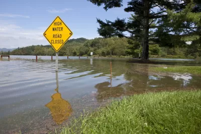
Headwaters Economics has published a new climate planning tool called "neighborhoods at Risk," which offers a simple way to layer information on to maps of neighborhoods and cities for a better understanding the intermixing social, economic, and environmental factors.
According to the website announcing Neighborhoods at Risk:
Neighborhoods at Risk is web-based, free, and designed to meet multiple local planning needs. The data and maps are useful for prioritizing capital improvements and conducting vulnerability assessments, which can be powerful tools that shape land use, policy, and planning decisions. Applications include FEMA Hazard Mitigation Plans and Carbon Disclosure Project (CDP) reporting.
Supplementing the interactive mapping tool are reports on at-risk demographic populations and potential economic outcomes of climate change. The tool is currently active for 18 U.S. cities, with an expansion to all U.S. cities planned for the future.
FULL STORY: Neighborhoods at Risk


A New Resilience Strategy for Toronto
Toronto is preparing for the worst of climate change, but also the stresses of affordability, congestion, and aging infrastructure.

FEMA Resilience Program Cuts Grant Funding
The Building Resilient Infrastructure and Communities program funded projects from flood prevention to power station upgrades.
Report Outlines Strategies for Resilient Wildfire Recovery in LA
Project Recovery offers a roadmap for rebuilding more sustainable and climate-resilient communities after wildfires and other disasters.

Alabama: Trump Terminates Settlements for Black Communities Harmed By Raw Sewage
Trump deemed the landmark civil rights agreement “illegal DEI and environmental justice policy.”

Planetizen Federal Action Tracker
A weekly monitor of how Trump’s orders and actions are impacting planners and planning in America.

The 120 Year Old Tiny Home Villages That Sheltered San Francisco’s Earthquake Refugees
More than a century ago, San Francisco mobilized to house thousands of residents displaced by the 1906 earthquake. Could their strategy offer a model for the present?

In Both Crashes and Crime, Public Transportation is Far Safer than Driving
Contrary to popular assumptions, public transportation has far lower crash and crime rates than automobile travel. For safer communities, improve and encourage transit travel.

Report: Zoning Reforms Should Complement Nashville’s Ambitious Transit Plan
Without reform, restrictive zoning codes will limit the impact of the city’s planned transit expansion and could exclude some of the residents who depend on transit the most.

Judge Orders Release of Frozen IRA, IIJA Funding
The decision is a victory for environmental groups who charged that freezing funds for critical infrastructure and disaster response programs caused “real and irreparable harm” to communities.
Urban Design for Planners 1: Software Tools
This six-course series explores essential urban design concepts using open source software and equips planners with the tools they need to participate fully in the urban design process.
Planning for Universal Design
Learn the tools for implementing Universal Design in planning regulations.
Clanton & Associates, Inc.
Jessamine County Fiscal Court
Institute for Housing and Urban Development Studies (IHS)
City of Grandview
Harvard GSD Executive Education
Toledo-Lucas County Plan Commissions
Salt Lake City
NYU Wagner Graduate School of Public Service