


Paris has made some incredibly ambitious and highly controversial policy changes to improve the city's air quality. In the meantime, there's a new app from Valeo to determine the state of the air quality in the city.
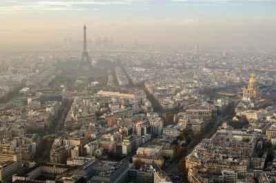
Jake Richardson shares news of a new app by Valeo that provides a real-time air quality map of the city of Paris, and could eventually navigates users around the areas with the worst air quality.
Valeo equipped 19 vehicles, 15 Keolis public transportation vehicles and four G7 Green taxis, with particle sensors. "Valeo’s sensors are designed to collect information on the concentration levels of various pollutants, including fine particles (PM 10 and PM 2.5), carbon monoxide, nitrogen dioxide, sulfur dioxide, and ozone," explains Richardson.
"Once recorded, these data points are fed into an instantaneous air quality index (AQI) map."
Eventually the app developers hope to allow navigation services that allow users to avoid areas in the city with the worst pollution.
FULL STORY: Real-Time Air Pollution Mapping In Paris Created By Valeo — #CleanTechnica Interview


Paris Bike Boom Leads to Steep Drop in Air Pollution
The French city’s air quality has improved dramatically in the past 20 years, coinciding with a growth in cycling.

New Google Map Layer Shows COVID-19 Infection Rates
A new layer showing the seven-day average of confirmed COVID-19 cases started rolling out to Android and iPhones last week.

Analyzing Lynch's City Imageability in the Digital Age
Mahbubur Meenar of Rowan University writes about a recent article he co-authored in the Journal of Planning Education and Research

Alabama: Trump Terminates Settlements for Black Communities Harmed By Raw Sewage
Trump deemed the landmark civil rights agreement “illegal DEI and environmental justice policy.”

Study: Maui’s Plan to Convert Vacation Rentals to Long-Term Housing Could Cause Nearly $1 Billion Economic Loss
The plan would reduce visitor accommodation by 25% resulting in 1,900 jobs lost.

Why Should We Subsidize Public Transportation?
Many public transit agencies face financial stress due to rising costs, declining fare revenue, and declining subsidies. Transit advocates must provide a strong business case for increasing public transit funding.

Paris Bike Boom Leads to Steep Drop in Air Pollution
The French city’s air quality has improved dramatically in the past 20 years, coinciding with a growth in cycling.

Why Housing Costs More to Build in California Than in Texas
Hard costs like labor and materials combined with ‘soft’ costs such as permitting make building in the San Francisco Bay Area almost three times as costly as in Texas cities.

San Diego County Sees a Rise in Urban Coyotes
San Diego County experiences a rise in urban coyotes, as sightings become prevalent throughout its urban neighbourhoods and surrounding areas.
Urban Design for Planners 1: Software Tools
This six-course series explores essential urban design concepts using open source software and equips planners with the tools they need to participate fully in the urban design process.
Planning for Universal Design
Learn the tools for implementing Universal Design in planning regulations.
Smith Gee Studio
Alamo Area Metropolitan Planning Organization
City of Santa Clarita
Institute for Housing and Urban Development Studies (IHS)
City of Grandview
Harvard GSD Executive Education
Toledo-Lucas County Plan Commissions
Salt Lake City
NYU Wagner Graduate School of Public Service