


A report discusses how rising temperatures affect the Twin Cities metropolitan area, and how those effects can be mitigated.

The region faces challenges and opportunities due to climate change, and we can mitigate and reduce extreme heat impacts through thoughtful, collaborative, and proactive planning efforts. The Climate Vulnerability Assessment (CVA) project includes tools and resources for local communities as well as analysis of Metropolitan Council systems and assets, including the following:
- An interactive Localized Flood Screening Map Tool for community use in screening for potential risk of localized flooding from short-term, extreme rain events.
- An interactive Extreme Heat Map Tool for community use in assessing natural or built environment features that affect extreme heat.
- An analysis of Localized Flood Risk vulnerability.
FULL STORY: Keeping Our Cool: Extreme Heat in the Twin Cities Region

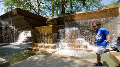
Twin Cities Climate Vulnerability: Extreme Heat
State climatologists are highly confident that heat waves are likely to trend upwards in future summers in Minnesota. To address extreme heat, researchers are identifying the factors that exacerbate extreme heat.

U.S. Communities Increasingly at Risk of Extreme Weather Events
As development pushes into more wildfire-prone areas and climate change makes extreme weather conditions more common, more Americans are experiencing the destructive impacts of climate disasters.

Three Ways Cities Can Combat Extreme Heat
As temperatures rise, there are some relatively simple changes cities can implement to cut cooling costs and deal with spells of extreme heat.

Alabama: Trump Terminates Settlements for Black Communities Harmed By Raw Sewage
Trump deemed the landmark civil rights agreement “illegal DEI and environmental justice policy.”

Study: Maui’s Plan to Convert Vacation Rentals to Long-Term Housing Could Cause Nearly $1 Billion Economic Loss
The plan would reduce visitor accommodation by 25% resulting in 1,900 jobs lost.

Planetizen Federal Action Tracker
A weekly monitor of how Trump’s orders and actions are impacting planners and planning in America.

Restoring Northern India’s Himalayan ‘Water Temples’
Thousands of centuries-old buildings protect the region’s natural springs and serve as community wells and gathering places.

Milwaukee to Double Bike Share Stations
Bublr Bikes, one of the nation’s most successful, will add 500 new e-bikes to its system.

DC Extends Application Window for Outdoor Dining Permits
District restaurants will have until the end of November to apply, but businesses with permits in rush hour parking lanes must end operations on July 31.
Urban Design for Planners 1: Software Tools
This six-course series explores essential urban design concepts using open source software and equips planners with the tools they need to participate fully in the urban design process.
Planning for Universal Design
Learn the tools for implementing Universal Design in planning regulations.
Caltrans
Smith Gee Studio
Institute for Housing and Urban Development Studies (IHS)
City of Grandview
Harvard GSD Executive Education
Toledo-Lucas County Plan Commissions
Salt Lake City
NYU Wagner Graduate School of Public Service