


New research reveals that some coastal areas are sinking by as much as 5 millimeters per year, which could threaten key infrastructure.
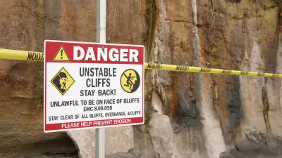
A new study highlights the urgency of restructuring East Coast infrastructure, showing that cities on the Atlantic are sinking by as much as 5 millimeters per year. “Global warming is causing a rise in sea levels, meaning coastal areas are particularly at risk,” explains Robyn White in Newsweek.
While entire areas are unlikely to sink into the ocean, sea level rise threatens infrastructure near the coast. “For example, significant areas of critical infrastructure in New York, including JFK and LaGuardia airports and its runways, along with the railway systems, are affected by subsidence rates exceeding 2 mm per year,” explains Leonard Ohenhen, lead author of the study.
Sea level rise and subsidence is already impacting U.S. infrastructure. On the West Coast, a key Southern California rail corridor was shut down on and off for months as a result of coastal erosion. In Northern California, the California Department of Transportation (Caltrans) completed its first-ever road relocation project in November of last year.
FULL STORY: US Cities Sinking on the East Coast, Threatening Critical Infrastructure


State Leaders Warn of Risks to Southern California Rail Corridor
Coastal erosion and rising sea levels threaten one of the nation’s most scenic—and strategically important—rail corridors.

California Completes First Coastal Erosion Mitigation Project
Caltrans moved a segment of the state’s celebrated Highway 1 inland by 400 feet to avoid erosion caused by sea level rise.
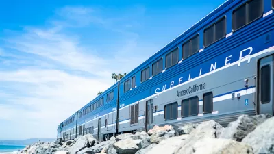
Sea Level Rise Threatens an Iconic California Train
A scenic Southern California line could require relocation as rising sea levels destabilize the coastal soil that supports its tracks.

Trump Administration Could Effectively End Housing Voucher Program
Federal officials are eyeing major cuts to the Section 8 program that helps millions of low-income households pay rent.

Planetizen Federal Action Tracker
A weekly monitor of how Trump’s orders and actions are impacting planners and planning in America.

Ken Jennings Launches Transit Web Series
The Jeopardy champ wants you to ride public transit.

Rebuilding Smarter: How LA County Is Guiding Fire-Ravaged Communities Toward Resilience
Los Angeles County is leading a coordinated effort to help fire-impacted communities rebuild with resilience by providing recovery resources, promoting fire-wise design, and aligning reconstruction with broader sustainability and climate goals.

When Borders Blur: Regional Collaboration in Action
As regional challenges outgrow city boundaries, “When Borders Blur” explores how cross-jurisdictional collaboration can drive smarter, more resilient urban planning, sharing real-world lessons from thriving partnerships across North America.

Philadelphia Is Expanding its Network of Roundabouts
Roundabouts are widely shown to decrease traffic speed, reduce congestion, and improve efficiency.
Urban Design for Planners 1: Software Tools
This six-course series explores essential urban design concepts using open source software and equips planners with the tools they need to participate fully in the urban design process.
Planning for Universal Design
Learn the tools for implementing Universal Design in planning regulations.
Ada County Highway District
Clanton & Associates, Inc.
Jessamine County Fiscal Court
Institute for Housing and Urban Development Studies (IHS)
City of Grandview
Harvard GSD Executive Education
Toledo-Lucas County Plan Commissions
Salt Lake City
NYU Wagner Graduate School of Public Service