


New park spaces to meet the needs of underserved communities are being planned along the Los Angeles River.
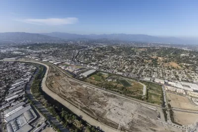
The "100-Acre Partnership at Taylor Yard" has been formed to coordinate and collaborate in planning the largest, continuous open space along the Los Angeles River. Specifically, this partnership involves the city of Los Angeles, California State Parks, the Mountains Recreation and Conservation Authority (MRCA), and the public.
Three properties are included in the 100-acre unified open space:
- The Rio de Los Angeles State Park, an existing 40-acre park owned by State Parks and managed cooperatively by State Parks and the city of Los Angeles through its Department of Recreation and Parks;
- The Taylor Yard G1 Bowtie parcel, an 18-acre property known for its distinctive boundary shape, which is owned and managed and in the process of design by State Parks; and
- The Taylor Yard G2 parcel, a 42-acre property that is owned by the city. The MRCA purchased and now holds the rights to develop a 12.5-acre easement within the Taylor Yard G2 parcel owned by the City.
The partnership’s first project will be an early activation river edge access project, currently called Paseo del Río. The project will stretch along both the G2 and Bowtie Parcels at Taylor Yard along the L.A. River over approximately 8 acres (about six acres on G2, and two acres on Bowtie). Together, the project will provide over one mile of contiguous riverfront public access.
For more information, please read the source article by Robert Fulton and visit the 100 Acre Partnership website.
FULL STORY: Reclaiming Taylor Yard: Reshaping 100 acres of railroad property into post-industrial parkland

Fundraising Begins for Development of 100-Acre Park in Los Angeles
River LA has launched a capital campaign to develop the 100-acre Taylor Yard Park, featuring amenities like a welcome pavilion, wetlands, and a pedestrian bridge, with completion costs estimated at over $1 billion.
Los Angeles County Invests in Wildfire Recovery for Parks, Trails, and Open Space
The $4.25 million RESTORE Program supports the recovery of parks, trails, and open spaces damaged by the January 2025 wildfires through targeted grants that promote community healing, wildfire resilience, and equitable access to nature.

Healing Through Parks: Altadena’s Path to Recovery After the Eaton Fire
In the wake of the Eaton Fire, Altadena is uniting to restore Loma Alta Park, creating a renewed space for recreation, community gathering, and resilience.

Alabama: Trump Terminates Settlements for Black Communities Harmed By Raw Sewage
Trump deemed the landmark civil rights agreement “illegal DEI and environmental justice policy.”

Planetizen Federal Action Tracker
A weekly monitor of how Trump’s orders and actions are impacting planners and planning in America.

The 120 Year Old Tiny Home Villages That Sheltered San Francisco’s Earthquake Refugees
More than a century ago, San Francisco mobilized to house thousands of residents displaced by the 1906 earthquake. Could their strategy offer a model for the present?

Ken Jennings Launches Transit Web Series
The Jeopardy champ wants you to ride public transit.

BLM To Rescind Public Lands Rule
The change will downgrade conservation, once again putting federal land at risk for mining and other extractive uses.

Indy Neighborhood Group Builds Temporary Multi-Use Path
Community members, aided in part by funding from the city, repurposed a vehicle lane to create a protected bike and pedestrian path for the summer season.
Urban Design for Planners 1: Software Tools
This six-course series explores essential urban design concepts using open source software and equips planners with the tools they need to participate fully in the urban design process.
Planning for Universal Design
Learn the tools for implementing Universal Design in planning regulations.
Clanton & Associates, Inc.
Jessamine County Fiscal Court
Institute for Housing and Urban Development Studies (IHS)
City of Grandview
Harvard GSD Executive Education
Toledo-Lucas County Plan Commissions
Salt Lake City
NYU Wagner Graduate School of Public Service