


Data is the key to crafting Vision Zero plans with community buy-in.
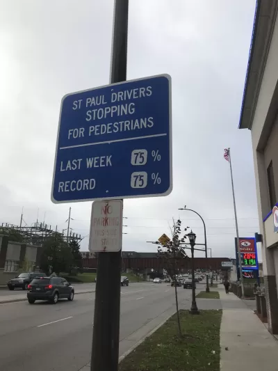
We’ve all read the alarming headlines: Driving kills more people in the U.S. than handguns. We’ve also likely witnessed cars weaving in and out of traffic, speeding by us like we’re standing still.
Even more distressing are the statistics. Preliminary data compiled by the National Safety Council show that 42,000 people died in motor vehicle crashes in the U.S. in 2020, an increase of 24% over the previous year. Pedestrian fatality rates, meanwhile, jumped 21% — the highest increase since 1975 – despite the fact that vehicle miles traveled dropped 13% due to the pandemic. According to the National Highway Traffic Safety Administration, a pedestrian is killed every two hours and injured every seven minutes somewhere in the U.S.
To counter this untenable state of affairs, an increasing number of communities nationwide are turning to a Vision Zero strategy, one that aims to eliminate all traffic fatalities and severe injuries while increasing safe, healthy, equitable mobility for all.
While many of the tactics that comprise Vision Zero are well known – from decreasing the legal speed limit to installing traffic calming measures (speed bumps, roundabouts, etc.) to improving roadway lighting and pedestrian crossings – the technological advances and data-driven analytics at the heart of those tactics’ effectiveness are often overlooked.
FULL STORY: Data-Driven Analytics Are at the Heart of Vision Zero Goals

Milwaukee Announces 60 Traffic Calming Projects for 2025
The city has successfully reduced traffic deaths and aims to eliminate them completely within the next decade.
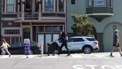
San Francisco Slow Streets Bucks Citywide Trend, Reducing Injuries by 61 Percent
Low-cost interventions aimed at slowing traffic are making a major impact on road safety.
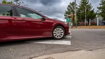
Banning Right Turns on Red Just One Step Toward Vision Zero
Experts caution that blanket bans on right turns on red make only a slight contribution to reducing fatal crashes, and other interventions are needed to bring down traffic fatalities.

Alabama: Trump Terminates Settlements for Black Communities Harmed By Raw Sewage
Trump deemed the landmark civil rights agreement “illegal DEI and environmental justice policy.”

Planetizen Federal Action Tracker
A weekly monitor of how Trump’s orders and actions are impacting planners and planning in America.

How Atlanta Built 7,000 Housing Units in 3 Years
The city’s comprehensive, neighborhood-focused housing strategy focuses on identifying properties and land that can be repurposed for housing and encouraging development in underserved neighborhoods.

In Both Crashes and Crime, Public Transportation is Far Safer than Driving
Contrary to popular assumptions, public transportation has far lower crash and crime rates than automobile travel. For safer communities, improve and encourage transit travel.

Report: Zoning Reforms Should Complement Nashville’s Ambitious Transit Plan
Without reform, restrictive zoning codes will limit the impact of the city’s planned transit expansion and could exclude some of the residents who depend on transit the most.

Judge Orders Release of Frozen IRA, IIJA Funding
The decision is a victory for environmental groups who charged that freezing funds for critical infrastructure and disaster response programs caused “real and irreparable harm” to communities.
Urban Design for Planners 1: Software Tools
This six-course series explores essential urban design concepts using open source software and equips planners with the tools they need to participate fully in the urban design process.
Planning for Universal Design
Learn the tools for implementing Universal Design in planning regulations.
Jessamine County Fiscal Court
Caltrans
Institute for Housing and Urban Development Studies (IHS)
City of Grandview
Harvard GSD Executive Education
Toledo-Lucas County Plan Commissions
Salt Lake City
NYU Wagner Graduate School of Public Service