


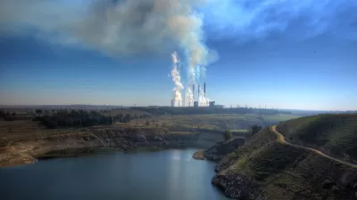
An investigation by ProPublica has produced something the U.S. Environmental Protection Agency has never been able to complete: a nationwide map of the cancer risks created by industrial sources of air pollution.

Al Shaw and Lylla Younes reveal the findings of a new ProPublica analysis into the toxic air pollution emitted into communities around the country.
Here's how Shaw and Younes summarize the investigation and the findings:
ProPublica’s analysis of five years of modeled EPA data identified more than 1,000 toxic hot spots across the country and found that an estimated 250,000 people living in them may be exposed to levels of excess cancer risk that the EPA deems unacceptable.
According to the article, the U.S. Environmental Protection Agency collects data from facilities known to emit large amounts of toxic air pollution, but the agency has never released thus data.
To finally publishing this data for public consumption, the source article (also linked below) maps cancer risk from industrial pollution.
The big, interactive coverage of the investigation also includes a separate article, credited to Younes and Shaw in addition to Lisa Song and Maya Miller. Here's how that article summarizes the stakes of the data revealed by the investigation:
From the urban sprawl of Houston to the riverways of Virginia, air pollution from industrial plants is elevating the cancer risk of an estimated quarter of a million Americans to a level the federal government considers unacceptable.
FULL STORY: The Most Detailed Map of Cancer-Causing Industrial Air Pollution in the U.S.

The Trump Administration's Environmental Policies Have Consequences for Black Lives
A Trump administration decision not to tighten Clean Air Act restrictions on soot pollution will have more consequences for Black Americans.

EPA Relaxes Environmental Rules, Cites Coronavirus
During the outbreak, the agency will allow companies to monitor themselves for pollution violations.

U.S. Air Quality Declining, Taking Lives
Particulate matter air pollution has been on the rise since 2017, according to new research. Wildfires, economic activity, and lax regulation are potentially to blame.

Study: Maui’s Plan to Convert Vacation Rentals to Long-Term Housing Could Cause Nearly $1 Billion Economic Loss
The plan would reduce visitor accommodation by 25,% resulting in 1,900 jobs lost.

North Texas Transit Leaders Tout Benefits of TOD for Growing Region
At a summit focused on transit-oriented development, policymakers discussed how North Texas’ expanded light rail system can serve as a tool for economic growth.

Why Should We Subsidize Public Transportation?
Many public transit agencies face financial stress due to rising costs, declining fare revenue, and declining subsidies. Transit advocates must provide a strong business case for increasing public transit funding.

How to Make US Trains Faster
Changes to boarding platforms and a switch to electric trains could improve U.S. passenger rail service without the added cost of high-speed rail.

Columbia’s Revitalized ‘Loop’ Is a Hub for Local Entrepreneurs
A focus on small businesses is helping a commercial corridor in Columbia, Missouri thrive.

Invasive Insect Threatens Minnesota’s Ash Forests
The Emerald Ash Borer is a rapidly spreading invasive pest threatening Minnesota’s ash trees, and homeowners are encouraged to plant diverse replacement species, avoid moving ash firewood, and monitor for signs of infestation.
Urban Design for Planners 1: Software Tools
This six-course series explores essential urban design concepts using open source software and equips planners with the tools they need to participate fully in the urban design process.
Planning for Universal Design
Learn the tools for implementing Universal Design in planning regulations.
City of Santa Clarita
Ascent Environmental
Institute for Housing and Urban Development Studies (IHS)
City of Grandview
Harvard GSD Executive Education
Toledo-Lucas County Plan Commissions
Salt Lake City
NYU Wagner Graduate School of Public Service