


The city of Paradise is employing a natural hazard mitigation strategy long practiced in flood zones. The idea could be expanded in other places where wildland meets human development.
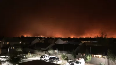
As wildfires once again rage across the Western United States, NPR's Morning Edition recently returned to Paradise, California, where the 2018 Camp Fire raced through the town, killing 85 people and destroying about 19,000 structures.
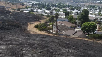
To prevent the same tragedy again, Paradise is identifying and buying high risk properties in the Camp Fire burn area. Where willing sellers are found on high risk properties, the city buys the property and transforms the land into fire resistant green spaces.
"The idea is to connect the burnt out lots to the town's existing park land," according to the article. "That's good for adding more recreation but it could also work as a fuel break."
This is not a program relying on eminent domain. So far, the city has "acquired about 300 acres of new land, with about 500 more acres in the pipeline, mostly paid for with non profit grant money and donations."
Dan Efseaff, director of the Paradise Recreation and District, is quoted extensively in the article, including a statement that the city needs $20 million more to have a serious impact on the risk of wildfire.
As noted in the article, the government has been buying back properties in flood areas for decades. "And as the West cooks in extreme drought, there's interest in replicating this in certain high risk fire zones. A change in federal law recently devoted funding to study the feasibility of this in places like the Sierra Nevada, and Paradise is eager for federal support."
For more details of how these private properties can be transformed into fire resistant park space, read an article written recently by Jonah Susskind for the American Society of Landscape Architect's blog. Susskind describes this kind of fire resistant park space as Wildfire Risk Reduction Buffers (WRRBs).
The basic concept ensures that combustible materials and flammable vegetation is cleared from the area immediately around structures, and that certain vegetation management guidelines are followed further out (typically in designated zones between 5 and 100 feet). Essentially, the WRRB idea takes this approach and scales it up to the size of the whole community by ensuring that lower-risk land uses are maintained between developed areas and undeveloped wildlands.
The article also describes an effort by SWA Group to take the concept even further by "using these greenbelts as a spatial framework for reintroducing prescribed fire into the landscape in order to reduce regional fuel loads while simultaneously enhancing the ecological health of densely forested areas."
FULL STORY: In Fire Scorched California, Town Aims To Buy The Highest At-Risk Properties

In Paradise, Using Greenbelts to Manage Wildfires
The Camp Fire in California devasted the town of Paradise. As rebuilding progresses, local leaders are looking to protect the town using nature-based fire resilience strategies.
Resilient Communities, Healthy Ecosystems: A Balanced Approach to Wildfires
Effective wildfire mitigation in California requires a holistic approach that goes beyond large-scale vegetation removal, emphasizing home hardening, defensible space, strategic planning, and reducing human-caused ignitions.
Fire-Ravaged Paradise Plans for a Resilient Rebirth
A new urban design plan calls for a robust buffer zone to protect the town from fast-spreading fires, among other mitigation measures.

Alabama: Trump Terminates Settlements for Black Communities Harmed By Raw Sewage
Trump deemed the landmark civil rights agreement “illegal DEI and environmental justice policy.”

Planetizen Federal Action Tracker
A weekly monitor of how Trump’s orders and actions are impacting planners and planning in America.

The 120 Year Old Tiny Home Villages That Sheltered San Francisco’s Earthquake Refugees
More than a century ago, San Francisco mobilized to house thousands of residents displaced by the 1906 earthquake. Could their strategy offer a model for the present?

In Both Crashes and Crime, Public Transportation is Far Safer than Driving
Contrary to popular assumptions, public transportation has far lower crash and crime rates than automobile travel. For safer communities, improve and encourage transit travel.

Report: Zoning Reforms Should Complement Nashville’s Ambitious Transit Plan
Without reform, restrictive zoning codes will limit the impact of the city’s planned transit expansion and could exclude some of the residents who depend on transit the most.

Judge Orders Release of Frozen IRA, IIJA Funding
The decision is a victory for environmental groups who charged that freezing funds for critical infrastructure and disaster response programs caused “real and irreparable harm” to communities.
Urban Design for Planners 1: Software Tools
This six-course series explores essential urban design concepts using open source software and equips planners with the tools they need to participate fully in the urban design process.
Planning for Universal Design
Learn the tools for implementing Universal Design in planning regulations.
Clanton & Associates, Inc.
Jessamine County Fiscal Court
Institute for Housing and Urban Development Studies (IHS)
City of Grandview
Harvard GSD Executive Education
Toledo-Lucas County Plan Commissions
Salt Lake City
NYU Wagner Graduate School of Public Service