


A new study drives home the need for heat reduction measures in areas populated by lower-income residents.
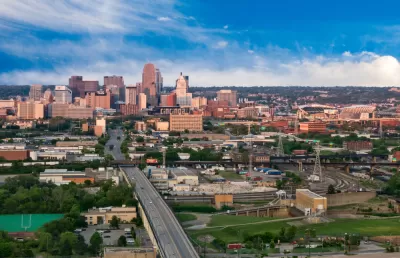
A heat map produced by measuring temperatures across Cincinnati on August 10, 2020 bears a striking resemblance to maps of household income, neighborhood demographics, and the history of redlining, reports Danny Wicentowski. The findings of the study support the unfortunate reality that communities of color in the United States bear the brunt of climate change impacts.
The report, made possible by funding from the National Oceanic and Atmospheric Administration's Climate Program Office, "observed that large developments absorb and retain heat throughout the day, affecting even nearby residences," Wicentowski writes. The report further noted a commonality between the hottest areas: a notable lack of vegetation. Conversely, the coolest temperatures measured on that summer day were recorded in areas with ample tree-cover.
Wicentowski reminds readers that minimal tree canopy in lower-income areas is hardly a revelation and has even been noted in a 2018 version of the Green Cincinnati Plan. One of the plan's "major resiliency recommendations: increase the city’s tree canopy to shield communities from ever-increasing heat in the summer and to soak up water from those massive rainfall events."
According to a Cincinnati Parks press release, the data from the study will be used to prioritize areas of service to "implement targeted planting plans in communities with the greatest need."


Research Shows Urban Trees Stave off Depression
A new study shows that regular exposure to trees and green spaces has a powerful impact on depression and mental health.

Cincinnati Seeks to Repurpose Its Unused Subway Tunnel
City officials are looking for proposals to use Cincinnati's long-abandoned subway tunnels, but not for transit; they already tried that.

Planting for the Future: The Urban Trees of Tomorrow
How urban forest managers are preparing urban tree canopies for tomorrow’s climates.

Trump Administration Could Effectively End Housing Voucher Program
Federal officials are eyeing major cuts to the Section 8 program that helps millions of low-income households pay rent.

Planetizen Federal Action Tracker
A weekly monitor of how Trump’s orders and actions are impacting planners and planning in America.

Ken Jennings Launches Transit Web Series
The Jeopardy champ wants you to ride public transit.

NYC Open Streets Organizers Call for City Support
The number of open streets projects has dropped year after year as volunteer groups struggle to fund and staff them.

Crime Continues to Drop on Philly, San Francisco Transit Systems
SEPTA and BART both saw significant declines in violent crime in the first quarter of 2025.

How South LA Green Spaces Power Community Health and Hope
Green spaces like South L.A. Wetlands Park are helping South Los Angeles residents promote healthy lifestyles, build community, and advocate for improvements that reflect local needs in historically underserved neighborhoods.
Urban Design for Planners 1: Software Tools
This six-course series explores essential urban design concepts using open source software and equips planners with the tools they need to participate fully in the urban design process.
Planning for Universal Design
Learn the tools for implementing Universal Design in planning regulations.
Heyer Gruel & Associates PA
Ada County Highway District
Institute for Housing and Urban Development Studies (IHS)
City of Grandview
Harvard GSD Executive Education
Toledo-Lucas County Plan Commissions
Salt Lake City
NYU Wagner Graduate School of Public Service