


A $26.2 billion proposal to protect the coastal area around Galveston has evolved since its first iteration in 2018.
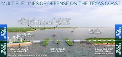
"The Army Corps of Engineers has released the second draft of proposed coastal barrier that would fundamentally alter the southeast Texas coastline, with massive sea gates across the Houston Ship Channel and 43 miles of dunes and renourished beaches spanning Bolivar Peninsula and Galveston," reports Nick Powell.
The Army Corps of Engineers selected a final version of the plan from four alternatives almost exactly two years ago. The project is designed to protect the coast of Texas in and around Galveston from a storm surge like the one that hit the area during Hurricane Ike in 2008. Among the big components of the project is a gate across the mouth of Galveston Bay and the Houston Ship Channel, according to Powell. "The gate would remain open year-round and would only be closed when a storm-surge event threatens the Texas coast or for annual maintenance checks and inspections," explains Powell. A ring levee protecting the north side of Galveston Island would also be connected to the Galveston Seawall.
The project, formerly referred to as the "Ike Dike," has undergone significant changes since its previous version: The gate would restrict tidal flow from the bay to the Gulf of Mexico by 10 percent rather than the originally proposed 27 percent. The price has also been lowered from an estimated $32 billion to the new cost of $26.2 billion, reports Powell. Since October 2018, the plan has also overcome some of the local opposition, on environmental grounds, to the plan after a series of hurricanes passed near the area this year alone and as the plan has been revised.
Now the plan will begin a public engagement process that will last until December 14. To help present the plan to the public, the Army Corps of Engineers has released interactive web features including 3-D virtual tours.
FULL STORY: Revised ‘Ike Dike’ plan would cost $26.2B, include massive sea gates and 43 miles of sand dunes


$31 Billion Hurricane Protection Plan Proposed for Texas
The U.S. Army Corps of Engineers has proposed a suite of coastal infrastructure projects—i.e., floodgates and seawalls—to shore up the coast of Texas against Hurricane- and sea level rise-aided water.
$31 Billion ‘Ike Dike’ Hurricane Protection Project Moving Through Congress
Congress authorized the $31 billion ‘Ike Dike’ sea-level rise adaptation project, along with a laundry list of other water infrastructure projects.
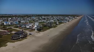
Looking for a Beach House? Check Your Risk First.
A new report from the insurance industry names the historic town of Galveston, Texas as the riskiest place to buy a beach house in the United States.

Trump Administration Could Effectively End Housing Voucher Program
Federal officials are eyeing major cuts to the Section 8 program that helps millions of low-income households pay rent.

Planetizen Federal Action Tracker
A weekly monitor of how Trump’s orders and actions are impacting planners and planning in America.

Ken Jennings Launches Transit Web Series
The Jeopardy champ wants you to ride public transit.

Rebuilding Smarter: How LA County Is Guiding Fire-Ravaged Communities Toward Resilience
Los Angeles County is leading a coordinated effort to help fire-impacted communities rebuild with resilience by providing recovery resources, promoting fire-wise design, and aligning reconstruction with broader sustainability and climate goals.

When Borders Blur: Regional Collaboration in Action
As regional challenges outgrow city boundaries, “When Borders Blur” explores how cross-jurisdictional collaboration can drive smarter, more resilient urban planning, sharing real-world lessons from thriving partnerships across North America.

Philadelphia Is Expanding its Network of Roundabouts
Roundabouts are widely shown to decrease traffic speed, reduce congestion, and improve efficiency.
Urban Design for Planners 1: Software Tools
This six-course series explores essential urban design concepts using open source software and equips planners with the tools they need to participate fully in the urban design process.
Planning for Universal Design
Learn the tools for implementing Universal Design in planning regulations.
Ada County Highway District
Clanton & Associates, Inc.
Jessamine County Fiscal Court
Institute for Housing and Urban Development Studies (IHS)
City of Grandview
Harvard GSD Executive Education
Toledo-Lucas County Plan Commissions
Salt Lake City
NYU Wagner Graduate School of Public Service