


Induced traffic occurs when new highway capacity speeds up traffic, allowing travelers to drive further, increasing sprawl. A review of major highway project plans finds that most fail to accurately account for induced travel effects.
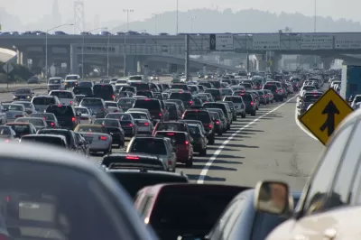
The problem of induced traffic, aka induced demand, is well-documented in the literature. Yet it is too rarely accounted for in practice. A new paper by Jamey M.B. Volker (University of California-Davis) and co-authors examines the environmental documents from five major highway projects to see how they addressed induced traffic. The results: not well.
Induced traffic occurs when new highway capacity speeds up traffic, allowing travelers to drive further and land uses to spread out. These rebound effects eventually reduce travel speeds again, leaving travelers with longer trips in congested conditions. Failing to account for induced traffic makes highway capacity projects look much more beneficial than they really are.
Unfortunately, the environmental documents from the five projects reviewed in the paper generally ignored induced traffic except when prompted by public comment. Even then, discussion of the problem was sometimes internally inconsistent and failed to reflect findings from the literature. In three of the five cases, environmental documents did make an estimate of induced traffic, but these estimates were much less than the literature would suggest—and in two cases by orders of magnitude.
The paper points to reliance on demand models as an important source of bias in induced traffic estimates:
Current travel demand models do not fully account for induced vehicle travel, as detailed by Milam et al. (6) and Litman (15). The issue is that most models do not include all of the feedback loops necessary to represent the secondary effects of capacity expansion. These models were designed to estimate the effect of capacity expansion on travel times for a given population and employment level for the region. Many models now feed the estimated travel times back into the mode split stage of the model, thereby accounting for potential shifts away from transit and active modes resulting from improved travel times. Few models feed the estimated travel times back into the trip distribution or trip generation stages of the model, thereby ignoring the possibility that improved travel times will increase the number of trips that residents choose to make or the possibility that they will choose more distant destinations for their trips. Few models feed estimated travel times back into assumptions about the distribution and growth of population and employment that also influence the frequency and length of trips. In short, the models may do an adequate job of accounting for changes in route and shifts in mode, but they underestimate increases in VMT attributable to increases in trip frequencies and lengths that the capacity expansion will induce.
Induced traffic estimates can be improved by using lane-miles-to-VMT elasticities, such as those in the Induced Travel Calculator at UC-Davis, the paper suggests. The calculator’s estimates are based on areawide averages and may miss facility-specific conditions, but they can be used as default estimates or in combinations with other methodologies. The calculator is currently populated only with data from urbanized counties in California. But other states could readily develop their own calculators using available data.
FULL STORY: Induced Vehicle Travel in the Environmental Review Process


Planning for Congestion Relief
The third and final installment of Planetizen's examination of the role of the planning profession in both perpetuating and solving traffic congestion.

How Planning Fails to Solve Congestion
Solutions for congestion are never as simple and easy as armchair planners and engineers would like you to believe—especially those who suggest that congestion can be solved by forever building more roadway capacity.

Planning and the Complicated Causes and Effects of Congestion
What do planners know about congestion, and what can they do about it? Explanations and solutions are less obvious than they seem (part one of a three-part series).

Alabama: Trump Terminates Settlements for Black Communities Harmed By Raw Sewage
Trump deemed the landmark civil rights agreement “illegal DEI and environmental justice policy.”

Planetizen Federal Action Tracker
A weekly monitor of how Trump’s orders and actions are impacting planners and planning in America.

The 120 Year Old Tiny Home Villages That Sheltered San Francisco’s Earthquake Refugees
More than a century ago, San Francisco mobilized to house thousands of residents displaced by the 1906 earthquake. Could their strategy offer a model for the present?

Ken Jennings Launches Transit Web Series
The Jeopardy champ wants you to ride public transit.

BLM To Rescind Public Lands Rule
The change will downgrade conservation, once again putting federal land at risk for mining and other extractive uses.

Indy Neighborhood Group Builds Temporary Multi-Use Path
Community members, aided in part by funding from the city, repurposed a vehicle lane to create a protected bike and pedestrian path for the summer season.
Urban Design for Planners 1: Software Tools
This six-course series explores essential urban design concepts using open source software and equips planners with the tools they need to participate fully in the urban design process.
Planning for Universal Design
Learn the tools for implementing Universal Design in planning regulations.
Clanton & Associates, Inc.
Jessamine County Fiscal Court
Institute for Housing and Urban Development Studies (IHS)
City of Grandview
Harvard GSD Executive Education
Toledo-Lucas County Plan Commissions
Salt Lake City
NYU Wagner Graduate School of Public Service