


Black Americans have moved on from formerly redlined neighborhoods, and other minorities and whites have moved in. The wave of presidential campaigns that have based housing policy proposals on redlining maps might be misguided as a result.
Andre M. Perry and David Harshbarger share the findings of new research suggesting that by focusing on redlining maps, housing policy reforms might not deliver benefits to the intended population.
The context for the research is set by the presidential campaign platforms of several Democratic hopefuls for the job:
Over the last few months, several Democratic presidential hopefuls—namely Sen. Kamala Harris (Calif.), Sen. Elizabeth Warren (Mass.), and South Bend, Ind. Mayor Pete Buttigieg—have released housing proposals that utilize a curious vector to implement their respective remedies for historical discrimination: redlining maps.
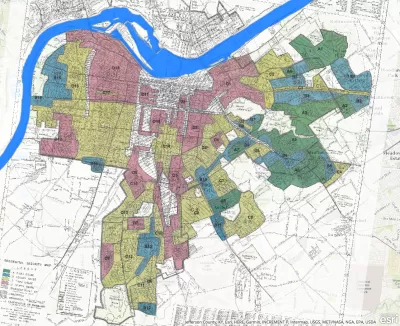
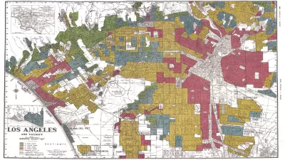
Redlining was the practice of outlining areas with sizable Black populations in red ink on maps as a warning to mortgage lenders, effectively isolating Black people in areas that would suffer lower levels of investment than their white counterparts. The Democratic candidates hope that the contours of these old maps—once used by the government-sponsored Home Owners’ Loan Corporation (HOLC) from 1933 to 1977—offer the blueprint for closing the racial homeownership gap and increasing prosperity among largely Black and Brown Americans who were robbed of wealth for generations under redlining’s legal discriminatory policy.
So what's the problem with the idea of focusing relief in the places where the most damage was done by racist and discriminatory regulatory history? In 2019, Black populations do not make up most of the residents in formerly redlined neighborhoods.
The University of Richmond’s Mapping Inequality project has digitized scans of the HOLC redlining maps held in the National Archives. Examination of the maps, numbering over 200, reveals that approximately 11 million Americans (10,852,727) live in once-redlined areas, according to the latest population data from the Census Bureau’s American Community Survey (2017). This population is majority-minority but not majority-Black, and, contrary to conventional perceptions, Black residents also do not form a plurality in these areas overall. The Black population share is approximately 28%, ranking third among the racial groups who live in formerly redlined areas, behind white and Latino or Hispanic residents.
The article shares a lot more data and insights about the variations between formerly redline neighborhoods, the changes in demographics in those areas, and more reasons to question the HOLC's redlining maps as a useful proxy for black neighborhoods when setting progressive housing policy.
FULL STORY: America’s formerly redlined neighborhoods have changed, and so must solutions to rectify them

New Mapping Tool Illuminates the Consequences of Redlining
According to Next City, a new mapping tool from the National Community Reinvestment Coalition reveals the roots of gentrification in addition to making stark a history of discrimination.

Formerly Redlined Neighborhoods Continue to Suffer Disparate Air Pollution
How did ZIP codes become such powerful determinants of public health? New new evidence of the disparate air pollution of redlined neighborhoods partly answers that question.
Housing Discrimination Still a Vast Problem, Survey Finds
In a survey conducted last October, Zillow found that 27 percent of respondents believe they've experienced housing discrimination. National Fair Housing Alliance president Lisa Rice discusses why that is.

Alabama: Trump Terminates Settlements for Black Communities Harmed By Raw Sewage
Trump deemed the landmark civil rights agreement “illegal DEI and environmental justice policy.”

Study: Maui’s Plan to Convert Vacation Rentals to Long-Term Housing Could Cause Nearly $1 Billion Economic Loss
The plan would reduce visitor accommodation by 25% resulting in 1,900 jobs lost.

Planetizen Federal Action Tracker
A weekly monitor of how Trump’s orders and actions are impacting planners and planning in America.

Federal Homelessness Agency Places Entire Staff on Leave
The U.S. Interagency Council on Homelessness is the only federal agency dedicated to preventing and ending homelessness.

Restoring Northern India’s Himalayan ‘Water Temples’
Thousands of centuries-old buildings protect the region’s natural springs and serve as community wells and gathering places.

Milwaukee to Double Bike Share Stations
Bublr Bikes, one of the nation’s most successful, will add 500 new e-bikes to its system.
Urban Design for Planners 1: Software Tools
This six-course series explores essential urban design concepts using open source software and equips planners with the tools they need to participate fully in the urban design process.
Planning for Universal Design
Learn the tools for implementing Universal Design in planning regulations.
Caltrans
Smith Gee Studio
Institute for Housing and Urban Development Studies (IHS)
City of Grandview
Harvard GSD Executive Education
Toledo-Lucas County Plan Commissions
Salt Lake City
NYU Wagner Graduate School of Public Service