


How did ZIP codes become such powerful determinants of public health? New new evidence of the disparate air pollution of redlined neighborhoods partly answers that question.
A study published today by the Environmental Science and Technology Letters connects the racial disparities of air pollution of contemporary U.S. cities to the redlining practices originating in the New Deal of the 1930s. The new research adds to a body of work revealing the environmental justice legacy of redlining—previous studies documented the persistence of urban heat islands, lack of tree canopy, and lack of green space in formerly redlined neighborhoods.
The study, written by researchers at the University of California, Berkeley and the University of Washington, studied intraurban air pollution disparities in 202 U.S. cities, comparing Home Owners’ Loan Corporation (HOLC) maps of investment risk grades (i.e., redlining maps) to 2010 estimates of NO2 and PM2.5 air pollution levels, and demographic information from the 2010 U.S. census. The researchers find clear evidence that the legacy of redlining is written on the lungs of the communities of color still living in formerly redlined neighborhoods. Moreover, while communities of color are subject to higher levels of pollution at every income level, intraurban disparities for NO2 and PM2.5 are substantially larger by historical HOLC grade than they are by race and ethnicity, according to the study.
The study attracted attention from two of the nation's largest daily newspapers—the New York Times and the Washington Post—both of which published articles about the study at exactly 8 am ET this morning.
Writing for the Washington Post, Darryl Fears begins by adding depressed home values, lower economic mobility, and high levels of poverty to the list of contemporary consequences of redlining, in addition to the air pollution, excessive heat, and lack of tree canopy and park space mentioned above.
"The practice known as redlining was outlawed more than a half-century ago, but it continues to impact people who live in neighborhoods that government mortgage officers shunned for 30 years because people of color and immigrants lived in them," writes Fears to introduce the concept of redlining to the uninitiated.
The analysis, published in the journal Environmental Science and Technology Letters, found that, compared with White people, Black and Latino Americans live with more smog and fine particulate matter from cars, trucks, buses, coal plants and other nearby industrial sources in areas that were redlined. Those pollutants inflame human airways, reduce lung function, trigger asthma attacks and can damage the heart and cause strokes.
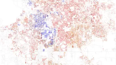
The coverage from the Washington Post includes useful infographics.
Writing for the New York Times, Raymond Zhong and Nadja Popovich helpfully document the demographic legacy of redlining underlying the news about air pollution disparities: "To this day, historically redlined neighborhoods are more likely to have high populations of Black, Latino and Asian residents than areas that were favorably assessed at the time."
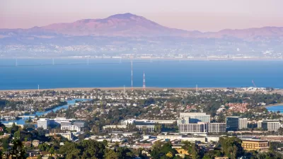
Maps included in the New York Times article feature the East San Francisco Bay Area as a clear example of the study's findings.
"The neighborhoods within Berkeley and Oakland that were redlined sit on lower-lying land, closer to industry and bisected by major highways. People in those areas experience levels of nitrogen dioxide that are twice as high as in the areas that federal surveyors in the 1930s designated as 'best,' or most favored for investment, according to the new pollution study," write Zhong and Popovich.
FULL STORY: Historical Redlining Is Associated with Present-Day Air Pollution Disparities in U.S. Cities

Pollution Does Discriminate in Orlando’s Parramore Neighborhood
Poor air quality has decimated the health of residents in this predominantly black community ringed by highways.
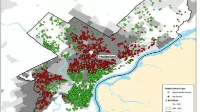
Court Complaint Accuses Redfin's 'Minimum Price Policy' of Redlining Minority Neighborhoods
A bombshell investigation accuses an online real estate company of a contemporary form of redlining.
Racial Disparity in Home Lending Is Today's Redlining
According to a new report detailing discriminatory lending in Chicago, people in majority-white neighborhoods continue to receive more loans, and in greater amounts, than people in majority-Black and majority-Latino areas.

Study: Maui’s Plan to Convert Vacation Rentals to Long-Term Housing Could Cause Nearly $1 Billion Economic Loss
The plan would reduce visitor accommodation by 25,% resulting in 1,900 jobs lost.

North Texas Transit Leaders Tout Benefits of TOD for Growing Region
At a summit focused on transit-oriented development, policymakers discussed how North Texas’ expanded light rail system can serve as a tool for economic growth.

Alabama: Trump Terminates Settlements for Black Communities Harmed By Raw Sewage
Trump deemed the landmark civil rights agreement “illegal DEI and environmental justice policy.”

How Community Science Connects People, Parks, and Biodiversity
Community science engages people of all backgrounds in documenting local biodiversity, strengthening connections to nature, and contributing to global efforts like the City Nature Challenge to build a more inclusive and resilient future.

Alabama: Trump Terminates Settlements for Black Communities Harmed By Raw Sewage
Trump deemed the landmark civil rights agreement “illegal DEI and environmental justice policy.”

Dear Tesla Driver: “It’s not You, It’s Him.”
Amidst a booming bumper sticker industry, one writer offers solace to those asking, “Does this car make me look fascist?”
Urban Design for Planners 1: Software Tools
This six-course series explores essential urban design concepts using open source software and equips planners with the tools they need to participate fully in the urban design process.
Planning for Universal Design
Learn the tools for implementing Universal Design in planning regulations.
City of Santa Clarita
Ascent Environmental
Institute for Housing and Urban Development Studies (IHS)
City of Grandview
Harvard GSD Executive Education
Toledo-Lucas County Plan Commissions
Salt Lake City
NYU Wagner Graduate School of Public Service