


Maryland approved ambitious plans for public transit expansion around Baltimore in 2002, but almost none of it became a reality. With a new plan in the works, transit boosters assess the loss of a generation's worth of progress.
Josh Kurtz performs a post-mortem on the recent history of transit planning in the state of Maryland—almost all of which never came to fruition.
In 2002, Maryland transportation planners put the finishing touches on a proposal to dramatically expand mass transit in the state. The plan envisioned six new or improved transit lines, with 122 new transit station stops built over 40 years.
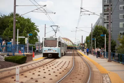
Today, only the Purple Line, a light rail project linking New Carrollton to Bethesda, survives. The Red Line, an east-west transit project in Baltimore, came close to final federal approval, but Gov. Lawrence J. Hogan Jr. (R) pulled the plug on the project in 2015.
The final nail in the coffin for those grand ambitions came in September when Maryland Governor Larry Hogan's administration announced that it would no longer prioritize the Corridor Cities Transitway, a bus rapid transit line in Montgomery County.
This post-mortem is set against the backdrop of a new transit planning study in the state, however: the Regional Transit Plan for Central Maryland. A draft plan is expected to be complete in a year, so the Greater Baltimore Committee and the Greater Washington Partnership recently held a public discussion on the future of transit in Maryland, but those in attendance couldn't avoid the past and the future.
As noted by Kurtz, several additional public forums on the Regional Transit Plan for Central Maryland are scheduled through the rest of the month.
FULL STORY: On Transit, Pondering What Might Be and Lamenting What Might Have Been


Central Maryland Regional Transit Plan: First Regional Transit Plan for Baltimore Since 2002
Transit planners in the Baltimore area are working on plans for a more reliable, useful regional transit system.
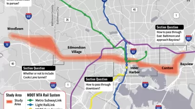
Maryland to Restart Planning for East-West Transit Line Through Baltimore
A plan for the Red Line, an east-west light rail line notoriously canceled by former-Governor Larry Hogan in 2015, is back on the table in Baltimore.

Monorail Study Moves Forward in Maryland
A plan to widen Interstate 270 in Maryland was approved earlier this year under the condition that the state also study a plan to build a monorail along the route.

Trump Administration Could Effectively End Housing Voucher Program
Federal officials are eyeing major cuts to the Section 8 program that helps millions of low-income households pay rent.

Planetizen Federal Action Tracker
A weekly monitor of how Trump’s orders and actions are impacting planners and planning in America.

Ken Jennings Launches Transit Web Series
The Jeopardy champ wants you to ride public transit.

California Invests Additional $5M in Electric School Buses
The state wants to electrify all of its school bus fleets by 2035.

Austin Launches $2M Homelessness Prevention Fund
A new grant program from the city’s Homeless Strategy Office will fund rental assistance and supportive services.

Alabama School Forestry Initiative Brings Trees to Schoolyards
Trees can improve physical and mental health for students and commnity members.
Urban Design for Planners 1: Software Tools
This six-course series explores essential urban design concepts using open source software and equips planners with the tools they need to participate fully in the urban design process.
Planning for Universal Design
Learn the tools for implementing Universal Design in planning regulations.
Ada County Highway District
Clanton & Associates, Inc.
Jessamine County Fiscal Court
Institute for Housing and Urban Development Studies (IHS)
City of Grandview
Harvard GSD Executive Education
Toledo-Lucas County Plan Commissions
Salt Lake City
NYU Wagner Graduate School of Public Service