


Communities need accurate maps and more access to data to increase flood resilience—but right now FEMA's not providing that.
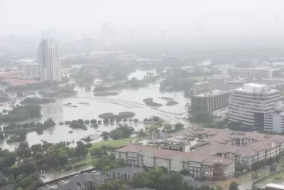
Across America, millions of families live in homes that are susceptible to flooding. And millions more could be at risk by the end of the century as the seas continue to rise and extreme weather events become more common. The National Flood Insurance Program (NFIP), for better or worse, plays a central role in the nation’s ability to address this growing threat.
Unfortunately, the federal flood insurance program has severe shortcomings—it has inaccurate and backward-looking flood maps, it’s not overly transparent about its flood risk and flood history data, and it doesn’t place enough emphasis on the importance of mitigation. These issues undermine everyone’s ability to accommodate and prepare for the damage wreaked to people’s homes by floods that are exacerbated by climate change. Homeowners and renters are left in the dark about their flood risk. This affects the community development field as well—affordable housing developers don’t have all the information they need to make siting and design decisions, and affordable housing lenders don’t have the information they need to appropriately underwrite flood-risk. This information gap distorts market signals, hinders fully informed decision making, and can lead to families being trapped in a nightmarish version of Groundhog Day: flooding, rebuilding, and repeating.
Congressional reform of the NFIP could help alleviate these problems, beginning with modernizing maps.
FULL STORY: The Uncertain Flood Zone


FEMA Resilience Program Cuts Grant Funding
The Building Resilient Infrastructure and Communities program funded projects from flood prevention to power station upgrades.

Rising Above: Innovative Solutions for Waikīkī’s Sea-Level Challenges
The University of Hawaiʻi at Mānoa’s award-winning Waikīkī sea-level rise adaptation project combines science, architecture, and community input to create scalable solutions for climate resilience and coastal flood mitigation.

America’s Housing Crisis: Lessons Ignored and Challenges Ahead
A recent study reveals how decades of policy missteps, demographic shifts, and economic forces fueled America’s housing crisis, leaving millions — especially millennials — struggling amid rising demand, racial disparities, and climate-driven emergencies.

Alabama: Trump Terminates Settlements for Black Communities Harmed By Raw Sewage
Trump deemed the landmark civil rights agreement “illegal DEI and environmental justice policy.”

Planetizen Federal Action Tracker
A weekly monitor of how Trump’s orders and actions are impacting planners and planning in America.

The 120 Year Old Tiny Home Villages That Sheltered San Francisco’s Earthquake Refugees
More than a century ago, San Francisco mobilized to house thousands of residents displaced by the 1906 earthquake. Could their strategy offer a model for the present?

Opinion: California’s SB 79 Would Improve Housing Affordability and Transit Access
A proposed bill would legalize transit-oriented development statewide.

Record Temperatures Prompt Push for Environmental Justice Bills
Nevada legislators are proposing laws that would mandate heat mitigation measures to protect residents from the impacts of extreme heat.

Downtown Pittsburgh Set to Gain 1,300 New Housing Units
Pittsburgh’s office buildings, many of which date back to the early 20th century, are prime candidates for conversion to housing.
Urban Design for Planners 1: Software Tools
This six-course series explores essential urban design concepts using open source software and equips planners with the tools they need to participate fully in the urban design process.
Planning for Universal Design
Learn the tools for implementing Universal Design in planning regulations.
Clanton & Associates, Inc.
Jessamine County Fiscal Court
Institute for Housing and Urban Development Studies (IHS)
City of Grandview
Harvard GSD Executive Education
Toledo-Lucas County Plan Commissions
Salt Lake City
NYU Wagner Graduate School of Public Service