


In the face of displacement and gentrification, residents of the Fruit Belt neighborhood of Buffalo, NY point to tech-giant Google's map service as one among many possible causes.
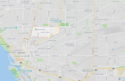
In the late 2000s, public outcry over the development of the Buffalo Niagara Medical Campus in the Fruit Belt neighborhood of Buffalo, NY brought shed light on a complex community identity conflict. Residents saw their drastically changing neighborhood undergo rapid transformation and gentrification. In addition to this displacement, they observed that the name of their neighborhood, the "Fruit Belt," was erased from Google Maps and replaced with the name "Medical Park."
In the historically Black and German immigrant neighborhood, "community members argued the designation was a calculated tweak in favor of gentrification, a digital rechristening," writes Caitlin Dewey. "The misnomer also revealed a great deal about the invisible process major tech firms use to put neighborhoods on their maps—and how decisions based off arcane data sets can affect communities thousands of miles away."
Digital erasure is not the only way the ownership of the Fruit Belt was forcibly removed from long-time residents, notes Dewey:
[D]evelopers tore down low-income townhouses and bought out a nearby African-American cultural center to make way for new apartments and medical offices. Worse, some residents reported rent hikes of as much as 50 percent, and one in three homes sat vacant and unused — a common sign that owners planned to resell them at a higher price.
As a result of Dewey's journalistic research, Good Maps corrected the name of the Fruit Belt. This acknowledgement of collective community autonomy is only a small step in the right direction.
FULL STORY: How Google's Bad Data Wiped a Neighborhood off the Map


10 U.S. Cities Launch Anti-Displacement Network
More than half of American tenants are rent-burdened, putting them at risk of displacement. A national collaboration with PolicyLink hopes to help.

A Bronx Community Fights to Have its Voice Heard
After organizing and giving input for decades, the community around the Kingsbridge Armory might actually see it redeveloped — and they want to continue to have a say in how it goes.

Placekeeping: Setting a New Precedent for City Planners
How a preservation-based approach to redevelopment and urban design can prevent displacement and honor legacy communities.

Trump Administration Could Effectively End Housing Voucher Program
Federal officials are eyeing major cuts to the Section 8 program that helps millions of low-income households pay rent.

Planetizen Federal Action Tracker
A weekly monitor of how Trump’s orders and actions are impacting planners and planning in America.

Ken Jennings Launches Transit Web Series
The Jeopardy champ wants you to ride public transit.

Rebuilding Smarter: How LA County Is Guiding Fire-Ravaged Communities Toward Resilience
Los Angeles County is leading a coordinated effort to help fire-impacted communities rebuild with resilience by providing recovery resources, promoting fire-wise design, and aligning reconstruction with broader sustainability and climate goals.

When Borders Blur: Regional Collaboration in Action
As regional challenges outgrow city boundaries, “When Borders Blur” explores how cross-jurisdictional collaboration can drive smarter, more resilient urban planning, sharing real-world lessons from thriving partnerships across North America.

Philadelphia Is Expanding its Network of Roundabouts
Roundabouts are widely shown to decrease traffic speed, reduce congestion, and improve efficiency.
Urban Design for Planners 1: Software Tools
This six-course series explores essential urban design concepts using open source software and equips planners with the tools they need to participate fully in the urban design process.
Planning for Universal Design
Learn the tools for implementing Universal Design in planning regulations.
Ada County Highway District
Clanton & Associates, Inc.
Jessamine County Fiscal Court
Institute for Housing and Urban Development Studies (IHS)
City of Grandview
Harvard GSD Executive Education
Toledo-Lucas County Plan Commissions
Salt Lake City
NYU Wagner Graduate School of Public Service