


The New York Department of City Planning is keeping itself on the cutting edge of internet technology.
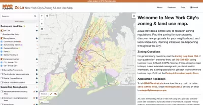
The New York Department of City Planning (DCP) recently announced updates to its Zoning and Land Use Application (ZoLa).
"ZoLa is a mapping tool that provides simple ways to research zoning regulations," according to a release announcing the upgrades.
Upgrades to the tool are intended to increase the tool's transparency, customization, and usefulness, with new functions like custom map creation, custom printing, street widths (previously available with the NYC Street Map), one-click access to the New York City Department of Housing Preservation and Development's Building, Registration, and Violation system, and easy access to special zoning district definitions.
The ZoLA upgrade is the latest in a string of web platform releases by DCP in recent years. Previous releases include ZAP Search, Zoning Resolution Online, Population Fact Finder, Community District Profiles, Metro Region Explorer, Waterfront Access Map, and NYC Street Map.
The in-house development team responsible for the ZoLa update, NYC Planning Labs, was recognized as a Planetizen Top Website in 2018.
FULL STORY: Increasing Transparency and Public Engagement: Department of City Planning Launches ZoLa 2.0


Opinion: Lower Rents Will Give Downtown Spaces Back to the ‘Weirdos’
Introducing the “CBGB theory of city planning.”

New York City Council Wants Community Engagement to Lead Affordable Housing Development
New York Mayor Eric Adams and City Council Speaker Adrienne Adams have proposed very different responses to the city’s lack of affordable housing.

A New Housing ‘Blueprint’ for New York City
With every new mayoral administration in New York City comes a new plan for addressing the city’s housing affordability crisis. Now it’s Mayor Adams’s turn.

Alabama: Trump Terminates Settlements for Black Communities Harmed By Raw Sewage
Trump deemed the landmark civil rights agreement “illegal DEI and environmental justice policy.”

Planetizen Federal Action Tracker
A weekly monitor of how Trump’s orders and actions are impacting planners and planning in America.

The 120 Year Old Tiny Home Villages That Sheltered San Francisco’s Earthquake Refugees
More than a century ago, San Francisco mobilized to house thousands of residents displaced by the 1906 earthquake. Could their strategy offer a model for the present?

Ken Jennings Launches Transit Web Series
The Jeopardy champ wants you to ride public transit.

BLM To Rescind Public Lands Rule
The change will downgrade conservation, once again putting federal land at risk for mining and other extractive uses.

Indy Neighborhood Group Builds Temporary Multi-Use Path
Community members, aided in part by funding from the city, repurposed a vehicle lane to create a protected bike and pedestrian path for the summer season.
Urban Design for Planners 1: Software Tools
This six-course series explores essential urban design concepts using open source software and equips planners with the tools they need to participate fully in the urban design process.
Planning for Universal Design
Learn the tools for implementing Universal Design in planning regulations.
Clanton & Associates, Inc.
Jessamine County Fiscal Court
Institute for Housing and Urban Development Studies (IHS)
City of Grandview
Harvard GSD Executive Education
Toledo-Lucas County Plan Commissions
Salt Lake City
NYU Wagner Graduate School of Public Service