


With a plan to build a Trinity Toll Road a thing of the past, there are now two plans for parks along the Trinity River. One would "rewild" the watershed.
Peter Simek provides in-depth coverage of the current state of park and open space planning along the Trinity River in Dallas.
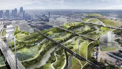
Plans first announced in 2016 for a new park designed by acclaimed landscape architect Michael van Valkenburgh lead to the "creation of a new quasi-governmental agency—a Local Governmental Corporation—to oversee the construction of the new park," explains Simek. As reported in 2017, river boosters lead by former councilmember Angela Hunt have also hatched plans for another park.
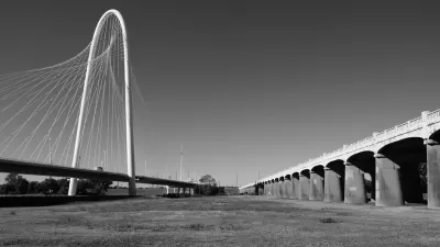
The planned Harold Simmons Park is only slated to be constructed between a 200-acre section of the floodway between the Ron Kirk Pedestrian Bridge and Interstate 30, a relatively small portion of the overall floodplain. What if there was a way to extend the restoration of the floodplain to a greater portion of the floodway?
Simek adds:
Since that time, Hunt and her collaborators have been kicking the tires and gathering supporters that include the National Audubon Society, which also helped coordinate last Saturday’s initial meeting. The group has identified a portion of the Trinity just north of the planned Simmons Park—between the Kirk Bridge and the Sylvan Avenue overpass (but excluding the existing Trammel Crow Park in the floodway). They believe this area can be restored into the kind of river-driven landscape that once characterized the Trinity floodplain before humans settled it.
Simek examines the politics of planning along the Trinity River, while also describing the planning and visioning exercises of the multiple groups working to implement a new vision for the Trinity River.
FULL STORY: Dallas May Now Get Two New Trinity River Parks

A Closer Look at the Big Park Plans Along Dallas' Trinity River
The Trinity River Project is coming into focus, after years of planning and decades of discussion. A $50 million donation in 2016 provided a big boost for Dallas' ambitious plans.
Is This the Trinity Park Plan of Dallas' Dreams?
Architecture critic Mark Lamster finally sees a proposal worth cheering for in Dallas' plans for a new park along the Trinity River.
Critic Sees 'Dallas Logic' in Latest Trinity River Plans
Mark Lamster has eviscerated the city of Dallas for its plans to build the Trinity Toll Road before—and he'll probably do it again.

Alabama: Trump Terminates Settlements for Black Communities Harmed By Raw Sewage
Trump deemed the landmark civil rights agreement “illegal DEI and environmental justice policy.”

Planetizen Federal Action Tracker
A weekly monitor of how Trump’s orders and actions are impacting planners and planning in America.

The 120 Year Old Tiny Home Villages That Sheltered San Francisco’s Earthquake Refugees
More than a century ago, San Francisco mobilized to house thousands of residents displaced by the 1906 earthquake. Could their strategy offer a model for the present?

In Both Crashes and Crime, Public Transportation is Far Safer than Driving
Contrary to popular assumptions, public transportation has far lower crash and crime rates than automobile travel. For safer communities, improve and encourage transit travel.

Report: Zoning Reforms Should Complement Nashville’s Ambitious Transit Plan
Without reform, restrictive zoning codes will limit the impact of the city’s planned transit expansion and could exclude some of the residents who depend on transit the most.

Judge Orders Release of Frozen IRA, IIJA Funding
The decision is a victory for environmental groups who charged that freezing funds for critical infrastructure and disaster response programs caused “real and irreparable harm” to communities.
Urban Design for Planners 1: Software Tools
This six-course series explores essential urban design concepts using open source software and equips planners with the tools they need to participate fully in the urban design process.
Planning for Universal Design
Learn the tools for implementing Universal Design in planning regulations.
Clanton & Associates, Inc.
Jessamine County Fiscal Court
Institute for Housing and Urban Development Studies (IHS)
City of Grandview
Harvard GSD Executive Education
Toledo-Lucas County Plan Commissions
Salt Lake City
NYU Wagner Graduate School of Public Service