


Washington Park is described as the jewel in the crown of Portland's park system. The city recently updated its master plan for the first time since 1981.
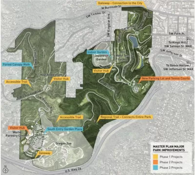
The city of Portland recently approved the Washington Park Master Plan, which addresses the long-term sustainability of the 481-acre park located just west of Downtown and the Pearl District in Portland's central city. According to the city website set up to detail the planning process, "the Washington Park Master Plan Update focuses on three major areas of improvement for the long-term sustainability of the 481-acre park: create identity, improve access, and enhance the visitor experience."
Jonathan Maus writes in support of the plan a few days after the Portland City Council adopted the master plan update, voicing support for the plan's transportation. Maus summarizes the transportation elements of the master plan as follows: "[to] keep cars on the periphery, reduce access for drivers, aggressively encourage transit use, create plaza and green spaces, and build protected paths for cycling and walking." The article includes more details about how the plan intends to attain that vision.
An article by Sam McCaffrey provides additional insight into the plan.
FULL STORY: Carfree Kingston, a rail-trail path and more: New plan puts Washington Park’s future in focus


All We Want for the Holidays is…
Here are a dozen timely gift ideas for creating better communities.
Draft West Portland Town Center Plan Seeks Public Comment
Always a closely watched planning jurisdiction, Portland, Oregon is proceeding with a new vision for the future of the western end of the city.

Rural Parks Planning Underway in Los Angeles County
The Los Angeles County Department of Parks and Recreation is conducting a survey to better understand the park and recreation needs of rural areas.

Trump Administration Could Effectively End Housing Voucher Program
Federal officials are eyeing major cuts to the Section 8 program that helps millions of low-income households pay rent.

Planetizen Federal Action Tracker
A weekly monitor of how Trump’s orders and actions are impacting planners and planning in America.

Ken Jennings Launches Transit Web Series
The Jeopardy champ wants you to ride public transit.

Rebuilding Smarter: How LA County Is Guiding Fire-Ravaged Communities Toward Resilience
Los Angeles County is leading a coordinated effort to help fire-impacted communities rebuild with resilience by providing recovery resources, promoting fire-wise design, and aligning reconstruction with broader sustainability and climate goals.

When Borders Blur: Regional Collaboration in Action
As regional challenges outgrow city boundaries, “When Borders Blur” explores how cross-jurisdictional collaboration can drive smarter, more resilient urban planning, sharing real-world lessons from thriving partnerships across North America.

Philadelphia Is Expanding its Network of Roundabouts
Roundabouts are widely shown to decrease traffic speed, reduce congestion, and improve efficiency.
Urban Design for Planners 1: Software Tools
This six-course series explores essential urban design concepts using open source software and equips planners with the tools they need to participate fully in the urban design process.
Planning for Universal Design
Learn the tools for implementing Universal Design in planning regulations.
Ada County Highway District
Clanton & Associates, Inc.
Jessamine County Fiscal Court
Institute for Housing and Urban Development Studies (IHS)
City of Grandview
Harvard GSD Executive Education
Toledo-Lucas County Plan Commissions
Salt Lake City
NYU Wagner Graduate School of Public Service