


A manifesto for street livability, health, and humanity in the era of driverless cars.
What is the best outcome for health and humanity in an autonomous vehicle future? How can we balance transportation efficiency with effective land use and a desire for livable cities? For planners, the best outcome is one that does not allow cars to dominate humans (pedestrians, bicyclists, and residents), likely achieved through a stronger, integrated, and balanced transportation-land use connection. At the very least, the future of transport should not degrade livability—leading to sprawl or lengthy trips, thereby paradoxically consuming any new capacity created by the technological advances of autonomous vehicles (AVs).
In simple terms, AVs offer three critical benefits with the potential to increase livability: 1) more street space for cyclists and pedestrians; 2) human scale vehicles and driving behavior (smaller vehicles, traveling at slower speeds, and enhanced ability to yield and stop); and 3) parking reductions and related changes for land use and development. But these benefits pivot on assumptions there will be little increase in vehicle capacity demands on our already burdened streets and communities. Unfortunately, this flies in the face of the growing number of studies showing we likely need to instead brace for significant capacity demand increases on our streets, driven in large part by the dramatic decrease in the personal cost of travel—when one can work, sleep, or socialize in a vehicle instead of having to drive it.
For example, according to UC Davis' 3 Revolutions report, without vehicle sharing we could see a 15% to 20% increase in overall vehicle capacity demand, assuming only a modest 50% reduction in the personal cost of travel. For more information on how lowering travel costs increases travel demand in a vicious cycle of sprawl and auto dependency, see this Wikipedia article on induced demand, or even better, this short cartoon from Nelson\Nygaard. In short, if we do not take deliberate action, we can expect dramatic increases in the number of vehicles traveling longer distances, demanding accommodation on already burdened streets and communities (as fictional robot overlords are known to do). All kidding aside, if unaddressed, these technological shifts could easily overwhelm the capacity to provide sustainable, livable, and equitable experiences for all in and around the most accessible public spaces—streets.
In response, a set of multi-disciplinary approaches are needed that embrace vehiclesharing, prioritize human travel and experiences, and proactivelycurbs sprawl to lower trip distances. For this, we offer the following manifesto that advances and goes beyond some of the broad policies proposed by others (3 Revolutions, Jeff Speck, Lisa Nisenson, and our own "Do the Right Things" article).
To increase vehicle sharing, future planning needs to emphasize the socialization and sharing of vehicles as we move into a brave new world of artificial intelligence and machine-learning driven lives. To curb sprawl and encourage urban reinvestment ("refilling") before the "spilling" forces of sprawl take hold, we need to employ strategies to achieve stronger, integrated, and balanced transportation-land use connections and transit corridor livability.
We can achieve this by planning and designing transportation and land use activities through a travel demand management (TDM) lens. A TDM-based approach would lower the amount of travel required, minimize the impact of that travel by lowering people's exposure to vehicle speeds and volumes, and ensure places and transport options are accessible without unduly harming vulnerable groups. Geared toward practitioners and their agencies, this manifesto outlines principles and practices organized under the following categories:The Vehicles, 2)Streets and Users, and 3)Land Use and Design ("refilling" urban cores before "spilling" sprawl). We hope you find this to be a useful guide for policy, planning, and management decisions going forward.
The Vehicles: Leverage for Sustainable Urbanism
1. Leverage new technology to determine pricing, use incentives, and utilize principles of behavioral economics, for both transportation and land use exchanges, and to facilitate a digital and just future mobility. In the emerging field of human dynamics, handheld computers (iPhones, Androids, etc.) can dramatically improve "urban access"—an individual's technology-enhanced capacity to discover, navigate, and participate in the exchange of opportunities, goods, and services that used to be somewhat hidden in urban environments—a phenomenon likely contributing to the success of the sharing economy in urban places--and likewise synergistically contributing to the success of urban places in general.
Therefore, civic leaders should leverage emerging technologies as much as possible to facilitate exchanges around transportation (e.g., Lyft, Uber, parking), and land use (e.g., housing) to help properly incentivize consumption and behavior, while also promoting social justice in transportation. For example, handhelds can now transmit what modes people are using, allowing regional transportation agencies to offer real-time transportation demand management programs that provide price and reward incentives for people willing to engage in sustainable or active travel (e.g., bicycling, walking, taking transit, and, of course, sharing vehicles). We also need to leverage new shared mobility options (e.g., bikeshare, Uber, Lyft, driverless shuttles), so people can cover the last mile to easily access transit and other local destinations. In doing so, cities might develop policies providing new levels of access to historically disadvantaged areas—whether they are in an urban core or an impoverished exurb. In sum, cities should embrace digital and equitable mobility as soon as possible to encourage and reinforce a future of vehicle sharing in urban environments.
2. Sustainable and human scale vehicle design. Policies, pricing, and incentives should encourage that AVs employ low emission technology—electric or, at the minimum, hybrid. Vehicles should be designed with pedestrians in mind—as "urban vehicles"—smaller to take up less space and with lower bumpers that work to lower injury severity. This coupled with humane aesthetic qualities can further enhance street livability comfort and enjoyment.
The Streets and Users: Design and Program for Livability and Humanity
3. Prioritize the needs of people, before vehicles. Prioritize the needs of pedestrians and bicyclists (especially children and the disabled) over autonomous vehicles, through infrastructure, street redesign, and how the vehicles are programmed to respond to pedestrians and bicyclists. For more information on programming AVs to recognize bicyclists, see the "Bicyclist's Manifesto for Autonomous Vehicle Future."
4. Proactively design and program streets and driving for livability, safety, and humanity. Areas of high vulnerable road user (VRU) activity should be protected by:
- Reducing the vehicle right-of-way
- The design of the streets, networks, and digital routing need to respect the context for travelers and residents alike. Traffic should be routed onto appropriate streets, recognizing road hierarchies. Cutting traffic through residential neighborhoods, or staging unparked, cruising cars within them, should be avoided at all costs.
- Limiting the speed of autonomous vehicles in urban areas wherever pedestrians are present to 12 MPH, and corridors accessing them to 20 MPH (max!), optimizing street comfort and livability for all. Studies, show how fatalities dramatically increase when collision speeds goes above 20 mph—a possible explanation for this is that we, as humans, have evolved to withstand head trauma at the highest speeds we can run—therefore let’s let the physio-biologic aspects of our humanity dictate our travel speeds, not the inhuman design of vehicles and roads, as dictated by the antiquated 85th percentile rule.
As a priority, vehicle standards should protect and promote active travel behavior. While in the past cities have relied primarily on street redesign to passively control the speed and domain of vehicles, with autonomous vehicles cities and regions now need the authority to program vehicle behaviors directly—deliberately prioritizing people and human transport in the modal hierarchy. All these factors emphasize the need for city planners and policy makers to dialogue with the tech community.
Land Use Planning and Design: "Refilling" (With Urban Reinvestment) Before "Spilling" (Sprawl)
5. Encourage urban reinvestment to "refill" urban core areas before "spilling" onto sprawl. As soon as possible, urban core areas, centers, and transit oriented developments should seek to leverage infill opportunities ("refilling"), encouraged largely by reductions in parking demand and, by extension, related construction costs, before the "spilling" forces of autonomous vehicle driven sprawl get underway.
How this "refilling" dynamic will catalyze around reductions in parking demand to lower construction costs is illustrated through a study by Audi, which finds that self-parking cars could potentially lower space requirements by as much as 60%. (We believe further reductions could be realized with greater levels of sharing.) According to Gary London, of San Diego's London Moeder advisors, these reductions will likely reduce the costs of construction, change land valuations, and facilitate infill development, which, could be reduced 20-25% if structured parking is eliminated. Therefore, to offset the "spilling" effects of AV induced sprawl, cities should leverage these "refilling" opportunities as much as possible.
6. A good regional land use plan is a good regional transportation plan. Manage land use patterns to lower trip distance and get ahead of the AV-driven "spilling" forces of sprawl. Urban growth boundaries (UGBs) like those in Portland and Oregon, and "pricing open space and incentivizing infill" as suggested by UC Davis' 3 Revolutions, are all sound policies, but they will likely face political uphill battles in most places. Rather than count on any one politically challenging proposition, planning agencies in urban, transit-rich areas should move forward as soon as possible with strategies and incentives (“carrots) to accommodate infill ("refill”) that will achieve lower travel demand through better jobs-housing balances and easy access to other important destinations.
Nevertheless, regional and local agencies should still institute meaningful comprehensive regional land use and growth management planning seeking mostly to provide incentives for infill development and reduces the potential for urban sprawl with the objective of lowering overall trip distances. For example, land use planning should seek to achieve better jobs-housing balances to lower the amount of vehicle travel. A vehicle-miles traveled (VMT) policy should be supported and related pricing mechanisms should be supported at a federal policy level.
7. Available parking spaces coming soon: strategically leverage newly available space to further offset the forces of sprawl. Because parking lots are fairly controlled environments, AV technology could be quickly deployed there, thereby rapidly freeing up valuable, former parking land on and off the streets. Adaptive reuse of parking spaces could facilitate redevelopment of much needed affordable housing in the most expensive areas. It could also lead to the conversion of parking lots to other important uses. For example, a new parking structure designed by Safdie Rabines Architects for UC San Diego will be constructed so it can eventually be converted to classrooms. Finally, planners should seek to convert on street parking spaces to places for people and place-making, such as bike lanes, parklets, or simply wider sidewalks. Planners should begin to accommodate this shift now by proactively changing the zoning and parking requirements to take advantage of these shifts, with the following next step.
8. "Refill" and prioritize the vitality of urban transit corridors and TODs through land use planning and urban design (place-making). A study by Clewlow and Shankar Mishra has shown that ride-hailing cannibalizes transit ridership, suggesting how AVs might threaten and undercut the primacy of urban transit corridors. Therefore, deliberate actions should be taken to focus and maintain the vitality of transit corridors and urban places by concentrating activities in walkable distances to priority transit lines. When applying this principle, be focused, intentional, and deliberate to make sure priority areas receive the benefits and attract the "refilling" opportunities first. Good policy models can be found in California’s recently passed pro-housing legislation, specifically California State Senator Scott Wiener’s SB 827, which allows increased housing density around public transit.
As mentioned above, seek also to leverage shared mobility options (e.g., bikeshare, uber, lyft, driverless shuttles) to cover the last-mile and feed people to transit and other local destinations. For assistance with identifying "refilling" versus "spilling" areas, and then developing policy strategies, see the Transportation Research Board's Livability Calculator and Handbook for Building Livable Transit Corridors.
9. Proactively change zoning and parking requirements in order to prioritize the "refilling" of urban areas before "spilling" onto sprawl. At the recent ACSP roundtable, Jonathan Levine, author of Zoning Out, said "technology does not change policies, people do!" Along these lines, planners should proactively make changes to parking requirements and zoning—these actions are already taking place in some communities. To get in front of the sprawling effects of AVs, we recommend proactively changing zoning ordinances and parking requirements to be more flexible and inclusive—with maximum-to-no parking, minimum density, and height requirements—we recommend being focused, intentional, and deliberate in applying changes to priority "refilling" areas, before "spilling" areas, so they receive the benefits first. Again, California State Senator Scott Wiener's SB 827, which allows increased housing density around public transit, is a good model to consider enacting.
10. Value planning: create a vision, a performance measurement framework, and scenario testing process that can serve to guide subsequent planning decisions. Good planning is one of the most effective ways to add value at low cost to any community, region, or situation—simply put, it is a matter of informed, multi-disciplinary conversations to fully understand the problems, and then craft agreeable and actionable solutions to move use forward. Lisa Nisenson, in her "Autonomous Urbanism" article, suggests that the first step is to define success. For this, we can build on the "Doing the Right Things" article for a transportation-land use integration (TLI) performance measurement framework to be used in scenario testing and back-casting. For scenario testing, as well identification and assessment of "refilling" versus "spilling" areas, we can again use the Transportation Research Board's Livability Calculator and Handbook for Building Livable Transit Corridors.
If these steps can be followed to achieve greater vehicle sharing and less sprawl—thus minimizing overall growth in vehicle capacity demands on our systems—we stand a better chance to both lower speeds and optimize the amount of street space we can recapture for street-life and livability, and thereby advancing a more sustainable, livable, and equitable future with autonomous vehicles.
Let's get together with all key stakeholders to shape an inclusive vision for a sustainable, livable, and equitable future with driverless cars. To achieve these objectives, we need a seat at the table to properly understand the issues and help design the solutions. To address these concerns, we propose creating something like a "Union of Concerned Planners, Engineers, & Designers" that might be modeled after the Union of Concerned Scientists, but for the applied professions. Conversely something akin to a reconvening of the Telesis group might spur a new urban conversation that is both thoughtful and directive about how we can plan cities that are both sustainable and just in the face of emerging technology. Irrespective of the name of nomenclature, the time is now for us to do the right thing and take action. Let's make our streets and communities livable, healthy, and humane for our children and our children's children.
This manifesto is based on findings from the paper "Do the Right Things" by Appleyard and Riggs, the results of a Roundtable Session at the ACSP Conference: Street Livability, Health and Humanity in the Era of Driverless Cars on 10/14/17, a land use session at the Autonomous Vehicle Forum hosted by Circulate San Diego on 9/28/17, and a presentation at UCSD's Contextual Robotics Forum on 10/28/17.
The authors wish to thank: Gary London, Jonathan Levine, Robert Schneider, Henrik Christensen, Todd Hylton, Colin Parent, Lisa Nisenson, Adam Millard-Ball, Marc Schlossberg, Michael Boswell, Kelcie Ralph, Nico Larco, Ralph Buehler.
Dr. Bruce Appleyard is an associate professor of City Planning/Urban Design at San Diego State University, where he helps people and agencies make more informed decisions about how we live, work and thrive. He is humanist/futurist at the intersection of transportation, urban design, and behavioral economics, crafting articles, workshops, and lectures designed to help people reach their sustainability, livability, and equity objectives by helping them measure and understand the key underlying issues, and then enact solutions to effectively address them.
William (Billy) Riggs Ph.D., AICP, LEED AP, is an assistant professor at University of San Francisco and researcher, strategist and thought leader in the areas of transportation, housing, economics, and emerging technology. He has over 50 publications in these areas, and has had his work featured in multiple national media outlets—including the Wall Street Journal, Washington Post, and the Atlantic. He is the co-creator of ReStreet.com, a tool for democratizing street design policy and process.

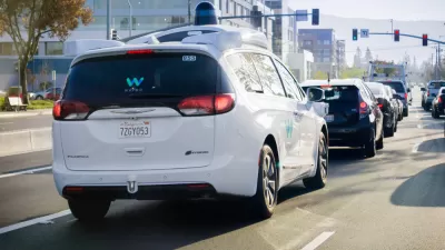
How Autonomous Cars Can Induce Sprawl and Sabotage Climate Goals
Robotaxis can lead to longer, more frequent trips and are projected to increase VMT by as much as 83 percent.
Still No Flying Cars: The Underwhelming Progress of Autonomous Vehicles
While we're still far from a Jetsons-style reality, understated autonomous features could be the key to safer transportation.
Waymo One Now Offering Fully Autonomous Rides to the General Public
Is this the "Kitty Hawk moment" driverless car companies have been seeking?

Trump Administration Could Effectively End Housing Voucher Program
Federal officials are eyeing major cuts to the Section 8 program that helps millions of low-income households pay rent.

Planetizen Federal Action Tracker
A weekly monitor of how Trump’s orders and actions are impacting planners and planning in America.

Ken Jennings Launches Transit Web Series
The Jeopardy champ wants you to ride public transit.

California Invests Additional $5M in Electric School Buses
The state wants to electrify all of its school bus fleets by 2035.

Austin Launches $2M Homelessness Prevention Fund
A new grant program from the city’s Homeless Strategy Office will fund rental assistance and supportive services.

Alabama School Forestry Initiative Brings Trees to Schoolyards
Trees can improve physical and mental health for students and commnity members.
Urban Design for Planners 1: Software Tools
This six-course series explores essential urban design concepts using open source software and equips planners with the tools they need to participate fully in the urban design process.
Planning for Universal Design
Learn the tools for implementing Universal Design in planning regulations.
Ada County Highway District
Clanton & Associates, Inc.
Jessamine County Fiscal Court
Institute for Housing and Urban Development Studies (IHS)
City of Grandview
Harvard GSD Executive Education
Toledo-Lucas County Plan Commissions
Salt Lake City
NYU Wagner Graduate School of Public Service