


Many rational, open grids can seem like a labyrinth to users. The labyrinth has emerged as an unplanned consequence of the evolution of cities, but solutions like GPS navigation and autonomous vehicles could mean relief.
Two friends, long-time residents of the same city, could not make it unaided to my house in the central district, which is laid out on a typical, orthogonal grid. I succeed in navigating this district unaided daily.
Such an event is surprising when knowing that for most of history, city streets had no names and buildings no numbers, including those of great cities such as Rome, Athens, London, Paris, Tokyo, and more. Add to this absence of pointers the irregular, confusing configurations of their networks, and an image of people lost and scared in a labyrinth springs to mind. Nothing of the sort happened. Residents of such places carried on their daily lives entirely unperturbed by the networks' labyrinthine configuration or by the absence of names and numbers. My friends failed even with these pointers—in a grid.
Here we explore the inconceivable, yet real, possibility that a rational, open grid can morph into a virtual labyrinth. We find that assertions to the contrary are based on abstractions—not contemporary, on-the-ground experience.
Driving matters
Since both our collective ancestors and my visitors used the same rational network, the only probable cause for my visitors being lost is that they drove. Nothing else separates the two. How is it that driving in this network gets a driver lost but walking leaves a walker immune?
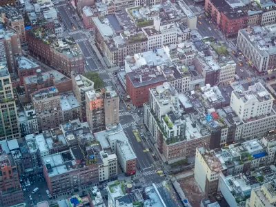
In the 100-plus years since its introduction, cities had to adapt to the car's omnipresence. And since the street infrastructure remained fixed, adaptations could only be operational. Figure 1. shows the inherited, century-old, central-district ground plan. Its current operational code, which is aimed at drivers, cannot be reflected in the plan; it is encoded in a 100-plus sign-and-signal language, not geometry. No such language existed before, and none was needed. Now it is imperative. Drivers would ignore it at their own peril. For visitor-drivers, not concentrating and obeying it fully could mean getting hopelessly lost. Even when they do, it proves frequently insufficient.

How people get lost
Constructed hedge mazes in royal gardens or amusement parks give us clues about how to confuse visitors: First, an undifferentiated visual field and second, bifurcations with dead ends. The first trick continually raises the "where am I?" question while the second—"no way through, again!"—quashes confidence in finding a way out. Lack of recognition and lack of success induce anxiety, even panic.
In principle, urban settings should be exactly the environment where such sensations do not arise; they are rich in all manner of sensory inputs. But a replete sensory field is practically useless for navigation to a newcomer because there can be norecognition of place, just as in a homogenous maze field. Paradoxically, "newness" has the identical effect as "sameness." Directions notwithstanding, the search for an address can feel excessively long and anxiety-ridden, because all surroundings are new and none recognizable. For residents, on the other hand, every step provides a sense of "arrival," an instant recognition of place.
Recognition is unavailable to visitors, particularly drivers: recording images and recollecting them is severely hampered by driving: The confined windshield vision cone, heightened attention on traffic and signs, and compelled motion limit the extent of images recorded or recognized. In addition, the driver sign-and-signal code compound these limitations by arbitrarily restricting movement options. The combined effect of newness, driver limitations, and the driving code result in people getting lost.
The driver code and its effect
When deciphered, the code reveals a most dramatic change: the choices of direction at intersections are starkly different for drivers from the choices of direction for pedestrians. Figure 2 shows the relative degree of freedom for the two with the operational rules in force.

Only five (4%) out of the 129 intersections in this district offer three choices to drivers, while 126 (93%) do so for pedestrians. In other words, the essential characteristic of the grid—three route choices at intersections—has all but been obliterated for the driver: identical physical infrastructure, startlingly unequal freedom of movement. And since choice is critical in charting a path toward a destination, limiting choice sets a navigation trap—the first step toward a maze. Limiting direction choices, results in halving access points to places inside the driver grid blocks (fig.3). From a visitor's perspective, there is only a 50% chance of turning to a street with a good arrival prospect, exactly the chances at a bifurcation in a maze. One of two paths is hopeless.

The second step in trapping the visiting driver is even more treacherous. The one-way street compels a forward motion. There is no option to turn around as a two-way street might afford a driver (turning around, however, is something a pedestrian can do on any street).
If a driver makes an error, moving forward without a corrective plan adds to confusion and anxiety.

There are altogether eight streets inside the block, four in each cardinal direction, but only four driving entry points—two from each of two nearest sides from the north intersection. There are 20 typical destination points for each set of streets, and 40 altogether. The turns required to reach each of these points are shown in Fig. 5. Selecting an entrance point is critical but also perplexing. The "right" entrance for drivers cannot be deciphered while driving; it could be the right street but wrong direction, or right direction and wrong number sequence; none of this information is available in advance of turning. Figure 4 shows clearly the driver's relative disadvantage compared to a walker in reaching the same destination: 3 turns vs one.

The percentages in figure 5 make the driver's predicament clear. Only one quarter of all destinations can be reached with just one turn. The rest require two, three, or more turns. Moreover, 15% cannot be reached at all from within the driver block.

Compounding these complications, the district's 129 intersections include a few that are entirely blocked with bollards and others that force a driver to turn even though the street itself continues through (see fig 6). For a driving visitor, encountering these cases could be a panic shock: unable to plan the next move, having anticipated an uninterrupted path—the pure experience of a labyrinth.

A graphic interpretation of a driver's experience (fig.7), shows that if the chosen entry is the destination street and its number sequence correct, arrival is certain. If not, and the destination is elsewhere in the block, the driver will face bifurcations, just as in a maze, of which only one path is worthwhile. Under pressure to move and lacking time to decipher numerous signs, names and numbers, an error is often unavoidable. Realizing it, triggers the sensation of being lost and panic follows. As in a maze, so in a code-managed grid: one mistake can precipitate a collapse of confidence in finding a destination. Whatever the layout, the superstructure of a language on the physical structure has created a virtual labyrinth. Guidance such as "…Turn left at the second set of lights and then right at the first stop sign…" exemplifies this language, which renders physical objects, distances and layouts irrelevant.
Conclusion
It comes as no surprise that the physical structure of the city has been rendered inconsequential by the superstructure of a driving language. Driving is new in the 6,000-year history of cities, and it generated a sudden disruption and elevated risks. It required urgent assimilation. Rushed, reactive solutions, rather than longer-term adaptations, were inevitably prone to lack a comprehensive and error-free functionality. This is the ironic case of the orthogonal labyrinth; with a driving code superposition as a necessary complement, its simple, repetitive geometry proves unhelpful, if not problematic.
But help is now available and more pending: For residents, habituation is the natural solution. Fortuitously, a solution for visitors has also emerged: a new invisible physical infrastructure (transmission-towers) and a language superstructure with embedded intelligence: the GPS guided driving. An additional solution would soon be available to all residents and visitors: autonomous vehicles. Taken together, these adaptations will finally relieve the driver of all anxiety. They will also free the planner's hand in laying out new district networks with walkability as a high priority, unconstrained by the esoteric, non-quantifiable, concept of legibility.
Fanis Grammenos is the director Urban Pattern Associates in Ottawa, Ontario and the author of Remaking the City Grid: A Model for Urban and Suburban Development. Reach him by email with questions or comments.

Study: Automobile Dependency Reduces Life Satisfaction
Automobile dependency has negative implications for wellbeing. This academic study finds that relying on a car for more than 50 percent of out-of-home travel is associated with significant reductions in life satisfaction.
The Man Who Made Chicago Easy to Navigate
Edward Brennan waged an extended turn-of-the-century campaign to clean up Chicago's then-confusing address numbering system. Though few recognize his name, Brennan's legacy lives on in modern Chicago.

Blinded by the Light: When Brighter Headlights Decrease Safety
Bright LED headlights can create glare and reduce visibility for other drivers and pedestrians.

Alabama: Trump Terminates Settlements for Black Communities Harmed By Raw Sewage
Trump deemed the landmark civil rights agreement “illegal DEI and environmental justice policy.”

Planetizen Federal Action Tracker
A weekly monitor of how Trump’s orders and actions are impacting planners and planning in America.

How Atlanta Built 7,000 Housing Units in 3 Years
The city’s comprehensive, neighborhood-focused housing strategy focuses on identifying properties and land that can be repurposed for housing and encouraging development in underserved neighborhoods.

In Both Crashes and Crime, Public Transportation is Far Safer than Driving
Contrary to popular assumptions, public transportation has far lower crash and crime rates than automobile travel. For safer communities, improve and encourage transit travel.

Report: Zoning Reforms Should Complement Nashville’s Ambitious Transit Plan
Without reform, restrictive zoning codes will limit the impact of the city’s planned transit expansion and could exclude some of the residents who depend on transit the most.

Judge Orders Release of Frozen IRA, IIJA Funding
The decision is a victory for environmental groups who charged that freezing funds for critical infrastructure and disaster response programs caused “real and irreparable harm” to communities.
Urban Design for Planners 1: Software Tools
This six-course series explores essential urban design concepts using open source software and equips planners with the tools they need to participate fully in the urban design process.
Planning for Universal Design
Learn the tools for implementing Universal Design in planning regulations.
Jessamine County Fiscal Court
Caltrans
Institute for Housing and Urban Development Studies (IHS)
City of Grandview
Harvard GSD Executive Education
Toledo-Lucas County Plan Commissions
Salt Lake City
NYU Wagner Graduate School of Public Service