


A list of mobile apps that support planning, as part of an annual update. Learn about exciting new ways to explore cities and enhance planning via mobile apps. Please feel free to add your own favorites.


Mobile apps can enhance civic engagement and advocacy in local governance and planning, make more efficient use of time in data collection and analysis for planners, and a slew of other functions. Edgar Ables, a Master’s of City and Regional Planning Student at Ohio State University, and myself have been collecting and evaluating mobile apps looking to share what we see as most useful.
Every year, I survey a cross-section of planners to develop a comprehensive list of some of the most unique, useful, and the most ubiquitous mobile apps for planners. Over the course of this year we have surveyed planners about their professional use of mobile apps, what would they like to see in the future, and what apps either they themselves or their office is developing. I invite you to participate.
We heard from many planners from across the United States and a few abroad as well. Of the respondents 100% own either a smartphone or a tablet, up from 96% last year. Planners who responded were asked about various types of apps that they use and the frequency of their use. Around ninety percent of all planners surveyed stated that they active utilize their mobile device for work purposes.
Planners this year reported they are using Google Slides to allow multiple users to work simultaneously on the same presentation from anywhere. As with last year, the most commonly used apps by planners in their daily lives are social media apps, such as Twitter and Facebook. Note taking apps are also popular for daily use; and apps like Photoshop, PowerPoint, and Prezi are more frequently used on a monthly basis.
Popular this year are Uber, Google Plus, Google Drive, Skype, Weather Channel, One Note, and Evernote. Mentioned in this year as well as in previous years planners are using apps such as Todoist, Constant Contact, Dropbox, Mediafire, GoogleMaps, ArcGIS, Trulia, Zillow, GoToMeeting, and SlideShark. Here are a few apps that planners told us about that I found to be particularly interesting.
- Boardvantage: Streamlines meetings by securely disseminating board meeting materials and allows for reviewing and approving of documents (Android, iOS, WindowsPhone).
- CabSense NYC: Gives real-time data on Yellow Cabs in NYC (iOS & Applewatch, Android).
- Poll Everywhere: Users create a poll that can be answered in real time using mobile phones, web browsers, and via Twitter. The results are viewable in real-time online, in Keynote, Google Slides, or PowerPoint (Android, iOS and Windows Phone).
- Redbooth: Teams can collaborate on projects, share files, and communicate with each other, all from one central, searchable workspace that’s available anytime (Android, iOS & Applewatch).
- TowIt: TowIt works with municipal governments, local law enforcement, and towing companies to remove the barriers required for cities to effectively deter bad parking and dangerous driving habits (Android and iOS).
- HERE Maps: A unique feature of HERE Maps provides off-line turn-by-turn navigation. The app also includes indoor venue maps for many locations, such as airports and shopping malls (Android, iOS and WindowsPhone).
- Trello: This project management software allows many people to collaborate in real-time (Android and iOS).
- TripIt: This travel tool allows forwarding of travel details to one, accessible location (Android, Blackberry, iOS, and Windows Phone).
In the survey, planners were asked whether or not their organization has created an app or discussed creating an app. Twenty-three percent responded that their organization has created an app or is in the process of creating an app, which is a 6% increase from last year. And 29 percent responded that their organization is discussing creating an app in the future, the same as last year. Below are a number of the apps created by agencies employing planners. My favorite is MySurrey which allows citizens to ask questions much like you would with Siri.
- ArlingtonVA: With the ArlingtonVA app, users can report service requests or problems directly to Arlington County government, along with a photo of the issue (pothole, broken streetlight, fallen tree, damaged playground, missing sign, etc.). The service requests are instantly routed to the right county division. Users also receive a tracking ID for the submitted item, and notifications follows update or resolution of the issue (Android and iOS).
- Arlington Prepares: This app informs individuals of what to do in case of an emergency, with up-to-the-minute alerts and sources for local emergency news. It also teaches how to create disaster kits; choose emergency meeting places; and quickly access personal and medical information as well as public and personal emergency contact phone numbers (Android and iOS).
- AccessABLE: This app provides detailed information about directions, ramps, lifts, and accessible toilets. There are various versions of this app for different specific locations in Leicester, England
(iOS).
- Coral Gables: Allows users to make a service request, learn about city services, and find parking (Android and iOS).
- MySurrey: Think "Siri for Cities." The app answers questions such as "why wasn’t my trash picked up today?" and "How many chickens can I keep on my property?" (Android, iOS and AppleWatch).
- NCCCSport: Nottingham, England allows users to sign up for fitness classes, book a gym session, reserve a court, and more via mobile device (Android and iOS).
- ParkDetroit: Allows users to park at public meters via their mobile phone (Android and iOS).
- Walking Glasgow: Provides suggested walking paths, photos of points of interest and allows users to share their walking paths in Glasgow, Scotland (Android and iOS). The city also offers Cycling Glasgow allowing users to share their cycling routes (Android and iOS).
- Dundee Waterfront 2018: Allows users to tour the future of the Dundee, Scotland waterfront, showing key development sites (Android and iOS).
Beyond those being used by survey respondents here are some recent apps that I found particularly useful.
- Alternative Fueling Station Locator: This app provides locations for alternative fueling stations (iOS).
- Bike Citizens: This app focuses on routes best for cyclists, avoiding busy main streets. The app operates in many cities in Europe (Android and iOS).
- Carrot Rewards: The Canadian government has released an app that encourages Canadians to lead healthier lives by offering rewards (iOS).
- CityAirApp: In London this app provides the best routes to take to avoid air pollution. The app allows users to map walking, cycling, or transit routes to minimize air pollution impacts (web only).
- CityMaps2Go: This travel app provides offline maps and curated travel information (Android and iOS).
- Roger: This is a walkie-talkie app. You hold down a button, record a message, and send it to a contact. (iOS)
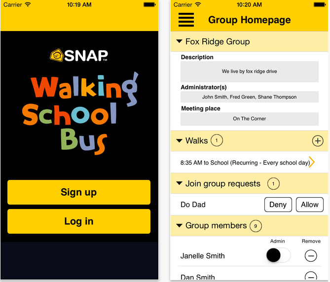
- Walking School Bus: The Utah Department of Transportation created a walking school bus app that allows parents to create or join a walking school bus (iOS).
And because city planners like to have fun too, here is a game that planners may find amusing. TocaLifeCity is a storytelling app allows kids and adults to decide what happens next in their city. (Android, Kindle, iOS and Windows Phone)
All in all it has been a great year for planning and apps that support our communities. May the new year bring even more wonderful advancements in mobile technology to support our cities. I encourage you to share your favorite apps in the comments below and to complete the survey on your use of mobile apps. You can also see the previous years best apps, 2015, 2014, and 2013.


The Best Planning Apps for 2015
A list of mobile apps that support planning, as part of an annual update. Learn about exciting new ways to explore cities and enhance planning via mobile apps. Please feel free to add your own favorites.
The Best Planning Apps for 2017
A list of mobile apps that support planning, as part of an annual update. Learn about exciting new ways to explore cities and enhance planning via mobile apps. Please feel free to add your own favorites.
Best Apps for Urban Planning in 2022
Mobile apps continue to redefine the practices of planning—urban planning, regional planning, transportation planning, community planning, and rural planning included.

Study: Maui’s Plan to Convert Vacation Rentals to Long-Term Housing Could Cause Nearly $1 Billion Economic Loss
The plan would reduce visitor accommodation by 25,% resulting in 1,900 jobs lost.

North Texas Transit Leaders Tout Benefits of TOD for Growing Region
At a summit focused on transit-oriented development, policymakers discussed how North Texas’ expanded light rail system can serve as a tool for economic growth.

Using Old Oil and Gas Wells for Green Energy Storage
Penn State researchers have found that repurposing abandoned oil and gas wells for geothermal-assisted compressed-air energy storage can boost efficiency, reduce environmental risks, and support clean energy and job transitions.

Private Donations Propel Early Restoration of Palisades Playground
Los Angeles has secured over $1.3 million in private funding to restore the Pacific Palisades playground months ahead of schedule, creating a modern, accessible space that supports community healing after recent wildfires.

From Blight to Benefit: Early Results From California’s Equitable Cleanup Program
The Equitable Community Revitalization Grant (ECRG) program is reshaping brownfield redevelopment by prioritizing projects in low-income and environmental justice communities, emphasizing equity, transparency, and community benefits.

Planting Relief: Tackling Las Vegas Heat One Tree at a Time
Nevada Plants, a Las Vegas-based nonprofit, is combating the city’s extreme urban heat by giving away trees to residents in underserved neighborhoods, promoting shade, sustainability, and community health.
Urban Design for Planners 1: Software Tools
This six-course series explores essential urban design concepts using open source software and equips planners with the tools they need to participate fully in the urban design process.
Planning for Universal Design
Learn the tools for implementing Universal Design in planning regulations.
Ascent Environmental
Borough of Carlisle
Institute for Housing and Urban Development Studies (IHS)
City of Grandview
Harvard GSD Executive Education
Toledo-Lucas County Plan Commissions
Salt Lake City
NYU Wagner Graduate School of Public Service