


Revisiting one day in 2012, a reporter finds that many of the Dallas-Fort Worth areas affected by the storms were barely inhabited 20 years ago.
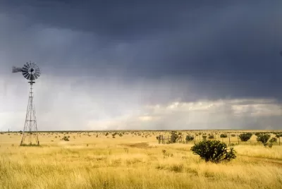
At the Texas Tribune, Daniel Levy recounts one day in 2012 during which 17 tornadoes caused $700 million in damages across the Dallas-Fort Worth area. It’s partly memorable for the 110 airplanes taken out, but it’s also memorable because it demonstrates how sprawl makes people and places more vulnerable to natural disasters.
The strongest tornado of the day struck Forney, a suburb 20 miles east of downtown Dallas. Forney has grown by more than 230 percent since 2000, adding 13,000 residents. At 2:33 p.m., an EF-3 tornado with peak winds of 170 mph tore through more neighborhoods, including the Diamond Creek subdivision, that didn’t exist a decade before.
The article includes a map showing the various paths of the various tornadoes; it demonstrates that many of them of them started, ended or passed through areas that have only been developed in the last 20 years, and others passed through areas that will likely be developed in the next 20.
FULL STORY: As cities sprawl, more Texans are exposed to tornadoes

Zoning for Good
A new book highlights the power of zoning to change communities for the better.
Is Sprawl the Only Answer to High Housing Costs?
A recent article argues that sprawl is the solution to high housing costs, pointing out that low-density Sunbelt cities are more affordable than some more compact metro areas. What's wrong with this argument?
Report: Sprawl Affecting Farmers in Greater Washington Region
According to a recent report, the self-sufficiency of agriculture in the Washington, D.C. region is declining. Encroachment from suburban sprawl, driven by a region-wide housing crunch, is one causal factor.

Alabama: Trump Terminates Settlements for Black Communities Harmed By Raw Sewage
Trump deemed the landmark civil rights agreement “illegal DEI and environmental justice policy.”

Planetizen Federal Action Tracker
A weekly monitor of how Trump’s orders and actions are impacting planners and planning in America.

Why Should We Subsidize Public Transportation?
Many public transit agencies face financial stress due to rising costs, declining fare revenue, and declining subsidies. Transit advocates must provide a strong business case for increasing public transit funding.

Understanding Road Diets
An explainer from Momentum highlights the advantages of reducing vehicle lanes in favor of more bike, transit, and pedestrian infrastructure.

New California Law Regulates Warehouse Pollution
A new law tightens building and emissions regulations for large distribution warehouses to mitigate air pollution and traffic in surrounding communities.

Phoenix Announces Opening Date for Light Rail Extension
The South Central extension will connect South Phoenix to downtown and other major hubs starting on June 7.
Urban Design for Planners 1: Software Tools
This six-course series explores essential urban design concepts using open source software and equips planners with the tools they need to participate fully in the urban design process.
Planning for Universal Design
Learn the tools for implementing Universal Design in planning regulations.
Caltrans
Smith Gee Studio
Institute for Housing and Urban Development Studies (IHS)
City of Grandview
Harvard GSD Executive Education
Toledo-Lucas County Plan Commissions
Salt Lake City
NYU Wagner Graduate School of Public Service